Lima Metropolitan Area
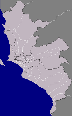
The Lima Metropolitan Area (Spanish: Área Metropolitana de Lima) is a massive urban conurbation—a region where multiple cities merge into one continuous built-up area—formed by the Peruvian provinces of Lima and Callao. As the largest metropolitan area in Peru, it stands as the fourth largest in Latin America and the seventh largest in the Americas, ranking among the thirty largest urban centers globally.
The process of conurbation became particularly evident in the 1980s, transforming the capital and its neighboring port into a singular, sprawling megacity. Today, it serves as the primary economic and political hub of the Andean region.
Key Facts
- Total Population: Estimated 11,804,609 (2022).
- Economic Power: Nominal Metro GDP of US$ 114 billion (2023), with a per capita GDP of US$ 10,200.
- Global Status: Classified as a Beta + city by the Globalization and World Cities Research Network.
- Geography: The world's second largest desert city, surpassed only by Cairo, Egypt.
- Administrative Reach: Comprises 50 districts (43 in Lima Province and 7 in Callao).
Historical Evolution
The foundations of the metropolis were laid by Spanish colonists in the 16th century. Lima was founded on January 18, 1535, by Francisco Pizarro, who declared the city at the Plaza Mayor during the Epiphany. Two years later, in 1537, the port of Callao was established.
For centuries, Callao held immense strategic importance as the only port in the Viceroyalty of Peru permitted to ship goods globally. Despite their mutual importance, Lima and Callao were separated by a desert for hundreds of years. A railroad finally connected the two in the 19th century, but they did not physically merge until rapid urban growth caused the two cities to "crash into each other" in the 20th century.
Modern Urban Landscape
Today, the metropolis is a study in contrasts, reflecting different eras of settlement and socio-economic levels. The downtown area remains a historic district characterized by Spanish colonial cathedrals and churches. In contrast, San Isidro serves as the financial district, boasting a high concentration of skyscrapers and business centers, while Miraflores and Barranco are the primary hubs for nightlife and culture.
The latter half of the 20th century saw an explosion in population due to internal migration. This led to the creation of pueblos jovenes (young towns) and asentamientos humanos (human settlements). While similar to Brazilian favelas, these are generally smaller. Many began without basic infrastructure like electricity or running water, though several, such as Comas and Villa El Salvador, have since evolved into fully modernized districts.
Geography and Spatial Distribution
Covering an area of 2,819.26 km, the conurbation stretches nearly 200 km north-to-south along the Pacific coast, from Ancón in the north to Pucusana in the south. The landscape is dominated by desert, though the eastern edges reach into the foothills of the Andes. The region is traversed by three main rivers: the Rímac, Chillón, and Lurín.
The metropolitan area is informally divided into five primary subregions:
| Subregion | Population % | Key Districts |
|---|---|---|
| Lima Norte | 26% | Comas, Independencia, Los Olivos, Ancón |
| Lima Sur | 20% | Villa el Salvador, Chorrillos, Lurín |
| Residential Lima | 19% | Miraflores, San Isidro, Santiago de Surco |
| Lima Este | 12% | Ate, San Juan de Lurigancho, La Molina |
| Callao | 12% | Callao District, Ventanilla, La Punta |
| Central Lima | 11% | Lima, Breña, La Victoria, San Miguel |
Transportation Infrastructure
The integration of Lima and Callao is so complete that only signage marks their borders. Transportation is a mix of private and public systems:
Road and Taxi Services
Taxicabs are ubiquitous, ranging from street-hailed cars to private companies. To combat smog and improve service, the government implemented a law prohibiting the import of used cars, ensuring a newer fleet of vehicles on the road.
Mass Transit
- El Metropolitano: An above-ground bus rapid transit system that connects Chorrillos in the south to the border of Independencia and Comas in the north, passing through the financial and downtown districts.
- Lima Metro: The city's rail system, starting with Line 1, which features an elevated viaduct running from the Atocongo Bridge toward downtown Lima.
- Buses: A variety of inter-urban buses operate, ranging from luxury express services to smaller, crowded micros.
Air Travel
The Jorge Chávez International Airport, located in Callao approximately 11 km northwest of the city center, serves as the primary gateway for all national and international flights.
Frequently Asked Questions
What is a conurbation in the context of Lima?
In Lima, conurbation refers to the process where the separate cities of Lima and Callao grew so extensively that they merged into one continuous urban area, effectively becoming a single metropolitan entity.
Why is Lima considered a desert city?
Lima is located in a coastal desert region. It is the second largest desert city in the world, following Cairo, Egypt, with most of its territory consisting of arid land.
What are pueblos jovenes?
Pueblos jovenes, or "young towns," are communities formed by migrants from other regions of Peru. While they often started as informal settlements lacking basic infrastructure, many have since developed into established modern districts.
Which area of Lima is the financial center?
San Isidro is the primary financial district of the Lima Metropolitan Area, characterized by a high density of commerce, business centers, and skyscrapers.
How is the Lima Metropolitan Area categorized globally?
It is an unofficial megacity (over 10 million people) and is categorized as a Beta + city by the Globalization and World Cities Research Network, placing it just one subcategory below the Alpha status.