Lake-Effect Snow: The Science and Impact of Intense Winter Precipitation
When a frigid air mass sweeps across the relatively warm waters of a large lake, the result can be a sudden and overwhelming deluge of snow. This phenomenon, known as lake-effect snow, is responsible for some of the most intense and localized snowfall events on Earth. Unlike large-scale storm systems that cover entire regions, lake-effect precipitation often forms narrow, highly concentrated bands that can drop massive amounts of snow in a very short period.
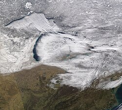
While most commonly associated with the Great Lakes in North America, this process can occur over any large body of water. When it happens over saltwater, it is referred to as ocean-effect or bay-effect snow. The mechanism remains the same: cold air picks up heat and moisture from the water, creating an unstable atmosphere that releases its energy as precipitation once it reaches the downwind shores.
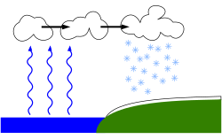
Key Facts
- Formation: Occurs when cold air moves over warmer lake water, picking up moisture and heat.
- Temperature Requirement: Ideally, the air at 1,500 meters (5,000 feet) should be at least 13°C (23°F) colder than the surface air.
- Fetch: A distance of at least 100 km (60 mi) of travel over water is typically required.
- Intensity: Can produce many centimeters of snow per hour, sometimes accompanied by lightning (thundersnow).
- Location: Major hotspots include the Great Lakes (USA/Canada), the Great Salt Lake (USA), the Black Sea (Turkey), and the North Sea (UK).
The Mechanics of Formation
Atmospheric Instability
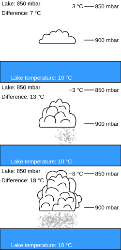
The engine driving lake-effect snow is instability. For vigorous vertical movement of heat and moisture to occur, there must be a significant temperature difference between the lake surface and the upper atmosphere. Specifically, when the air temperature at the 850 millibar pressure level (approximately 1.5 kilometers or 5,000 feet up) is 13°C (23°F) lower than the surface temperature, it creates absolute instability. This allows for taller, thicker clouds and much higher precipitation rates.
The Role of Fetch and Wind Shear
Two critical physical factors determine the strength of a snow event: fetch and wind shear.
- Fetch: This is the distance an air mass travels over the water. A longer fetch allows the air more time to become saturated with water vapor and absorb heat. Generally, a fetch of at least 100 km (60 mi) is necessary, and larger fetches typically result in more snow.
- Wind Shear: This refers to the change in wind direction and speed at different altitudes. Low directional shear (less than 30°) between the surface and the 700 mb altitude level is ideal for creating strong, well-organized snow bands. If the shear is too high (greater than 60°), the event may only produce light flurries.
Orographic Influence
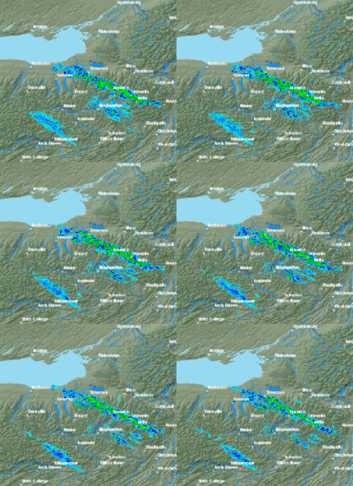
The effect is often intensified by orography—the physical features of the land. When the moisture-laden air reaches the downwind shore and is forced upward by higher elevations, such as hills or plateaus, the air cools and condenses even more rapidly. This can create extremely intense, narrow bands of precipitation.
Global Examples of Lake-Effect Snow
North America: The Great Lakes and Beyond
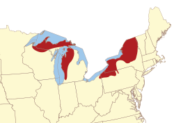
The Great Lakes region is perhaps the most famous location for this phenomenon. The Tug Hill Plateau in New York frequently sets records, receiving over 20 feet of snow annually. In extreme cases, such as in February 2007, North Redfield recorded 141 inches of snow in just 10 days.
Further west, the Great Salt Lake influences the Wasatch Front. Because the lake rarely freezes, it can produce snow year-round. The mountains in this region receive massive amounts of snow, often described as the "Greatest Snow on Earth" due to its light, dry texture.
Eurasia: Turkey and the United Kingdom
In Turkey, the relatively warm waters of the southern Black Sea can trigger significant snowfalls in Istanbul. Despite having winter averages similar to Paris, Istanbul is prone to lake-effect events that can drop over 100 centimeters of snow in a single storm.
In the United Kingdom, a similar phenomenon occurs when cold continental air moves across the North Sea. While technically "sea-effect" snow, it is often locally referred to as lake-effect snow. This has historically caused major disruptions, such as the record-breaking cold event in January 1987.
Summary of Precipitation Factors
| Factor | Requirement for Intense Snow |
|---|---|
| Temperature Gradient | ≥ 13°C (23°F) difference at 850 mb |
| Fetch Distance | Typically ≥ 100 km (60 mi) |
| Directional Shear | < 30° between surface and 700 mb |
| Topography | Higher elevations (orographic lift) enhance intensity |
Frequently Asked Questions
What is the difference between lake-effect snow and lake-effect rain?
The difference depends on the temperature of the air mass. If the air is cold enough to keep the precipitation frozen, it falls as snow; if the temperature is higher, it falls as rain.
Can lake-effect snow cause severe weather like lightning?
Yes. When there is significant instability, the increased energy can produce thundersnow (snow showers accompanied by lightning and thunder). On very rare occasions, it can even lead to tornadoes.
How far from the lake can the snow fall?
Most lake-effect snow typically falls within 40 km (25 mi) of the lake, but it can occasionally reach up to 150 km (100 mi) inland.
Why is the snow in the Great Salt Lake region so different?
Due to the semiarid climate, the snow in the mountains near the Great Salt Lake is often very light and dry, which is why it is highly prized by skiers.
Does the lake have to be frozen for this to work?
No. In fact, the lake must be unfrozen to provide the necessary heat and moisture. A warm water surface is essential to create the temperature instability required for the effect.