Kareli Municipality: A Heartbeat of Georgia's Shida Kartli Region
Nestled in the central heart of Georgia, the Kareli Municipality serves as a vital administrative and cultural hub within the Shida Kartli region. Situated on the fertile Shida Kartli plain, this district blends historical significance with a structured community layout, bridging the gap between the mountainous north and the rolling plains of central Georgia.
Geographically, Kareli is strategically positioned, bordered by the Gori municipality to the east, Khashuri to the west, and Borjomi to the south. This central location makes it a key point of transit and administration within the region.
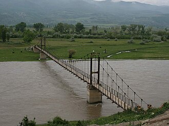
Key Facts
- Region: Shida Kartli, Georgia.
- Total Area: 687.9 km².
- Population: 41,316 (as of 2014).
- Administrative Center: Kareli.
- Composition: 1 town, 1 townlet, and 73 villages.
- Notable Landmark: Mdzovreti fortress.
Geography and Administration
The municipality covers a total area of 687.9 square kilometers (approximately 265.6 square miles). With a population density of 60.06 people per square kilometer, the region maintains a balance between urban centers and rural landscapes. The administrative structure is diverse, consisting of one primary town, one townlet, and 73 distinct villages.
It is important to note that the political geography of the district is complex. Some of the northern territories of the Kareli Municipality are part of the self-proclaimed republic of South Ossetia and have remained outside the control of the Georgian government since 1992.
Education and Culture
Kareli places a significant emphasis on social infrastructure and the preservation of local heritage. The municipality supports a robust educational network designed to serve its diverse population across the town and surrounding villages.
Educational Facilities
The district is equipped with a wide array of learning institutions, including:
- 35 state public schools.
- 1 private school-gymnasium.
- 1 secondary vocational school.
Cultural Preservation
To foster community engagement and historical awareness, the municipality maintains several key cultural assets, including a central library, a dedicated cultural center, and a museum of local lore, which preserves the unique history of the Shida Kartli plain.
Regional Summary
| Category | Detail |
|---|---|
| Country | Georgia |
| Region | Shida Kartli |
| Total Area | 687.9 km² |
| Population (2014) | 41,316 |
| Time Zone | UTC+4 |
| Settlements | 1 town, 1 townlet, 73 villages |
Frequently Asked Questions
Where is Kareli Municipality located?
Kareli Municipality is located in the central part of Georgia, specifically within the Shida Kartli region on the Shida Kartli plain.
What are the bordering municipalities of Kareli?
Kareli is bordered by Gori to the east, Khashuri to the west, and Borjomi to the south.
What is the population of the district?
According to 2014 data, the total population of the Kareli Municipality is 41,316 people.
Are there any historical sites in Kareli?
Yes, the Mdzovreti fortress is a notable historical landmark within the municipality.
What educational resources are available in the municipality?
The area features 35 state public schools, one private school-gymnasium, and one secondary vocational school.