Jeolla Province: A Historical Journey Through Southwestern Korea
Located in the southwestern reaches of the Korean Peninsula, Jeolla Province (Jeolla-do) stands as one of the most historically significant regions in Korean history. Known colloquially as Honam—a term meaning "south of the lake"—this area has served as a vital cultural and administrative hub for centuries. From its origins in the ancient tribal confederacies to its role as one of the Eight Provinces during the Joseon Dynasty, Jeolla has shaped the identity of the nation.
Today, the historical legacy of Jeolla is reflected in the modern administrative divisions of North Jeolla, South Jeolla, Gwangju Metropolitan City, and Jeju Province. As of January 2024, the combined population of the Jeolla region reached 4,973,834.
Key Facts
- Historical Name: Jeolla-do (전라도)
- Common Regional Name: Honam
- Provincial Capital: Jeonju (current capital of North Jeolla)
- Established: The name 'Jeolla-do' was established in 1018 during the Goryeo Dynasty
- Modern Components: North Jeolla, South Jeolla, Gwangju, and Jeju Province
The Evolution of Jeolla: From Ancient Tribes to Unified Silla
The roots of the Jeolla region trace back to the Samhan era, a period of early Korean history characterized by tribal confederacies. During this time, the area was controlled by the Mahan confederacy and the Tamna kingdom on Jeju Island. Of the 45 Korean tribes existing at the time, fifteen were based in this region.
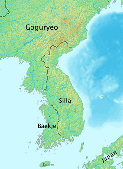
The landscape shifted significantly during the Three Kingdoms era. When the kingdom of Baekje overtook Mahan in the 5th century, the region became part of southern Baekje, with Jungbang serving as the provincial center.
The Silla Reorganization
Following the conquest of Baekje by Silla (with assistance from Tang China) in 660, the territory was integrated into Later Silla. The Silla administration reorganized the land into various administrative units known as ju (provinces) and gyeong (capitals). The former Baekje territories were divided into three ju:
- Ungju: The northern territory, corresponding to modern-day South Chungcheong Province.
- Wansan and Namwon: The middle area, corresponding to modern-day North Jeolla. Wansan was eventually renamed Jeonju.
- Mujin: The southern area, later renamed Mu in 757, corresponding to modern-day South Jeolla.
The Goryeo and Joseon Dynasties
The Goryeo Dynasty saw several administrative shifts. In 983, the country was organized into 12 mok (administrative districts), making Jeonju a Jeonju-mok. By 995, the system changed to 10 do (provinces), creating Gangnam-do and Haeyang-do.
A pivotal moment occurred in 1018, during the 9th year of King Hyeonjong's reign. The provinces of Gangnam and Haeyang were merged to form Jeollaju. This name was a portmanteau of the two principal cities: Jeonju and Naju. This administrative union would remain largely intact for nearly eight centuries.
The Joseon Era and the Eight Provinces
In 1413, during the reign of King Taejong, the territory was reorganized into the Eight Provinces system. While the region was known by various names such as Gwangnam or Jeonnam, the name Jeolla-do eventually became the standard.
The late 19th century brought significant social and political upheaval. The Donghak Peasant Revolution (1894–1895) originated in Jeolla-do. This revolt was driven by protests against high rice taxes imposed by Seoul and rising anti-Japanese sentiment following the Japanese invasions of Korea (1592–1598).
Administrative structures fluctuated briefly in 1895 when King Gojong replaced the province system with 23 districts. However, by 1896, the province system was restored, and Jeolla was officially divided into North Jeolla and South Jeolla provinces.
Geography and Modern Landscape
Geographically, Jeolla is a diverse region bounded by Chungcheong Province to the north, Gyeongsang Province to the east, the East China Sea to the south, and the Yellow Sea to the west. The Sobaek Mountains form its eastern border, while the landscape is drained by the Yeongsan, Seomjin, and Mangyeong rivers.
While Jeonju remains a vital center, Gwangju has grown into the largest city in the region. Other significant urban centers include Iksan, Gunsan, Mokpo, Namwon, Suncheon, and Yeosu.
| Era | Administrative Unit/Name | Key Feature |
|---|---|---|
| Samhan | Mahan / Tamna | Tribal confederacies |
| Three Kingdoms | Southern Baekje | Center at Jungbang |
| Goryeo (1018) | Jeollaju | Union of Jeonju and Naju |
| Joseon | Jeolla-do | Part of the Eight Provinces |
| Modern | North/South Jeolla & Gwangju | Current administrative structure |
Frequently Asked Questions
What does the name "Honam" mean?
Honam is a common term for the inland region of Jeolla, which literally translates to "south of the lake."
When was the name Jeolla-do officially established?
The name was established in 1018 during the 9th year of King Hyeonjong's reign in the Goryeo Dynasty.
What is the capital of Jeolla Province?
Historically, Jeonju served as the provincial capital. In the modern era, Jeonju is the capital of North Jeolla, while Gwangju was the capital of South Jeolla before the capital was moved to Namak in 2005.
Which major rivers flow through the Jeolla region?
The region is primarily drained by the Yeongsan, Seomjin, and Mangyeong rivers.
What was the Donghak Peasant Revolution?
It was a peasant revolt that began in Jeolla-do between 1894 and 1895, fueled by high taxes and anti-Japanese sentiment.