Isle of Orleans: The Historic Territory of New Orleans
Long before the modern boundaries of the United States were established, the region surrounding New Orleans was known as the Isle of Orleans. This historic area, once a vital part of New France in present-day Louisiana, served as a strategic geopolitical piece during the colonial tug-of-war between the great European powers of the 18th century.
Key Facts
- Original Name: Île d'Orléans (French for "Isle of Orleans").
- Primary Location: The area surrounding New Orleans, Louisiana.
- Key Treaties: Transferred via the Treaty of Fontainebleau (1762) and confirmed by the Treaty of Paris (1763).
- Final Status: Incorporated into the United States through the 1803 Louisiana Purchase.
The Colonial Transition: France to Spain
The story of the Isle of Orleans is deeply intertwined with the French and Indian War. By 1762, France anticipated that Great Britain would seize the Louisiana territory upon the war's conclusion. To prevent their rivals from gaining total control, France utilized the Treaty of Fontainebleau to transfer ownership of Louisiana west of the Mississippi River to Spain.
Crucially, France also defined a specific area east of the Mississippi River to be handed to Spain. This newly defined region, which included the city of New Orleans, was designated as the Isle of Orleans.
The Treaty of Paris and British Expansion
The geopolitical shift was formalized in the 1763 Treaty of Paris. As France had predicted, the British took possession of most of Louisiana east of the Mississippi. This land was divided between the new British Province of Quebec to the north and the colony of West Florida to the south, with the latter's capital located at Pensacola.
However, the Isle of Orleans remained an exception. The Treaty of Paris confirmed that Spain would retain possession of both the Louisiana territories west of the Mississippi and the specific enclave of the Isle of Orleans.
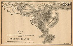
Geography and Boundaries
The Isle of Orleans was not an island in the traditional sense, but a defined territory bounded by several natural landmarks. Its borders were established by the following:
- The Mississippi River to the west.
- The Gulf of Mexico to the south.
- Lakes Pontchartrain and Maurepas to the north.
- The Amite River and Bayou Manchac (formerly known as the Iberville River) to the east.
| Year/Event | Controlling Power | Significance |
|---|---|---|
| Pre-1762 | France | Part of New France in Louisiana. |
| 1762 (Fontainebleau) | Spain | Transferred from France to avoid British seizure. |
| 1763 (Paris) | Spain | Possession confirmed while surrounding lands went to Britain. |
| 1803 | United States | Acquired via the Louisiana Purchase. |
The Path to American Sovereignty
The Isle of Orleans remained under Spanish influence until the early 19th century. In 1803, the territory was included in the Louisiana Purchase, the massive land acquisition that expanded the United States. Shortly thereafter, the region served as the southern border for the Republic of West Florida, a short-lived political entity.
Frequently Asked Questions
Was the Isle of Orleans actually an island?
While the name suggests an island, it referred to the historic New Orleans area bounded by the Mississippi River, the Gulf of Mexico, and various lakes and rivers.
Why did France give the territory to Spain?
France anticipated that Great Britain would take the territory after the French and Indian War and preferred to transfer it to Spain via the Treaty of Fontainebleau.
Which treaty confirmed Spanish possession of the area?
The Treaty of Paris (1763) confirmed that Spain held the Isle of Orleans and the Louisiana territories west of the Mississippi River.
How did the Isle of Orleans become part of the United States?
The territory was included in the Louisiana Purchase of 1803.
What were the eastern boundaries of the Isle of Orleans?
The eastern boundaries were defined by the Amite River and Bayou Manchac, which was previously called the Iberville River.