I-485 and the Stone Mountain Freeway: Atlanta's Great Freeway Revolt
In the mid-20th century, Atlanta's urban landscape was envisioned as a web of high-speed arteries. Among the most ambitious of these were the proposed I-485 and the Stone Mountain Freeway. While these roads were designed to streamline transit across the city, they ultimately became the center of a fierce battle between government planners and local residents, forever changing how Atlanta approaches urban development.
The Vision for a New Freeway System
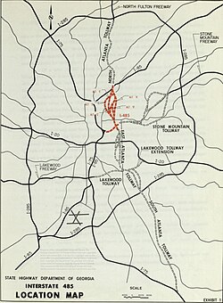
The original blueprints for Atlanta's freeway system included several corridors that were never realized. One primary proposal was a north-south freeway designed to run parallel to the Downtown Connector (I-75/85), situated approximately 2–3 miles (3.2–4.8 km) to the east. This route would have connected the southern terminus of Georgia 400 with I-675 at the southeast Perimeter.
Under this plan, Georgia 400 would have extended south from its current end at I-85 near Lindbergh, cutting through the neighborhoods of Morningside, Virginia-Highland, and Poncey-Highland to reach Copenhill—the location of the present-day Carter Center.
At Copenhill, this north-south route would have intersected with the east-west Stone Mountain Freeway. This second highway was planned to begin in Downtown Atlanta, following the path of today's Freedom Parkway eastward to Copenhill. From there, it would have run parallel to Scott Boulevard and Ponce de Leon Avenue until reaching the northeast Perimeter, where it would transition into the existing Stone Mountain Freeway.
The designation I-485 was intended for two specific segments: the east-west stretch from Downtown to Copenhill and the north-south stretch from Copenhill north to I-85.
The Rise of Neighborhood Resistance
When the Georgia Highway Department (GHD) announced plans for I-485 in 1964, it sparked immediate backlash. In May 1965, the Morningside Lenox Park Association (MLPA) was established specifically to fight the project. The MLPA proposed an alternative "Route E," which would have followed a path roughly along the current BeltLine toward Ansley Mall and then north along Piedmont Road.
However, this alternative was not universally welcomed; the Morningside Monroe Civic Association (MMCA) formed in July 1965 to oppose Route E. By February 1966, the GHD rejected the alternative and reaffirmed its commitment to the original "Route B" through Morningside.
Legal Battles and Political Shifts
The MLPA attempted to halt construction through the courts in October 1966, but their lawsuit and subsequent appeal in June 1967 were denied. Despite these legal setbacks, activists continued to fight. Between 1967 and 1970, the MLPA negotiated design changes with the GHD to delay the project. By 1971, a new lawsuit was filed via a Political Action Committee (PAC), driven by activists Virginia Taylor, Adele Northrup, Mary Davis, and Barbara Ray.
The local struggle was mirrored by national trends. In 1969, Congress passed the National Environmental Policy Act, and the Supreme Court intervened in Tennessee to stop Interstate 40 from cutting through a Memphis park, providing legal and ideological momentum for Atlanta's residents.
The Path to Cancellation
The opposition grew into a broad coalition. In the fall of 1971, Joseph Drolet led the formation of the Virginia Highland Civic Association (VHCA), which joined forces with residents of Inman Park and other affected areas. Political tides began to turn as well:
- November 1971: The Atlanta Board of Aldermen rescinded their support for I-485.
- 1972: Vice-mayor Maynard Jackson opposed the highway during his mayoral campaign.
- June 1973: The Board of Aldermen passed a motion to actively oppose the freeway.
- March 1973: Governor Jimmy Carter signed a new city charter for Atlanta that included an "Environmental Bill of Rights," authored by Adele Northrup.
The final blows came from federal and state authorities. In June 1973, the federal DOT rejected the GHD's environmental impact study, ruling that it had underestimated the damage to intown neighborhoods. Finally, in 1975, Governor George Busbee ordered the GHD to remove I-485 from its long-term plans, effectively ending the project.
Legacy and Lasting Impact
The "freeway revolt" had a profound effect on Atlanta's civic structure, empowering neighborhood organizations to exert significant influence over city planning—a characteristic that persists today. Additionally, land that had been cleared for the highway was repurposed into green spaces, including Sidney Marcus Park in Morningside, John Howell Memorial Park in Virginia Highland, and Freedom Park.
| Feature | North-South Route (I-485 Segment) | East-West Route (I-485/Stone Mountain) |
|---|---|---|
| Starting Point | GA 400 (near Lindbergh) | Downtown Atlanta |
| Key Intersection | Copenhill (Carter Center) | Copenhill (Carter Center) |
| Ending Point | I-675 (Southeast Perimeter) | Stone Mountain Freeway (Northeast Perimeter) |
| Key Opponents | MLPA, VHCA, MMCA | Inman Park and surrounding residents |
Key Facts
- I-485 was planned as a combination of north-south and east-west segments meeting at Copenhill.
- The Morningside Lenox Park Association (MLPA) was a primary force in stopping the highway.
- The project was officially cancelled in 1975 by Governor George Busbee.
- The National Environmental Policy Act of 1969 provided critical legal momentum for the opposition.
- Former razed areas were converted into Sidney Marcus Park, John Howell Memorial Park, and Freedom Park.
Frequently Asked Questions
What was I-485?
I-485 was a proposed interstate highway in Atlanta that would have included a north-south route parallel to the Downtown Connector and an east-west route connecting Downtown to the Stone Mountain Freeway.
Who were the main opponents of the freeway?
The primary opposition came from neighborhood groups, most notably the Morningside Lenox Park Association (MLPA) and the Virginia Highland Civic Association (VHCA), along with residents of Inman Park.
How did the project eventually get stopped?
The project was halted through a combination of grassroots activism, lawsuits, the rejection of an environmental impact study by the federal DOT, and the final decision by Governor George Busbee in 1975 to remove it from long-term plans.
What happened to the land cleared for the highway?
Portions of the right-of-way where homes had been demolished were converted into public parks, including Freedom Park, Sidney Marcus Park, and John Howell Memorial Park.
Did any political figures support the highway?
Yes, Bert Lance, an ally of Governor Jimmy Carter and head of the Georgia DOT from 1971 to 1973, continued to push for the freeway's construction despite growing opposition.