I-391: The Evolution of a Critical Massachusetts Connector
Interstate 391 (I-391) serves as a vital transportation link in Western Massachusetts, facilitating the movement of vehicles between Chicopee and Holyoke. What began as a conceptual improvement to local roads evolved into a high-capacity freeway designed to alleviate congestion and support the growth of the Springfield metropolitan area.
The Origins of I-391
The roots of the highway date back to 1953, when the Master Highway Plan for the Springfield metropolitan area first proposed a "major street improvement" for Route 116. As the region grew throughout the 1960s, it became evident that a more robust solution was required. To improve traffic flow between Chicopee and Holyoke, planners proposed a spur route—a short highway branching off a main interstate—connecting to I-91.
By 1965, engineers had established a primary alignment for the highway, alongside two alternative routes. The project was ambitious, with plans for six lanes capable of handling up to 50,000 vehicles daily. The estimated cost for the proposal was approximately $35 million, which adjusts to roughly $265 million in 2024 currency.
Construction Timeline and Challenges
The path to completion was marked by periods of activity and stagnation. Construction first began in 1967, resulting in the completion of a short 0.75-mile (1.21 km) segment by 1970. However, progress stalled for several years following this initial phase.
Work resumed in 1978, leading to the final completion of the highway in 1982. In total, the project spanned approximately 15 years of planning and construction. Interestingly, the original proposal included an interchange with the Massachusetts Turnpike (I-90) to link the turnpike directly to Chicopee and Holyoke, but this specific connection was never built.
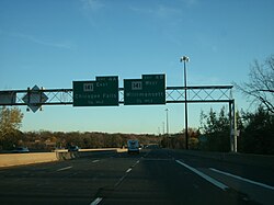
Traffic Growth and Usage
Since its completion, I-391 has seen a steady increase in its Annual Average Daily Traffic (AADT)—a measure of the total volume of vehicle traffic on a highway for a year divided by 365 days. Over nearly four decades, the volume of commuters and travelers has more than doubled.
| Year | AADT (Vehicles) |
|---|---|
| 1982 | 17,200 |
| 1990 | 26,520 |
| 2000 | 31,000 |
| 2010 | 32,578 |
| 2018 | 37,164 |
Key Facts
- Purpose: Built as a spur route of I-91 to connect Chicopee and Holyoke.
- Capacity: Designed with six lanes to accommodate up to 50,000 vehicles per day.
- Cost: Estimated at $35 million at the time of proposal (~$265 million in 2024).
- Timeline: Planning began in 1953; construction occurred in phases (1967–1970 and 1978–1982).
- Traffic Trend: AADT grew from 17,200 in 1982 to 37,164 by 2018.
Frequently Asked Questions
Why was I-391 originally planned?
It originated from a 1953 plan to improve Route 116 and was later developed into a freeway spur to improve traffic flow between Chicopee and Holyoke.
How long did it take to build the highway?
The process took approximately 15 years of combined planning and construction, with the final completion occurring in 1982.
Was the highway connected to the Massachusetts Turnpike?
No. While an interchange with I-90 was part of the original proposal to connect the turnpike to Chicopee and Holyoke, it was never constructed.
What is the current traffic capacity of I-391?
The highway was engineered with six lanes to handle a maximum of 50,000 vehicles every day.
How has traffic volume changed since 1982?
Traffic has increased significantly, rising from an AADT of 17,200 in 1982 to 37,164 in 2018.