Hirson: Geography, Landscape, and Toponymy of the Aisne Region
Nestled in the northeastern reaches of the Aisne department, Hirson serves as a strategic gateway between France and Belgium. As a key part of the Thiérache region, this area is characterized by its lush greenery, intricate water networks, and a unique position bordering the Nord and Ardennes departments.
The town's natural setting is defined by its proximity to two expansive woodlands: the forest of Hirson and the forest of Saint-Michel, which contribute to the region's distinct ecological character.
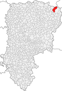
Key Facts
- Location: Northeastern Aisne, France, adjacent to the Belgian border.
- Regional Affiliation: Part of the Thiérache area.
- Elevation: Ranges from a low of 157 meters to a peak of 268 meters above sea level.
- Primary Waterways: The Oise and Gland rivers.
- Etymology: Derived from terms meaning "hedgehog."
Hydrography and Natural Waterways
Hirson is defined by a rich hydrographic network, primarily watered by the Oise and Gland rivers. Beyond these primary arteries, the town is crisscrossed by several smaller streams that shape the local landscape.
These local streams include:
- Stream of Anor
- Stream of Brugnon
- Stream of La Marquette
- Stream of Les Marais
- Stream of Blangy
- Stream of Le Catelet
- Stream of Le Rie De Bon Feu
- Stream of Four Matot
Geology, Relief, and Toponymy
The relief of Hirson is characterized by moderate elevation changes. The town's highest point reaches 268 meters above sea level, while its lowest point descends to 157 meters, creating a varied terrain typical of the northeastern French highlands.
The toponymy—the study of place names—of Hirson reveals an interesting linguistic history. The name is believed to originate from either the Latin word Iricio or the Picard word hirchon, both of which translate to "hedgehog."
Regional Connectivity and Neighbors
Due to its location on the edge of France, Hirson shares borders with several municipalities across different administrative zones, including a direct border with Belgium.
| Country/Department | Municipality |
|---|---|
| France (Aisne) | Éparcy, Buire, Neuve-Maison, Mondrepuis, Saint-Michel, Bucilly |
| France (Nord) | Anor |
| Belgium | Momignies |
Frequently Asked Questions
Where is Hirson located?
Hirson is located in the northeastern part of the Aisne department in France, situated within the Thiérache region and adjacent to the border of Belgium.
What are the primary rivers in Hirson?
The town is primarily watered by the Oise and Gland rivers, supported by a network of eight smaller local streams.
What is the elevation range of the area?
The altitude in Hirson ranges from a minimum of 157 meters to a maximum of 268 meters above sea level.
What does the name "Hirson" mean?
The name is derived from the Latin Iricio or the Picard hirchon, both of which mean "hedgehog."
Which forests are located near Hirson?
Hirson is situated near two large forests: the forest of Hirson and the forest of Saint-Michel.