Hallasan: South Korea's Majestic Shield Volcano and National Treasure
Rising prominently from the center of Jeju Island, Hallasan is more than just a mountain; it is the very soul of the island. As a massive shield volcano—a type of volcano built up by the slow accumulation of fluid lava flows—it forms the bulk of Jeju's landscape. Often cited alongside Jirisan and Seoraksan as one of South Korea's three most significant mountains, Hallasan stands as the highest point in the country, reaching an elevation of 1,947.06 meters (6,388.0 ft).
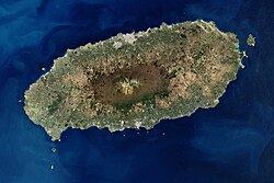
Key Facts
- Location: Jeju Province, South Korea
- Type: Shield volcano
- Highest Elevation: 1,947.06 m (6,388.0 ft)
- Status: Hallasan National Park and South Korean Natural Monument No. 182
- Notable Feature: Baengnokdam crater lake
- Last Recorded Eruption: 1007 CE (classified as active)
Geology and the Formation of Jeju Island
The geological history of Hallasan began during the Pliocene epoch on a continental shelf located approximately 100 meters below sea level. Through successive eruptions of basalt and trachyte (a type of volcanic rock) lava, the island was constructed above sea level. Today, the mountain's soil is composed of volcanic ash, volcanic sand, and lapilli (small fragments of volcanic rock). While this soil boasts higher organic content and better drainage than most areas in South Korea, it remains relatively infertile.
The flanks of the volcano are dotted with approximately 360 oreum, the Jeju term for parasitic cones. These include cinder cones, scoria cones, and lava domes. Additionally, about 20 tuff rings—formed by underwater phreatic eruptions (explosions caused by steam)—can be found near the coast and offshore.
The Mystery of Baengnokdam
At the summit lies the breathtaking Baengnokdam, or "white deer lake." This crater lake was formed by the collapse of the ridge due to underground magma movement. Local legend suggests the name comes from otherworldly beings who descended from heaven to play with white deer in its waters. Depending on the season, the lake can reach a circumference of 2 kilometers and a depth of approximately 100 meters.
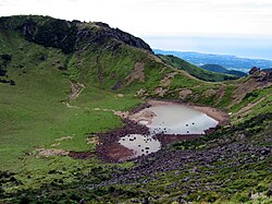
Geologically, the lake's walls are asymmetrical. The eastern wall is covered by a 2–5 meter thick layer of basalt lava and contains stream sediment, suggesting it is a pit crater rather than a standard lava eruption crater. In contrast, the western wall is composed of a trachyte lava dome.
A Unique and Diverse Ecosystem
Because Jeju Island has been isolated from the mainland for millennia, Hallasan has become a sanctuary for unique biological evolution. The dramatic change in elevation creates various climate zones, allowing subtropical plants at the coast to coexist with alpine species at the summit. This environmental gradient supports over 50 unique species found specifically in the high-elevation areas of Jeju.
Flora and Fauna
The mountain is home to a vast array of life, including:
- Plants: A wide distribution of vascular plants, including several species designated as endangered or rare by the Ministry of Environment.
- Birds: 121 bird species inhabit the mountain, with 19 species protected as natural monuments.
- Mammals: While species diversity is lower due to island isolation, the mountain hosts weasels, badgers, and roe deer. Notably, the roe deer population has increased thanks to conservation efforts.
- Insects and Spiders: A staggering 4,300 insect species and 254 spider species reside here.
Climate and Topography
The massive structure of Hallasan significantly influences the local weather on Jeju Island. The mountain acts as a barrier to wind, creating complex patterns such as sea breezes and persistent eddies. These topographical effects can cause significant temperature variations; for instance, the mid-mountainous areas can experience maximum temperatures 1–3 °C higher than coastal areas when winds are weak. Conversely, during strong winds, the mountain can induce much lower minimum temperatures in downwind areas.
Visiting Hallasan: Trails and Culture
For those seeking spiritual or physical adventure, Hallasan offers several distinct hiking paths. It is also home to Gwaneumsa, the oldest Buddhist temple on the island, which dates back to the Goryeo period.
| Trail Name | Length | Access to Summit? |
|---|---|---|
| Gwaneumsa Trail | 8.7 km | Yes |
| Seongpanak Trail | 9.6 km | Yes |
| Eorimok Trail | 4.7 km | No (to Witse Oreum only) |
| Yeongsil Trail | 3.7 km | No (to Witse Oreum only) |
| Donnaeko Trail | 9.1 km | No (to Witse Oreum only) |
Note: The Eorimok, Yeongsil, and Donnaeko trails are restricted to Witse Oreum to protect the mountain's sensitive vegetation.
Frequently Asked Questions
Which trails lead to the summit of Hallasan?
Only the Gwaneumsa Trail and the Seongpanak Trail allow hikers to reach the actual summit and the Baengnokdam crater lake.
Is Hallasan an active volcano?
Yes, it is classified as an active volcano because it has erupted within the last 10,000 years, though some geological evidence suggests its last eruption may have occurred as recently as 1007 CE.
What is an "oreum"?
An oreum is the Jeju dialect term for the approximately 360 parasitic cones found on the flanks of the Hallasan volcano.
How can I reach the hiking trails using public transport?
Accessibility varies by trail. For example, the Seongpanak Trail is highly accessible via buses 181, 182, or 281, which run at frequent intervals (10–15 minutes).
Why is the biodiversity on Hallasan so unique?
The island's long-term isolation from the mainland and the extreme changes in elevation (from subtropical to alpine) have allowed species to evolve independently and created diverse habitats for both polar and tropical animals.