Greater Rio de Janeiro: Brazil's Dynamic Metropolitan Hub
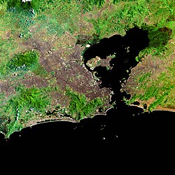
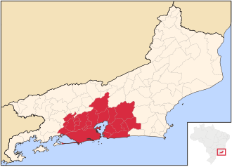
The Greater Rio de Janeiro area, officially known as the Rio de Janeiro Metropolitan Region (Região Metropolitana do Rio de Janeiro), stands as one of the most significant urban agglomerations in the Southern Hemisphere. Located in the state of Rio de Janeiro, Brazil, it is the second-largest metropolitan area in Brazil and the third-largest in South America.
Serving as a vital historical, cultural, and economic center for the nation, the region comprises 22 municipalities, including the state capital, Rio de Janeiro. With a total population of approximately 12 million inhabitants, the region is characterized by its dense urban sprawl and strategic coastal geography.
Regional Evolution and Urban Structure
The metropolitan region was officially established on July 1, 1974, shortly before the fusion of Guanabara into Rio de Janeiro. Over the decades, the region's boundaries have been fluid, with adjustments made in 1993, 2001, 2002, 2009, 2013, and 2018 to include or remove various cities.
A defining feature of the area is its high level of conurbation—a process where separate urban areas merge into one continuous built-up area. This is most evident in the seamless transition between Rio de Janeiro and the Baixada Fluminense, as well as between Niterói and São Gonçalo.
Infrastructure and Connectivity
To support its massive population, Greater Rio de Janeiro utilizes a highly interconnected transportation network. Most regional transit is integrated with the capital's inner-city systems, including the metro, trains, and buses.
- Roadways: Major inter-city freeways facilitate movement, including the Rio–Niterói Bridge, the Red Line, the President Dutra freeway, and the Niterói-Manilha freeway.
- Rail and Bus: Urban intermunicipal buses connect all 22 municipalities, while trains link the capital to several cities in the Baixada Fluminense.
- Maritime: Ferry boats provide essential transit to municipalities located across the Guanabara Bay.
Additionally, the region maintains coordinated water supply plans to ensure resource management across the various municipal borders.
Key Facts
- Total Population: 12,022,050 (2022 Census).
- Composition: 22 municipalities.
- Economic Power: Nominal GDP of R$ 413.93 Billion.
- Primary Hub: Rio de Janeiro city is the most populous and has the largest GDP (R$ 282.5 billion).
- Quality of Life: Niterói holds the highest Human Development Index (HDI) in the region at 0.837.
Demographics and Economic Data
The distribution of the population is heavily weighted toward the capital, though several satellite cities maintain significant populations. The following table provides a detailed breakdown of the region's municipalities based on the most recent census data.
| Municipality | Area (km²) | Population (2022) | Density (pop/km²) |
|---|---|---|---|
| Rio de Janeiro | 1,221.000 | 6,211,423 | 5,087.16 |
| São Gonçalo | 249.143 | 896,744 | 3,599.31 |
| Duque de Caxias | 464.573 | 808,152 | 1,739.56 |
| Nova Iguaçu | 520.807 | 785,822 | 1,508.85 |
| Belford Roxo | 79.791 | 483,087 | 6,054.40 |
| Niterói | 129.375 | 481,758 | 3,723.73 |
| São João de Meriti | 34.838 | 440,962 | 12,657.50 |
| Petrópolis | 795.798 | 278,881 | 350.44 |
| Magé | 385.700 | 228,127 | 591.46 |
| Itaboraí | 430.375 | 224,267 | 521.10 |
Frequently Asked Questions
How many municipalities make up Greater Rio de Janeiro?
The metropolitan region consists of 22 municipalities, including the state capital, Rio de Janeiro.
What is the total population of the region?
According to the 2022 Census, the total population of the Rio de Janeiro Metropolitan Region is 12,022,050 inhabitants.
Which city has the highest quality of life in the region?
Based on 2010 estimates, Niterói has the highest Human Development Index (HDI) in the region, with a score of 0.837.
What are the main transportation links in the area?
The region is connected via intermunicipal buses, trains, ferry boats across Guanabara Bay, and major freeways such as the Rio–Niterói Bridge and the President Dutra freeway.
What does conurbation mean in the context of Rio?
Conurbation refers to the merging of separate cities into one continuous urban area. In this region, it is most visible between Rio de Janeiro and Baixada Fluminense, and between Niterói and São Gonçalo.