Greater Buenos Aires: Argentina's Massive Metropolitan Hub
Greater Buenos Aires (Spanish: Gran Buenos Aires, GBA), also widely known as the Buenos Aires Metropolitan Area (Área Metropolitana de Buenos Aires, AMBA), is one of the most significant urban agglomerations in the Southern Hemisphere. It is not a single administrative entity but a vast network comprising the Autonomous City of Buenos Aires (CABA) and the surrounding 24 partidos (counties) within the Province of Buenos Aires.
This expansive urban region, often referred to colloquially as the Conurbano Bonaerense, serves as the economic and political heart of Argentina. While the city of Buenos Aires acts as the core, the conurbation spreads north, south, and west, bounded to the east by the natural barrier of the River Plate.
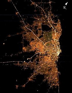
Key Facts
- Total Metro Population: Approximately 13,985,794 (including CABA and 24 partidos).
- Economic Power: Generates nearly 48% of Argentina's total GDP.
- Land Area: Covers roughly 3,833 km².
- Population Share: Home to about one-third of Argentina's total population.
- GDP per Capita: $15,200 (2023).
- Core City: Buenos Aires (CABA).
The Evolution of the Metropolitan Area
The official designation of "Gran Buenos Aires" dates back to 1948, when Governor Domingo Mercante signed a bill defining the area as 14 municipalities surrounding the capital. Between 1945 and 1980, the region experienced rapid urban sprawl—the uncontrolled expansion of urban areas—resulting in a metropolitan footprint 19 times larger than that of Buenos Aires proper.
Population growth in the suburban partidos was aggressive during the mid-20th century, growing at nearly 2.5% annually between 1947 and 2022, significantly outpacing the national average of 1.4%. Although growth slowed to 0.8% between 2010 and 2022, the region remains a powerhouse of density and productivity.
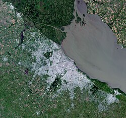
Defining the Conurbation
The National Institute of Statistics and Censuses (INDEC) categorizes the metropolitan area into three distinct groups based on their level of urban integration:
1. Fully Urbanized Partidos
These 14 counties are completely integrated into the urban fabric. They include Avellaneda, General San Martín, Hurlingham, Ituzaingó, José C. Paz, Lanús, Lomas de Zamora, Malvinas Argentinas, Morón, Quilmes, San Isidro, San Miguel, Tres de Febrero, and Vicente López.
2. Partially Urbanized Partidos
Ten counties are considered partially urbanized: Almirante Brown, Berazategui, Esteban Echeverría, Ezeiza, Florencio Varela, La Matanza, Merlo, Moreno, San Fernando, and Tigre.
3. Emerging Metropolitan Areas
In 2006, Law 13473 expanded the metropolitan definition to include six additional partially urbanized partidos: Escobar, General Rodríguez, Marcos Paz, Pilar, Presidente Perón, and San Vicente. Furthermore, for statistical purposes, the 2022 Census included outlying areas such as Brandsen, Campana, Cañuelas, Exaltación de la Cruz, Luján, and Zárate.
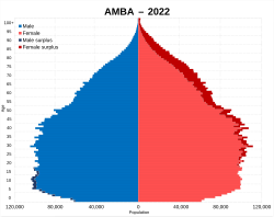
Demographics and Infrastructure
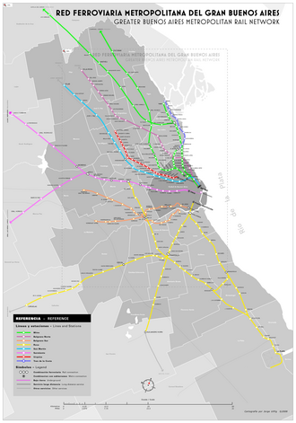
The distribution of the population is heavily skewed toward the core and the most populous suburbs. La Matanza stands as the most populous suburb in the region. The connectivity of these diverse zones is maintained by an extensive rail network that links the outlying partidos to the central business district of CABA.
The following table summarizes the key demographic and economic metrics of the metropolitan area:
| Metric | Value | Notes |
|---|---|---|
| Metro Area | 3,833 km² | Approx. 1,480 sq mi |
| Metro Population | 13,985,794 | CABA + 24 partidos (2022 Census) |
| Metro Density | 3,926.1/km² | 10,169/sq mi |
| Metro GDP (2023) | $235.6 Billion | 48% of national GDP |
| GDP Per Capita (2023) | $15,200 | Average per person |
Frequently Asked Questions
What is the difference between CABA and the Conurbano?
CABA (Ciudad Autónoma de Buenos Aires) is the autonomous federal capital city, while the Conurbano refers to the surrounding 24 or more partidos in the Province of Buenos Aires that form the wider metropolitan area.
Which is the most populous suburb in Greater Buenos Aires?
La Matanza is the most populous suburb, with a population of 1,837,774 according to the 2022 Census.
What does AMBA stand for?
AMBA stands for Área Metropolitana de Buenos Aires, which is the Spanish term for the Buenos Aires Metropolitan Area.
How much of Argentina's economy is generated in Greater Buenos Aires?
The metropolitan area is an economic powerhouse, generating nearly 48% of the entire country's GDP.
How has the population grown in the suburban areas?
Between 1947 and 2022, the population of the 24 suburban partidos grew more than sixfold, reflecting a long-term trend of urban expansion away from the city center.