Glenurquhart: A Scenic Highland Glen in Scotland
Located within the Highland council area of Scotland, Glenurquhart (Scottish Gaelic: Gleann Urchadain) is a picturesque glen that stretches west from the village of Drumnadrochit. This region is characterized by its dramatic landscapes, rich history, and deep connection to the natural beauty of the Highlands.
Geography and Location
Glenurquhart extends from Urquhart Bay on the shores of Loch Ness in the east to Corrimony and beyond toward the west. The River Enrick flows along the length of the glen, passing through Loch Meiklie. Approximately five miles (eight kilometres) into the glen, visitors will find the villages of Balnain and Balbeg.
Key Facts
- Location: West of Drumnadrochit, Highland council area, Scotland.
- Waterways: The River Enrick and Loch Meiklie.
- Climate: Oceanic (Köppen: Cfb), featuring snowy winters and sunny summers.
- Key Landmarks: Corrimony chambered cairn and Craigmonie woodland.
- Local Sport: Home to the Glenurquhart Shinty Club.
History and Notable Figures
Historically, the lands of Glenurquhart were once held by the Grants of Glenmoriston, while the lands to the north were primarily held by the Frasers.
The region has been home to several distinguished individuals:
- Fr. Alexander MacDonnell (1763-1840): The first Roman Catholic priest to serve as a military chaplain in post-Reformation British military history and the first Bishop of the Diocese of Kingston, Ontario.
- The Rev. Ewen MacRury (1891–1986): A minister of Glen Urquhart from approximately 1930 to the 1960s, who served as the Moderator of the General Assembly of the Free Church of Scotland in 1944.
- Allan Wilson (1856–1893): An officer in the Victoria Volunteers known for leading the Shangani Patrol during the First Matabele War. He became a national hero in Britain and Southern Rhodesia following his death in battle.
Climate and Environment
The area around Inverness, including Glenurquhart, experiences an oceanic climate (Köppen classification: Cfb). This results in pleasantly warm and sunny conditions during the spring and summer, while autumn is typically cool and rainy. Winters are very cold and snowy, occasionally bringing blizzards.
The volatility of the weather was evident in November 2010, when landslips and fallen trees caused significant disruptions on the A82 near Drumnadrochit, leading police to impose speed restrictions on several bridges.
Attractions and Recreation
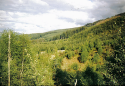
Glenurquhart offers a diverse landscape of native broadleaved woodlands and planted conifer forests. The southern hillsides are primarily dedicated to commercial forestry managed by the Forestry Commission. In contrast, the opposite slopes feature a blend of farmland, commercial forestry, and deciduous woodland, dominated by birch trees.
For those seeking outdoor activities, the region provides:
- Waymarked Walks: Available in the Craigmonie woodland near the foot of the glen.
- Forest Roads: A network of roads suitable for cycling, horse-riding, and walking.
- Deer Stalking: A popular cultural and recreational activity that attracts international visitors.
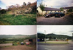
![4 images of Drumnadrochit in 1998. The school is top right.[1]](/images/ce/50/ce50266832f147c0d6e03e423b292ebd38ea85ce503c609223d897de8a86dc7a.jpg)
History enthusiasts can visit the Corrimony chambered cairn, a Bronze Age burial monument located west of the village and part of the Clava group of cairns.
| Category | Details |
|---|---|
| Primary River | River Enrick |
| Key Villages | Balnain, Balbeg, Drumnadrochit |
| Forestry Types | Conifer (commercial) and Deciduous (mainly birch) |
| Archaeological Site | Corrimony chambered cairn (Bronze Age) |
| Local Sport | Shinty |
Frequently Asked Questions
Where is Glenurquhart located?
Glenurquhart is located in the Highland council area of Scotland, running west from Urquhart Bay at Loch Ness to Corrimony.
What is the climate like in the Glenurquhart area?
The area has an oceanic climate, characterized by warm, sunny summers and very cold, snowy winters with occasional blizzards.
What can visitors do for outdoor recreation in the glen?
Visitors can enjoy waymarked walks in Craigmonie woodland, use the forest road network for cycling and horse-riding, or participate in deer stalking.
What is the Corrimony chambered cairn?
It is a Bronze Age burial monument located west of the village and is part of the Clava group of cairns.
Which sports team represents the area?
The local shinty team is the Glenurquhart Shinty Club.