Understanding Freezing Rain: Mechanisms, Hazards, and Observations
While snow and sleet are common winter sights, freezing rain presents a unique and often dangerous meteorological phenomenon. Unlike a mixture of ice pellets or snow, freezing rain consists entirely of liquid droplets. However, these droplets possess a deceptive quality: they remain liquid even as they fall through subfreezing air, only to freeze instantly upon contact with any surface they touch.
This process creates a smooth, heavy coating known as glaze ice. When these events occur on a large scale, they are classified as ice storms, which can lead to significant infrastructure damage, power outages, and life-threatening conditions for travelers and aviators alike.
Key Facts
- Composition: Freezing rain is made of liquid droplets, not ice pellets or snow.
- Supercooling: Droplets remain liquid below 0°C (32°F) until they hit a surface.
- Glaze Ice: The resulting ice coating is smooth and conforms to the shape of objects.
- Meteorological Code: In METAR weather reports, freezing rain is identified by the code FZRA.
- Primary Hazard: The weight of accumulating ice can snap tree limbs and downed power lines.
How Freezing Rain Forms
The Melting Mechanism
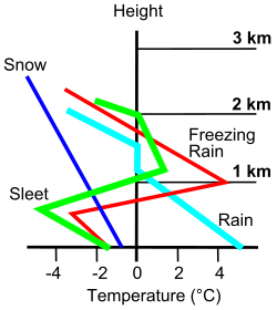
Freezing rain is typically associated with an approaching warm front. This setup often involves cold-air damming, where cold, dry air is trapped near the ground by a high-pressure system, while warmer air moves in aloft.
The process generally follows these steps:
- Snow falls from higher altitudes and encounters a layer of warm air (often around the 800 mbar level).
- The snow melts completely, turning into rain.
- The raindrops fall into a shallow layer of subfreezing air just above the ground.
- If the subfreezing layer is deep, the drops may freeze into ice pellets (sleet). However, if the layer is shallow, the drops remain liquid as supercooled droplets.
When these supercooled drops strike a surface at or below 0°C, they undergo nucleation—a physical process where the liquid instantly begins to freeze, creating a thin film of ice.
The Supercooled Warm-Rain Process
Beyond the melting snow model, scientists have identified a "supercooled warm-rain process." In this scenario, liquid droplets form and remain unfrozen in the atmosphere until they make contact with a surface, at which point they freeze immediately.
Observing Freezing Rain with Radar
It is important to note that weather radar cannot directly "see" freezing rain; it can only detect the intensity of echoes (reflectivity) produced by precipitation. Because rain has a higher reflective power than snow, radar can provide clues about the weather type.
A critical indicator for meteorologists is the brightband. This is a layer in the radar data where melting is occurring. The height and slope of this brightband help forecasters determine if snow is melting into rain and whether that rain might encounter a freezing layer near the surface.
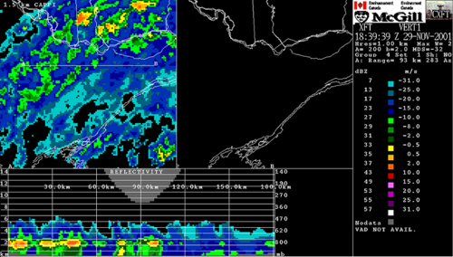
Modern dual-polarized radar technology further assists in these observations. By sending out both vertical and horizontal waves, meteorologists can analyze the shape of the precipitation targets to indirectly deduce whether the storm consists of rain, snow, or a mixture.
The Impact of Ice Accumulation
Ground-Level Hazards
The primary danger at ground level is the weight of the glaze ice. While light freezing rain may only cause minor issues, heavy accumulation is destructive. When ice thickness exceeds approximately 6.4 mm (0.25 in), the weight can cause tree limbs to snap. This often leads to power outages as branches fall onto electrical lines, or as the weight of the ice itself breaks insulators and support poles.
For motorists, freezing rain is exceptionally hazardous. Unlike snow, which may provide some texture, wet glaze ice provides almost no traction, making vehicles prone to sliding even on very gentle slopes.
Aviation Risks
For aircraft, freezing rain is an extreme hazard due to structural icing. As ice accumulates on the wings, it changes the shape of the airfoil (the wing profile). This modification reduces lift and increases drag, which increases the aircraft's stalling speed and makes it difficult to maintain altitude.
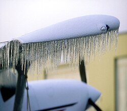
Aviation safety is complicated by the fact that freezing rain is often accompanied by a temperature inversion (where air gets warmer as you go higher). This means that instead of descending into warmer air to escape the ice, pilots may be forced to climb, which is difficult when the aircraft's performance is already compromised by ice.
The "Ghost Apple" Phenomenon
In rare instances, freezing rain creates unusual visual effects. In Michigan in 2019, observers noted "ghost apples"—icy shells left behind when rotting apples defrosted and slipped out from under a layer of ice. A similar effect was seen when a vehicle left behind an ice sculpture of its own front end.
Summary of Precipitation Types
| Precipitation Type | State at Contact | Primary Characteristic |
|---|---|---|
| Snow | Solid | Ice crystals or flakes. |
| Sleet | Solid | Ice pellets that form when rain freezes in a deep subfreezing layer. |
| Freezing Rain | Liquid (Supercooled) | Liquid drops that freeze instantly upon contact with surfaces. |
| Glaze Ice | Solid | The smooth, heavy coating produced by freezing rain. |
Frequently Asked Questions
What is the difference between sleet and freezing rain?
The main difference is the state of the precipitation when it hits the ground. Sleet consists of ice pellets that have already frozen into solid chunks while falling through the air. Freezing rain is liquid when it hits a surface, at which point it freezes into a glaze.
Why is freezing rain so dangerous for airplanes?
Freezing rain causes rapid ice buildup on the wings. This changes the shape of the airfoil, which reduces lift and increases drag, making it much harder for the plane to fly or climb.
What causes an "ice storm"?
An ice storm is a large-scale weather event characterized by significant accumulation of glaze ice from freezing rain, often leading to widespread damage to trees and power lines.
Can radar see freezing rain directly?
No. Radar detects reflectivity, which is influenced by the size and shape of precipitation. Meteorologists must use indirect clues, such as the "brightband" (the melting layer) and dual-polarization data, to identify freezing rain.
What is "supercooled" water?
Supercooled water refers to liquid water that remains in a liquid state even though its temperature has dropped below the freezing point (0°C or 32°F). It only turns to ice when it undergoes nucleation upon hitting a surface.