Freeway Gaps: Where the US Interstate System Breaks Standard
The United States Interstate Highway System is designed to provide high-speed, controlled-access travel across the country. By definition, a freeway should have no traffic lights, no intersections at the same level, and a divided median to ensure safety and efficiency. However, there are several freeway gaps—sections where a route is signed as an Interstate but fails to meet these rigorous engineering standards.
These gaps occur for various reasons, ranging from dense urban development and historical preservation to environmental protections and the sheer cost of construction in rural areas. From drawbridges that halt traffic for ships to surface streets with stop signs, these anomalies provide a fascinating look at the compromises made in American infrastructure.
Key Facts
- Freeway Gaps are sections of signed Interstates that do not meet full freeway standards, such as those featuring at-grade intersections or movable bridges.
- At-grade intersections occur in urban areas due to existing buildings or in rural areas to provide essential property access.
- Movable bridges (drawbridges) are a specific type of gap because they interrupt the continuous flow of traffic.
- I-93 in New Hampshire contains the only remaining multi-mile section of two-lane freeway on the Interstate system.
- Indirect connections occur when two Interstates cross or run near each other without a direct freeway-to-freeway interchange.
At-Grade Intersections
Major Urban Intersections
In heavily developed cities, Interstates sometimes travel along surface roads or feature traffic lights. This typically happens when construction begins after the surrounding land is already occupied by businesses and residences, making the demolition required for full interchanges prohibitively expensive.
Notable examples include I-19 in Nogales, Arizona, which consists of surface streets with traffic lights to direct traffic from Mexico, and I-78 in Jersey City, New Jersey, which utilizes a one-way pair of surface streets with four signalized intersections.
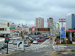
One of the most famous gaps is found on I-70 in Breezewood, Pennsylvania. Here, traffic must exit the Pennsylvania Turnpike and travel along US 30 to continue on I-70. This gap exists because the original Interstate Highways act did not fund direct connections between Interstates and tolled roads. While local businesses have lobbied to keep this gap, the Pennsylvania Turnpike plans to close it by September 2024, with full completion expected in 8 to 10 years.
Minor Rural Intersections
In rural regions, minor at-grade intersections—including median breaks—are more common. These often provide access to farm roads, utility stations, or maintenance driveways where building a full interchange would be too costly for the low volume of traffic.
Examples include I-10 in Hudspeth County, Texas, which has at least fifteen such intersections, and I-40 in western Texas, which features eight access points for cattle ranches. In Washington, the northbound lanes of I-5 feature an at-level crosswalk near the Canadian border to allow pedestrians access to Peace Arch Park.
Undivided and Narrow Freeways
While most Interstates are multi-lane and divided, some sections are narrow or undivided. This includes "super twos"—two-lane divided parkways—and bridges with minimal separation between opposing lanes.
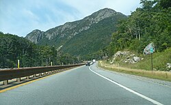
I-93 through Franconia Notch in New Hampshire is a prominent example. This 7.6-mile stretch remains a two-lane freeway due to environmental concerns and the need to protect the Old Man of the Mountain rock formation. It is currently the only multi-mile two-lane section remaining on the system.
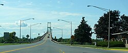
Other narrow sections include the Thousand Islands Bridge on I-81, which is an undivided two-lane road.
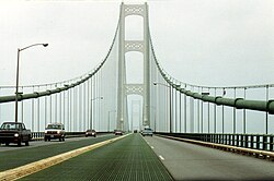
The Mackinac Bridge on I-75 is another unique case. Due to space constraints, it has no hard shoulders and only a 4-inch-high divider or a double-yellow line between directions. Consequently, speed limits are reduced to 45 mph for cars and 20 mph for trucks.
Movable Bridges
Standard Interstate design requires fixed bridges to prevent traffic interruptions. However, several Interstates utilize movable bridges, such as vertical-lift or bascule (draw) bridges, to allow maritime vessels to pass.
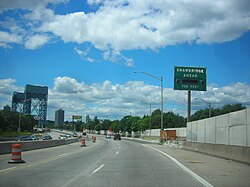
The Stickel Memorial Bridge on I-280 in New Jersey is a vertical-lift bridge crossing the Passaic River. Similarly, the Woodrow Wilson Bridge (I-95/I-495) uses a double-leaf bascule span, though its high vertical clearance limits openings to roughly 65 per year.
Freeway-to-Freeway Connection Gaps
Occasionally, two Interstates cross or run parallel without a direct interchange, forcing drivers to use surface roads or other highways to transition between them. For instance, I-271 in Ohio lacks a direct connection to the Ohio Turnpike (I-80), requiring drivers to use I-77 or State Route 8.
Other examples include I-90 passing over I-391 in Massachusetts without an interchange, and I-81 connecting to the Pennsylvania Turnpike (I-76) via a 1.11-mile stretch of US 11 in Carlisle, Pennsylvania.
| Interstate | Location | Gap Type | Reason/Detail |
|---|---|---|---|
| I-70 | Breezewood, PA | At-grade/Surface | Lack of funding for toll road connections |
| I-93 | Franconia Notch, NH | Two-lane Freeway | Environmental protections |
| I-75 | Mackinac Bridge, MI | Undivided/Narrow | Space constraints on bridge |
| I-280 | Passaic River, NJ | Movable Bridge | Maritime vessel access |
| I-78 | Jersey City, NJ | Surface Streets | Dense urban development |
Frequently Asked Questions
What exactly is a freeway gap?
A freeway gap is a section of a highway signed as an Interstate that does not meet the official freeway standards, such as having traffic lights, at-grade intersections, or undivided lanes.
Why are there traffic lights on some Interstates?
Traffic lights usually appear in urban areas where the highway was built after the land was already developed, making it impossible to build interchanges without destroying existing buildings, or in specific cases like Breezewood, PA, due to historical funding restrictions.
Are all drawbridges on Interstates considered gaps?
Yes, because Interstate standards require bridges to be fixed to ensure the continuous flow of traffic. Any bridge that must open for vessels interrupts this flow.
Is I-93 in New Hampshire still an Interstate if it only has two lanes?
Yes. The Federal Highway Act of 1973 specifically exempts the 7.6-mile stretch through Franconia Notch from standard Interstate requirements, allowing it to be officially signed as I-93.
Why do some Interstates have dirt road intersections?
In rural areas, these are often provided to maintain access to farms or utility stations where the cost of building a full interchange or frontage road is not justified by the low traffic volume.