Elevation: Defining Height, Topography, and Geographic Data
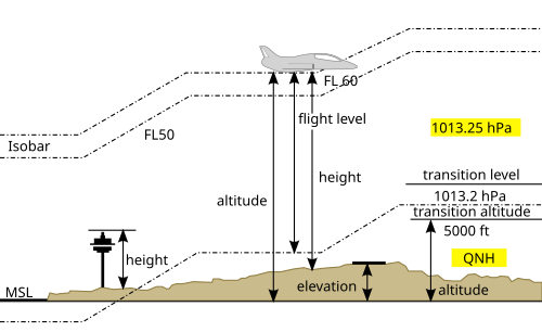
In geography and science, the term elevation refers to the height of a specific location relative to a fixed reference point. While we often use "height" and "elevation" interchangeably in casual conversation, scientific precision requires a distinction between elevation, altitude, and depth. Understanding these nuances is essential for fields ranging from aviation to advanced cartography.
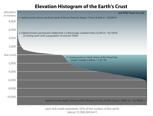
Most commonly, elevation is measured against a geoid. A geoid is a mathematical model representing the Earth's sea level as an equipotential gravitational surface. This serves as the baseline for determining how high or low a point sits on the Earth's surface.
Key Facts
- Elevation refers to points on the Earth's surface relative to a reference geoid.
- Altitude or geopotential height is used for points above the surface, such as aircraft or spacecraft.
- Depth is the term used for points located below the surface.
- Elevation is distinct from the distance from the Earth's center; Mount Everest has the highest elevation, but Chimborazo has the largest geocentric distance due to the equatorial bulge.
- In aviation, aerodrome elevation is defined as the highest point of a landing area.
Elevation vs. Geocentric Distance
It is a common misconception that the highest elevation is always the point furthest from the center of the Earth. Because the Earth is not a perfect sphere and possesses an equatorial bulge, the geometry of the planet changes the results. For example, while Mount Everest reaches the highest elevation above sea level, the summit of Mount Chimborazo is actually the point with the largest geocentric distance (the distance from the Earth's center).
Elevation in Aviation
For pilots and aviation professionals, precision is a matter of safety. The International Civil Aviation Organization (ICAO) defines aerodrome elevation specifically as the highest point of the landing area. This measurement is frequently recorded in feet and is a critical component of airport approach charts. It is important for aviators to distinguish aerodrome elevation from altitude or height to ensure accurate navigation and landing procedures.
Mapping and Geographic Information Systems (GIS)
To visualize the complex textures of our planet, scientists use Geographic Information Systems (GIS). A GIS is a computer-based system designed to capture, store, manipulate, and visualize data associated with specific geographic attributes. These systems allow researchers to identify patterns and relationships within landscapes across various scales.
Digital Models of Terrain
In modern cartography, elevation is represented through several digital methods:
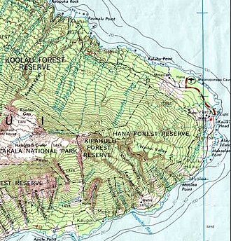
- Topographical Maps: These use contour lines to depict changes in elevation on a 2D surface.
- Digital Elevation Models (DEM): Used within GIS, a DEM represents the surface of a location through a raster (grid) dataset of elevation values.
- Digital Terrain Models: Another method used in GIS to represent the physical terrain of an area.
The 3D Elevation Program (3DEP)
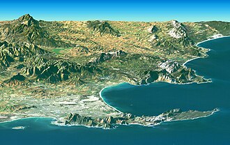
To meet the increasing demand for high-quality topographic data, the United States Geological Survey (USGS) is developing the 3D Elevation Program (3DEP). This initiative provides enhanced elevation data using high-quality LiDAR (Light Detection and Ranging) technology across the conterminous United States, Hawaii, and U.S. territories. The program includes three seamless bare earth DEM layers at resolutions of 1/3, 1, and 2 arcseconds.
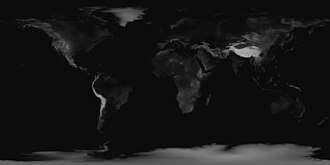
Summary of Elevation Terminology
| Term | Context of Use | Reference Point |
|---|---|---|
| Elevation | Points on the Earth's surface | Reference geoid (sea level) |
| Altitude | Points above the surface (aircraft/spacecraft) | Surface or reference level |
| Depth | Points below the surface | Surface level |
| Aerodrome Elevation | Aviation landing areas | Highest point of the landing area |
Frequently Asked Questions
What is the difference between elevation and altitude?
Elevation is typically used to describe the height of a point on the Earth's surface relative to a reference like sea level. Altitude is generally used to describe the height of objects above the surface, such as an airplane in flight.
Why is Mount Chimborazo considered further from the Earth's center than Mount Everest?
This is due to the Earth's equatorial bulge. Because the Earth is not a perfect sphere, the distance from the center to the surface is greater near the equator, placing Chimborazo further from the center despite Everest having a higher elevation above sea level.
What is a geoid?
A geoid is a mathematical model of the Earth's sea level. It acts as an equipotential gravitational surface, providing a consistent reference point for measuring elevation.
How is elevation shown on a map?
On traditional topographical maps, elevation is often shown using contour lines. In digital systems like GIS, it is represented using Digital Elevation Models (DEM), which use a grid of data points to show terrain.
What is LiDAR in the context of elevation?
LiDAR is a remote sensing technology used by programs like the USGS 3DEP to collect high-quality, high-resolution elevation data by using light to measure distances to the Earth's surface.