El Alto: The World's Highest Major City
Perched on the rugged Altiplano highlands of Bolivia, El Alto (Spanish for "The High One") is a city of extremes. Known in Aymara as Patamarka, it holds the distinction of being the highest major city in the world, with an average elevation of 4,000 meters (13,123 feet). Adjacent to the administrative capital of La Paz, El Alto has evolved from a small railway settlement into one of Bolivia's fastest-growing urban centers.
Today, El Alto is a vibrant hub of commerce and culture, characterized by its unique architectural identity and its role as a gateway to the Andes. Together with La Paz, Achocalla, Viacha, and Mecapaca, it forms the most populous metropolitan area in Bolivia, housing approximately 2.2 million people.
Key Facts
- Elevation: Average of 4,000 m (13,123 ft), reaching up to 4,300 m.
- Population: 885,035 (2024 census) for the city and municipality.
- Global Rank: The highest major city in the world.
- Architecture: Famous for the indigenous Neo-Andean style.
- Connectivity: Linked to La Paz via the Mi Teleférico cable car system.
History and Urban Growth
The plains above La Paz remained largely uninhabited until 1903, when railways from Arica and Lake Titicaca reached the canyon rim. This led to the establishment of railyards, depots, and a settlement for railway workers. The city's growth accelerated in 1925 with the construction of an airfield for the air force, and again in the 1950s when the city was finally connected to the water supply of La Paz.
Politically, El Alto separated from the City of La Paz in March 1985, a date now celebrated as its founding day. It was formally incorporated as a city in 1987. Much of the city's recent expansion has occurred through informal settlements, driven by rural migrants fleeing crop failures and seeking economic opportunities in the urban center.
Infrastructure Challenges
Rapid growth has outpaced the development of basic utilities. Many outlying areas still struggle with substandard infrastructure, including a lack of potable water and connected sewage systems. To combat this, sustainable urban development projects supported by the World Bank and the Inter-American Development Bank (IDB) are currently underway.
Geography and Climate
Located in the Pedro Domingo Murillo Province, El Alto sits on the Altiplano, a high-altitude plateau. The city hosts the El Alto International Airport, serving as a critical transport link for the region.
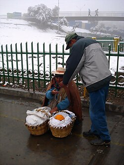
The climate is classified as a cold subtropical highland climate. Due to the thin atmosphere and high elevation, the city experiences significant radiative heat loss, meaning days are typically cool while nights are crisp and often drop below 0 °C. Snowfall can occur at any time of the year.
Environmental challenges are mounting; shrinking glaciers have led to severe droughts. In 2016, the city's three primary dams nearly ran dry due to the lack of glacial meltwater.
| Metric | Warmest Month (Nov) | Coldest Month (Jul) | Annual Average |
|---|---|---|---|
| Mean Daily Max Temp | 17.0 °C (62.6 °F) | 15.3 °C (59.5 °F) | ~14-15 °C |
| Mean Daily Min Temp | 3.6 °C (38.5 °F) | -3 °C (27 °F) | ~4-8 °C |
| Average Precipitation | 50.5 mm | 7.1 mm | 602.5 mm |
Culture and Attractions
El Alto is globally recognized for its Neo-Andean architecture, which emerged in the mid-2000s. This style blends modern construction with traditional indigenous motifs, resulting in colorful, futuristic buildings known as cholets.
Other notable points of interest include:
- Museo de Arte Antonio Paredes Candia: An art museum opened in 2002.
- 16 de Julio Street Fair: A massive open-air market and commercial hub.
- Mi Teleférico: The elaborate cable car system that provides a scenic and efficient commute to central La Paz.
Government and Administration
El Alto is a municipality governed by an executive branch, led by a Mayor elected every five years, and a legislative branch consisting of an 11-member municipal council. As of May 4, 2026, the city is led by Mayor Eliser Roca. The local government often operates alongside the Fejuve, a highly successful grassroots movement that participates in providing security and public services.
Frequently Asked Questions
What is the elevation of El Alto?
El Alto has an average elevation of 4,000 meters (13,123 feet), with some areas reaching up to 4,300 meters (13,615 feet), making it the highest major city in the world.
What is Neo-Andean architecture?
Neo-Andean architecture is a locally indigenous style that appeared in the mid-2000s, characterized by vibrant colors and futuristic designs that incorporate traditional Andean cultural elements.
How is El Alto connected to La Paz?
The two cities are connected by the Mi Teleférico cable car system, which consists of three lines that ease transportation into the economic center of the metropolitan area.
Why is the city growing so rapidly?
Growth is primarily driven by immigration from rural areas of Bolivia, often caused by the difficulty of growing crops in the countryside due to climate changes.
What are the main environmental threats to the city?
The city faces significant water security issues due to shrinking glaciers and drought, as well as water pollution caused by industrial activities such as slaughterhouses and tanneries.