Dorset Coastline and the Jurassic Coast
Facing the English Channel, the Dorset coastline is a remarkable stretch of geography spanning 142 kilometres (88 mi), excluding the shoreline of Poole Harbour. Extending from Lyme Regis in the west to Highcliffe in the east, this region is characterized by a diverse array of coastal landforms, including bays, headlands, and a large natural harbour. While the coast is dotted with key settlements such as Bournemouth, Christchurch, Poole, Swanage, Weymouth, and Lyme Regis, much of the shoreline remains free from urban development.
Key Facts
- Total Length: 142 kilometres (88 mi) from Lyme Regis to Highcliffe.
- World Heritage Status: Most of the coast is part of the Jurassic Coast World Heritage Site (designated 2001).
- Geological Range: Rocks span from the Early Jurassic period in the west to the Cretaceous period in the east.
- Highest Point: Golden Cap is the highest cliff on England's south coast.
- Major Natural Features: Includes the 29 km long Chesil Beach and the 14 square mile Poole Harbour.
The Jurassic Coast World Heritage Site
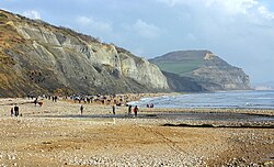
Designated in 2001, the Jurassic Coast encompasses nearly the entire length of the Dorset coast. This area is globally renowned for its geological structure and the abundance of fossils embedded within its cliffs. The region serves as a chronological map of Earth's history, with rock ages progressing from the Early Jurassic in the west to the Cretaceous in the east.
Visitors to this site can find a variety of spectacular geological formations. These include Lulworth Cove (a nearly circular cove), Stair Hole (an accessible geological fold), and Durdle Door (a natural sea arch). Other notable landmarks include the Old Harry Rocks sea stacks, the active landslip at Black Ven, and the towering heights of Golden Cap.
The Isle of Portland and Chesil Beach
Located roughly at the midpoint of the Dorset coast, the Isle of Portland is a tied island—an island connected to the mainland by a narrow strip of land. It measures approximately 4 miles long and 1.5 miles wide. The island is composed entirely of Portland limestone, a material that has been extensively quarried for centuries for use in building construction. The primary settlement on the peninsula is Fortuneswell.
The island is linked to the mainland by Chesil Beach, a 29-kilometre (18 mi) barrier beach stretching between West Bay and Portland. This beach is composed of shingle and pebbles that are naturally graded by size, with the smallest particles located in the west and the largest in the east. South-east of Abbotsbury, the beach separates the sea from The Fleet, a large body of brackish water (a mixture of freshwater and seawater).
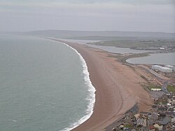
Between Fortuneswell and Weymouth lies Portland Harbour, which stands as one of the largest man-made harbours in the world.
The Isle of Purbeck and Poole Harbour
In the south-east of the county lies the Isle of Purbeck, a broad peninsula bounded by the English Channel and Poole Harbour. The peninsula is bisected from west to east by the chalk ridge of the Purbeck Hills. The northern region features heathlands where Purbeck Ball Clay has been excavated. The coastline here is highly varied, featuring sandy bays, limestone and chalk headlands, shales, and a small onshore oil well at Kimmeridge. The main settlement in this area is the resort town of Swanage.
To the north of Purbeck is Poole Harbour, one of the world's largest natural harbours, covering 14 square miles. Formed approximately 6,000 years ago after the last Ice Age, the harbour was created when rising sea levels flooded the valleys of the rivers Piddle and Frome. The harbour is characterized by an irregular shoreline with many small inlets, channels, and peninsulas. Its entrance, located between South Haven Point and the Sandbanks peninsula, is narrow, measuring less than 0.25 miles across. The harbour also contains several small islands, the most prominent being Brownsea Island.
Coastal Summary Table
| Feature | Type | Key Characteristic | Notable Location/Detail |
|---|---|---|---|
| Jurassic Coast | World Heritage Site | Geological variety and fossils | Lulworth Cove, Durdle Door |
| Isle of Portland | Tied Island | Portland limestone | Fortuneswell |
| Chesil Beach | Barrier Beach | Graded shingle and pebbles | The Fleet |
| Poole Harbour | Natural Harbour | 14 square miles; shallow | Brownsea Island |
| Isle of Purbeck | Peninsula | Chalk ridges and heathland | Swanage |
Frequently Asked Questions
What makes the Jurassic Coast unique?
The Jurassic Coast is unique due to its diverse geological structures and the abundance of fossils found in its cliffs, with rock ages ranging from the Early Jurassic to the Cretaceous periods.
How is the Isle of Portland connected to the mainland?
The Isle of Portland is connected to the mainland by Chesil Beach, a narrow strip of shingle and pebbles.
What is the significance of Chesil Beach's composition?
Chesil Beach is notable for its graded shingle, where the size of the pebbles increases from the smallest in the west to the largest in the east.
How was Poole Harbour formed?
Poole Harbour was formed about 6,000 years ago following the last Ice Age, when rising sea levels flooded the valleys of the rivers Frome and Piddle.
What is the highest point on the south coast of England?
The highest cliff on England's south coast is Golden Cap, located along the Dorset coastline.