Deal Island: A Remote Gem of the Kent Group
Located in the far reaches of the Southern Ocean, Deal Island serves as a fascinating intersection of natural beauty and human history. As part of the rugged Kent Group, this island is a sanctuary of biodiversity and a testament to the challenges of maritime navigation in one of the world's most isolated regions.
Environmental Protection and Geography
Deal Island is situated entirely within the Kent Group National Park, which was gazetted in 2002 and covers 2,374 hectares (5,870 acres). As Tasmania’s northernmost national park, it provides critical protection for the region's unique ecology. In 2004, the park's boundaries were expanded to include the marine waters surrounding the three primary islands of the Kent Group, adding 29,000 hectares (72,000 acres) of marine reserve to the protected area.
Beyond the national park, the island sits at the southern edge of the Beagle Commonwealth Marine Reserve. This massive reserve spans 292,800 hectares (724,000 acres) and encompasses the Kent Group Marine Reserve as well as the Hogan and Curtis Island groups.
Human Impact and Infrastructure
While largely remote, Deal Island has been significantly modified by human activity. Over time, the landscape has been altered through the clearing of native vegetation and the use of regular firing—a land management practice involving controlled burns—to support grazing livestock. Today, the island hosts several functional and historical structures, including a jetty, roads, a dam, two houses, a museum, and a closed airstrip.
The Southern Hemisphere's Highest Lighthouse
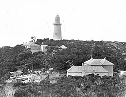
The most prominent feature of the island is the Deal Island Lighthouse. Standing 305 metres (1,001 ft) above sea level, it holds the distinction of being the highest lighthouse in the Southern Hemisphere. Built in 1848, the light was so powerful that it was occasionally visible from Wilson's Promontory, located 80 kilometres (50 mi) away.
Despite its impressive height, the tower faced operational challenges; its elevation often led to visibility issues during periods of low cloud cover. The lighthouse was eventually deactivated in 1992. Currently, the Tasmania Parks and Wildlife Service is responsible for the management and conservation of the structure.
A Somber Piece of History: The 1943 Aircraft Crash
Deal Island also bears the scars of World War II. On 26 April 1943, an RAAF Airspeed Oxford aircraft crashed into a cliff on the island, resulting in the deaths of all four crew members. According to eyewitness reports, the plane flew low over a shipwreck before failing to gain sufficient altitude to clear the cliffside.
The wreckage of the aircraft and the original graves of the crew remain on the island, situated approximately 15 metres (49 ft) apart at the base of the cliff. The crew members' bodies were later disinterred and moved to their final resting place in Springvale, Victoria.
Key Facts
- Highest Point: The lighthouse stands 305 metres (1,001 ft) above sea level.
- Conservation: Part of the Kent Group National Park and the Beagle Commonwealth Marine Reserve.
- Lighthouse History: Built in 1848 and deactivated in 1992.
- Marine Protection: Includes a 29,000-hectare marine reserve.
- WWII Site: Location of a 1943 RAAF Airspeed Oxford crash.
| Feature | Detail |
|---|---|
| National Park Area | 2,374 hectares (5,870 acres) |
| Marine Reserve Area | 29,000 hectares (72,000 acres) |
| Lighthouse Height | 305 metres (1,001 ft) |
| Lighthouse Active Years | 1848–1992 |
| Commonwealth Reserve | Beagle Commonwealth Marine Reserve (292,800 ha) |
Frequently Asked Questions
What makes the Deal Island Lighthouse unique?
It is the highest lighthouse in the Southern Hemisphere, reaching an elevation of 305 metres (1,001 ft) above sea level.
Who manages the lighthouse today?
The Tasmania Parks and Wildlife Service is in charge of the conservation and management of the lighthouse structure.
What happened to the RAAF crew who crashed in 1943?
All four crew members were killed in the crash. While they were initially buried on the island, their bodies were later moved to Springvale, Victoria.
Is Deal Island part of a protected area?
Yes, it is located within the Kent Group National Park and is also part of the larger Beagle Commonwealth Marine Reserve.
Why did the lighthouse have visibility problems?
Because of its extreme height, the light was often obscured by low cloud conditions, which hindered its effectiveness.