China Climate Data: Regional Temperature and Precipitation Analysis
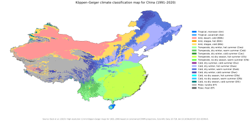
China's vast geography creates a diverse array of climatic conditions, ranging from the frigid plains of the northeast to the tropical coasts of the south and the high-altitude plateaus of the west. By analyzing meteorological normals—the average weather conditions over a specific period—we can identify the distinct patterns that define the country's regional environments.
The climate varies significantly based on latitude, elevation, and proximity to the ocean. For instance, coastal cities like Shanghai and Hong Kong experience higher humidity and more consistent temperatures, while inland cities like Ürümqi and Lanzhou face more extreme temperature swings.
Key Facts
- Extreme Heat: Turpan is one of the hottest regions, with maximum temperatures reaching 49.1°C (120.4°F).
- Extreme Cold: Harbin records some of the lowest temperatures, with extremes reaching -42.6°C (-44.7°F).
- High Precipitation: Hong Kong and Guangzhou lead in rainfall, with Hong Kong recording annual totals up to 2,431.2 mm.
- Altitude Impact: Lhasa, at an elevation of 3,649 m (11,972 ft), maintains cooler daily means despite its latitude.
- Seasonal Variance: Northern cities like Beijing and Shenyang show dramatic shifts between winter and summer daily means.
Regional Climate Breakdown
Northern China: Beijing, Tianjin, and Shenyang
The northern region is characterized by distinct seasonality. Beijing, situated at an elevation of 31 m, sees daily mean temperatures fluctuate from a low of 10.3°C in winter to 26.1°C in summer. Tianjin shows similar patterns, while Shenyang experiences harsher winters, with record lows reaching -33.1°C.
Northeast China: Harbin
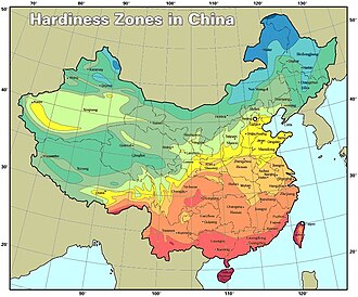
Harbin represents the extreme cold of the northeast. While its summer daily means can reach 23.1°C, its winter extremes are severe, with recorded lows of -42.6°C. Precipitation is moderate, totaling 537.9 mm annually.
Western and High-Altitude Regions: Lanzhou, Xining, Lhasa, and Ürümqi
Elevation plays a critical role in the west. Lhasa, the highest city in this dataset at 3,649 m, has a relatively stable daily mean temperature range (13.3°C to 23.9°C). In contrast, Ürümqi, at 935 m, experiences more volatility, with extremes ranging from -41.5°C to 42.1°C. Turpan, located in a depression at 39 m (and as low as -49 m at Dongkan Station), is exceptionally hot and dry.
Central and Eastern China: Wuhan, Shanghai, and Nanjing
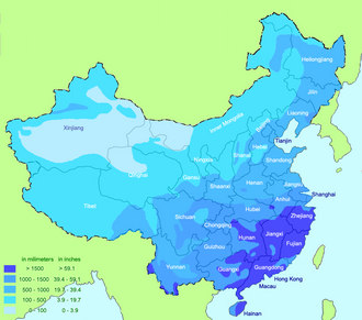
These regions are characterized by higher precipitation and humid conditions. Wuhan and Shanghai experience significant summer rainfall, with Shanghai recording 1,236 mm and Wuhan 1,310.2 mm annually. These cities maintain warmer winter daily means compared to the north, typically staying above 10°C.
Southern China: Guangzhou, Hong Kong, and Haikou
The south is dominated by tropical and subtropical climates. Hong Kong and Guangzhou record the highest precipitation levels in the dataset, with Hong Kong reaching 2,431.2 mm. Sanya, at a low elevation of 6 m, maintains a warm climate year-round with daily means rarely dropping significantly.
Comparative Climate Summary
The following table summarizes the climate normals for selected major cities to highlight the geographic disparity in temperature and rainfall.
| City | Elevation (m) | Max Temp Extreme (°C) | Min Temp Extreme (°C) | Annual Precipitation (mm) |
|---|---|---|---|---|
| Beijing | 31 | 41.9 | -27.4 | 528 |
| Harbin | N/A | 39.2 | -42.6 | 537.9 |
| Lhasa | 3,649 | 30.8 | -11.2 | 472.9 |
| Turpan | 39 | 49.1 | -26.1 | N/A |
| Shanghai | N/A | 40.0 | -10.1 | 1,236 |
| Hong Kong | N/A | N/A | N/A | 2,431.2 |
Frequently Asked Questions
Which city in the dataset has the highest recorded temperature?
Turpan has the highest recorded temperature, reaching a maximum of 49.1°C (120.4°F).
Which city experiences the most severe cold?
Harbin experiences the most severe cold, with a record minimum temperature of -42.6°C (-44.7°F).
How does elevation affect the temperature in Lhasa?
Despite its southern latitude, Lhasa's high elevation of 3,649 m keeps its daily mean temperatures relatively cool, ranging from 13.3°C to 23.9°C.
Which region receives the most annual rainfall?
The southern coastal regions receive the most rainfall, with Hong Kong recording the highest annual precipitation at 2,431.2 mm.
What is the difference in precipitation between Beijing and Shanghai?
Shanghai receives significantly more rainfall (1,236 mm) compared to Beijing (528 mm), reflecting the difference between coastal and inland northern climates.