Caral–Supe Civilization: The Oldest Known Society in the Americas
Long before the rise of the Inca or the Maya, a complex society flourished along the north-central coast of Peru. Known as the Caral–Supe civilization (also referred to as Caral or Norte Chico), this society is now recognized as the oldest known civilization in the New World. Emerging between the 4th and 2nd millennia BCE, it represents one of only six places globally where civilization independently originated.
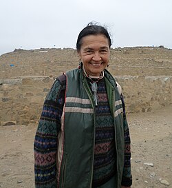
For decades, historians focused on the Andean highlands to find the roots of South American complexity. However, the discovery and documentation of Caral–Supe shifted this perspective toward the Peruvian littoral—the coastal regions. Through the work of archaeologists like Ruth Shady, the world has come to understand a society that built massive pyramids and organized urban centers thousands of years before previously thought possible.
Key Facts
- Time Period: Flourished from approximately 3500 BCE to 1800 BCE.
- Location: North-central coastal Peru, spanning the Huaura, Supe, Pativilca, and Fortaleza valleys.
- Status: Recognized as the oldest civilization in the Americas.
- Key Site: Caral, featuring monumental platform mounds and sunken plazas.
- Defining Feature: Part of the "Cotton Preceramic" stage, characterized by a lack of ceramics.
Geography and Early Settlement
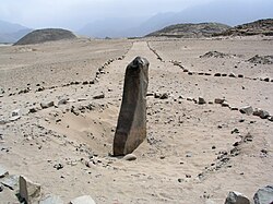
The Caral–Supe civilization was concentrated in a coastal plain roughly 150 to 200 km north of modern-day Lima. The society was distributed across four primary valleys, with the highest density of population centers found in the Supe, Pativilca, and Fortaleza valleys.
Evidence of human presence in the region dates back as far as 9210 BCE, though these were limited settlements. Large-scale communal construction and permanent urban settlement became clearly apparent around 3200 BCE, with the first city generally dated to 3500 BCE at Huaricanga in the Fortaleza area.
Architecture and Urban Planning
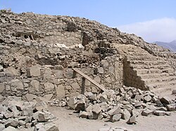
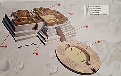
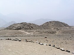
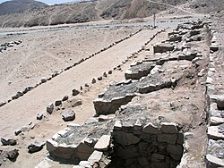
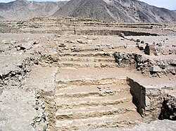
The scale of construction in the Norte Chico region is formidable. Archaeologists have identified up to thirty major population centers, with sites ranging from 10 to 100 hectares. The architecture is defined by platform mounds—large, rectangular, terraced pyramids built with stone fill.
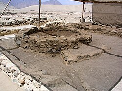
At the site of Caral, the central zone covers over 65 hectares and includes six platform mounds and two sunken circular plazas. The largest structure, the Piramide Mayor, measures 160 by 150 meters and reaches a height of 18 meters.
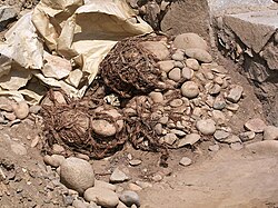
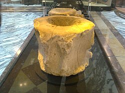
To support these massive projects, the civilization utilized shicra bags—woven bags filled with stones used as foundation fill to provide stability to the pyramids.
Ceremonial and Social Spaces
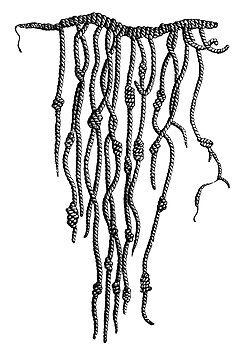
Beyond the pyramids, the sites featured specialized areas such as the Altar of the Holy Fire atop the Templo Mayor and various residential structures. The presence of quipu (knotted strings) suggests the possible use of a "proto-writing" system for record-keeping.
Diet and Economic Foundation
The economic basis of Caral–Supe was a sophisticated blend of maritime resources and inland agriculture. For years, the "Maritime Foundations of Andean Civilization" hypothesis suggested that seafood provided the bulk of their nutrition. However, a 2022 forensic study of human remains revealed that plant-based foods actually dominated the diet, making up over 70% of nutrition at Caral.
While seafood was vital—particularly at coastal sites like Aspero—the civilization relied heavily on maize. Recent data from pollen records and coprolites (fossilized feces) confirm that maize was widely grown and processed between 3000 and 1800 BCE.
| Feature | Details |
|---|---|
| Primary Period | c. 3500 BCE – 1800 BCE |
| Key Crops | Maize and Cotton |
| Architectural Style | Terraced platform mounds and sunken plazas |
| Dietary Base | Predominantly plant-based (55%–70%+) with seafood supplement |
| Technological Stage | Cotton Preceramic (no pottery) |
Climate Crisis and Adaptation
The decline of the Caral–Supe civilization around 1800 BCE is linked to environmental shifts. Research led by Ruth Shady suggests that a prolonged drought around 2200 BCE, part of a global 4.2-kiloyear climate event, forced the population to relocate.
Rather than a total collapse, populations moved to sites like Vichama on the coast and Peñico inland. Temple friezes at Vichama provide a visual record of this era, depicting scenes of famine and death followed by images of renewal, such as pregnant women and large fish, symbolizing the hope for returning rainfall.
Frequently Asked Questions
Why is it called the "Cotton Preceramic" stage?
The term, coined by Frédéric Engel in 1957, describes ancient coastal sites that cultivated cotton for nets and textiles but had not yet developed the technology to create ceramic pottery.
Did the Caral–Supe people have a writing system?
While they did not have a written alphabet, the discovery of quipu (knotted strings) suggests they used a complex system of knots for accounting or communication, which some researchers call a "proto-writing" system.
Was the civilization based entirely on fishing?
No. While maritime resources were significant, especially for coastal settlements, forensic evidence shows that plant-based foods, including maize, made up the majority of their diet.
How did the civilization end?
The society did not suddenly vanish but adapted to a severe drought around 2200 BCE. Populations relocated and rebuilt their settlements in different areas, preserving their architectural and ceremonial traditions.
What was the purpose of the platform mounds?
These large, terraced pyramids served as the centers of urban and ceremonial life, likely used for religious rituals and as symbols of political or ideological power.