Capote Falls: Texas' Highest Waterfall and a Rare Botanical Oasis
Hidden within the rugged Sierra Vieja mountains of northwestern Presidio County, Texas, lies a remarkable natural wonder: Capote Falls. As the highest waterfall in the state, reaching heights of up to 175 feet (53 m), this cascading landmark serves as a vital, moist oasis amidst an otherwise arid landscape. While the surrounding terrain is characterized by sparse shrubbery, the falls create a unique microclimate that supports life found nowhere else in the region.
Key Facts
- Height: Up to 175 feet (53 m), making it the tallest waterfall in Texas.
- Location: Sierra Vieja mountains, Presidio County, Texas (on the privately owned Brite Ranch).
- Unique Flora: The only wild habitat for Aquilegia hinckleyana (Hinckley's columbine).
- Geology: Formed by Capote Creek flowing off a volcanic rim composed of rhyolite and tuff.
- Access: Restricted to property owners; helicopter flyovers are an option for viewing.
Geology and Landscape
Capote Falls is formed by Capote Creek as it descends from the volcanic rim of the Sierra Vieja mountains. The creek originates from Capote Springs, which was recorded in July 1976 as flowing at a rate of 2 gallons per second. The falls are framed by box canyons on three sides, creating a dramatic and enclosed setting.
The local geology is primarily composed of rhyolite (a volcanic rock) and tuff (consolidated volcanic ash), interspersed with areas of sand, clay loams, and stony patches. The name "Capote" may refer to a cape-like slope of travertine—a form of terrestrial limestone deposited by mineral springs—located behind the lower cascade. Alternatively, the name may be derived from the nearby Capote Peak.
| Feature | Details |
|---|---|
| Maximum Height | 175 feet (53 m) |
| Primary Rock Types | Rhyolite and Tuff |
| Water Source | Capote Springs |
| County | Presidio County, Texas |
A Fragile Ecosystem
Despite its impressive scale, the environment at Capote Falls is delicate. Since 1964, significant erosion has altered the landscape, causing the once-deep basin at the base of the falls to become shallow. This erosion has even begun to expose the roots of mesquite trees along the canyon edges.
Unique Flora
The moist banks at the base of the falls support a diverse array of plant life that contrasts sharply with the surrounding desert. In 1974, reports indicated the presence of nine rare, endangered, or endemic plant species. Most notable is Aquilegia hinckleyana, commonly known as Hinckley's columbine. This species is endemic to this specific area, meaning it is found naturally only in this small location.
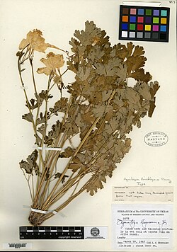
The columbine was first collected by L. C. Hinckley in 1943 and formally described by botanist Philip A. Munz in 1946. Alongside these rare flowers, the area hosts maidenhair ferns, foxtail, various other ferns, and cottonwoods. The columbine also plays a critical role in the local food web, serving as a host for the larvae of the columbine duskywing butterfly (Erynnis lucilius).
Diverse Fauna
The canyon surrounding the falls provides a sanctuary for a wide variety of wildlife. Ornithological surveys have identified 76 species of birds in the area, including canyon wrens and the black vulture, which is relatively rare in much of Texas. The mammalian population is equally diverse, with 29 species recorded, including:
- Mountain lions
- Bobcats
- Mule deer
- Badgers
- Porcupines
- A rare colony of mastiff bats
Additionally, the area is home to a unique species of all-female whiptail lizards.
History and Access
While the falls have been near major expedition routes for centuries, European records of the site are sparse. The explorer Antonio de Espejo is the only recorded European to pass the falls prior to the 19th century, during his 1583 expedition to the Rio Grande. The land was eventually acquired for cattle ranching in 1885 by Lucas Charles Brite.
Today, Capote Falls is located on the privately owned Brite Ranch. Because it is private property, access is restricted to those with explicit permission from the owners. For those wishing to witness the falls without trespassing, helicopter flyovers are a recognized option for viewing the site from above.
Frequently Asked Questions
Is Capote Falls open to the public?
No, Capote Falls is located on the privately owned Brite Ranch. Access is restricted to individuals who have obtained permission from the property owners.
What makes the flora at Capote Falls unique?
The falls create a moist microclimate that allows species like Hinckley's columbine (Aquilegia hinckleyana) to survive. This plant is endemic to the area, meaning it is found in the wild only at this specific location.
How tall is the highest waterfall in Texas?
Capote Falls is considered the highest waterfall in Texas, with recorded heights reaching up to 175 feet (53 m).
Has the waterfall changed over time?
Yes, the site has experienced significant erosion since 1964, which has caused the basin at the base of the falls to become much shallower than it was previously.
What kind of animals live near the falls?
The area supports a wide range of wildlife, including 76 bird species, 29 mammal species (such as mountain lions and mastiff bats), and all-female whiptail lizards.