Canada: A Comprehensive Overview of Geography, History, and Governance
Spanning from the Atlantic to the Pacific and northward to the Arctic, Canada is the world's second-largest country by total area. Known for its vast landscapes and diverse population, the nation operates as a federal parliamentary constitutional monarchy. This complex and rich identity is shaped by its indigenous roots, European colonial history, and a modern commitment to multiculturalism.
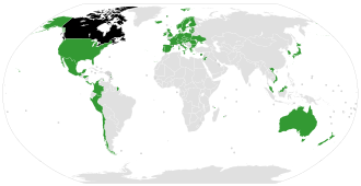
Key Facts
![A map of Canada showing the percent of self-reported indigenous identity (First Nations, Inuit, Métis) by census division, according to the 2021 Canadian census[23]](/images/3a/48/3a48ba156154af03e6f3cdb543b6818a9dce45dfbf6e9a3b8e948644f68d93d3.webp)
- Capital City: Ottawa
- Largest City: Toronto
- Official Languages: English and French
- Total Area: 9,984,670 km²
- Government Type: Federal parliamentary constitutional monarchy
- National Motto: A mari usque ad mare ("From Sea to Sea")
Geography and Climate
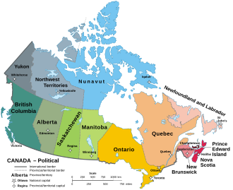
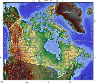
Canada's physical landscape is incredibly varied, ranging from rugged mountains to vast plains and coastal regions. The country's total area includes a significant water component, making up approximately 11.76% of its territory. The topography is diverse, featuring various elevations that can be categorized into distinct physiographic regions.
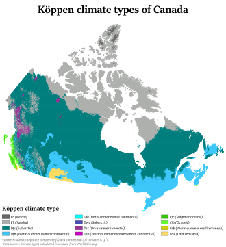
The climate across the nation is equally varied. Using the Köppen climate classification—a system used to categorize climates based on temperature and precipitation—Canada exhibits a wide range of environmental conditions, from arctic climates to temperate zones.
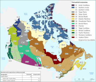
Biodiversity is supported by a variety of terrestrial ecozones and ecoprovinces, which are subdivisions of larger ecological regions. These zones help scientists understand the distribution of plant and animal life across the Canadian landscape.
Historical Evolution
![Diplomatic missions of Canada[202] Countries that host a Canadian Embassy or High Commission Interests section and other representations Countries that do not host Canadian diplomatic missions Canada](/images/81/04/81046430c69535353f6e13f8d1c1f6949376db977900bffab058e384e6426d31.png)
The history of Canada is a narrative of transformation, beginning with the long-standing presence of Indigenous peoples. Following European contact, the region saw significant colonial competition, notably between the British and the French.
![Map of territorial claims in North America by 1750. Possessions of British America (pink), New France (blue), and New Spain (orange); California, Pacific Northwest, and Great Basin not indicated.[38]](/images/91/db/91db47bf97223c25a2b1b95e2a59af70910d38b4cc106498375dfb994ee2eaa2.webp)
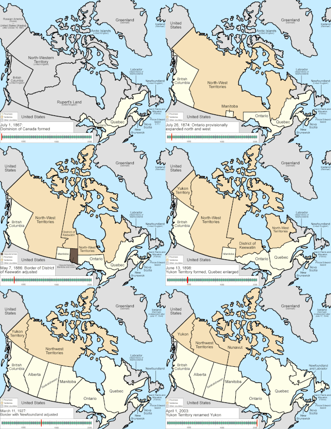
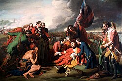
Key historical moments include the Battle of the Plains of Abraham and the various conflicts that shaped the borders of what would become British North America. The path to modern statehood was marked by several milestones:
- Confederation (July 1, 1867): The founding of the Canadian dominion.
- Balfour Declaration (1926) and Statute of Westminster (1931): Steps toward legislative independence from the United Kingdom.
- Patriation (April 17, 1982): The process of bringing the Constitution under Canadian control.
Government and Law

Canada's political structure is defined by its status as a constitutional monarchy. The Monarch (currently Charles III) serves as the formal head of state, represented in Canada by the Governor General. The actual administration of the country is handled by the Prime Minister and the Parliament.
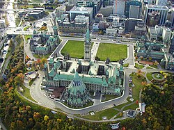
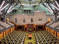
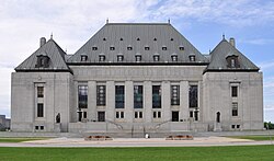
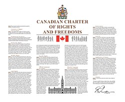
The Parliament consists of two houses: the Senate (the upper house) and the House of Commons (the lower house). This legislative body works alongside the judicial system, headed by the Supreme Court of Canada, to uphold the rule of law and the rights of citizens as outlined in the Canadian Charter of Rights and Freedoms.
![Freedom of religion sculpture by Marlene Hilton Moore at the McMurtry Gardens of Justice in Toronto[318]](/images/0c/74/0c7423013b6c75d32892421f71b20b795bc7fb8be05bcf5b05a0d961df7285cf.jpg)
Demographics and Society
Canada is a highly diverse nation. As of the 2021 census, the population was approximately 36.99 million, with estimates for late 2025 reaching over 41 million. The population is distributed unevenly, with high concentrations in metropolitan areas and the Quebec City–Windsor Corridor.
![Canada population density map (2014)Top left: The Quebec City–Windsor Corridor is the most densely inhabited and heavily industrialized region.[276]](/images/73/38/7338ff5c4211590614f1584487e220ea0cd89896b0ed8e4e3b15d1973bb2f6e3.gif)
The nation's social fabric is characterized by its official bilingualism (English and French) and a strong emphasis on multiculturalism. The 2021 census highlights a wide array of ethnic and cultural origins among Canadians, contributing to a vibrant social landscape.
![The top 168 ethnic or cultural origins self-reported by Canadians in the 2021 census[294]](/images/3f/f2/3ff23175b618361d8de50ab237445d560ce9240704c36f98e9f49685ebb5b29a.png)
![Percentage of the population who could conduct a conversation in English and French in 2021[305]](/images/14/4b/144b1428689ca56d831b07e64ce9282c5aae20064e251e7101b146f542354bf4.png)
![Monument to Multiculturalism by Francesco Pirelli, in Toronto[359]](/images/50/10/50106072146bbd612f0b4a7c1ec3cd9aa21a28f4fe981d3f9773e70a2e1ef1fe.jpg)
Major Metropolitan Areas
| Rank | Name | Province | Population |
|---|---|---|---|
| 1 | Toronto | Ontario | 6,202,225 |
| 2 | Montreal | Quebec | 4,291,732 |
| 3 | Vancouver | British Columbia | 2,642,825 |
| 4 | Ottawa–Gatineau | Ontario–Quebec | 1,488,307 |
| 5 | Calgary | Alberta | 1,481,806 |
| 6 | Edmonton | Alberta | 1,418,118 |
| 7 | Quebec City | Quebec | 839,311 |
| 8 | Winnipeg | Manitoba | 834,678 |
| 9 | Hamilton | Ontario | 785,184 |
| 10 | Waterloo Region | Ontario | 575,847 |
Economy and Technology
![Canada by province and territory, showing the percentage of the population aged 25 to 64 who had a bachelor's degree or higher, and the percentage point change from 2016 to 2021[346]](/images/36/0a/360a3d2333e8e302230b480e81882a816b689370230994af762b7abc9667549f.png)
Canada possesses a robust economy, with a significant Gross Domestic Product (GDP). The nation is a global player in various sectors, including finance, natural resources, and technology. The Toronto financial district, for instance, stands as one of the largest financial centers in North America.
![The Toronto financial district is the second-largest financial centre in North America, the seventh-largest globally in employment and the heart of Canada's finance industry.[226]](/images/b3/92/b392f585c164073d8fa4abf3fe6c3de18db0b16db487ffdfe3b0ecca0a30d893.jpg)
Technological innovation is also a hallmark of the country, evidenced by contributions to space exploration, such as the development of the Canadarm robotic systems used in space missions.
![The Canadian-built Space Shuttle robotic arm (left), referred to as Canadarm, transferred the P5 truss segment over to the Canadian-built space station robotic arm, referred to as Canadarm2.[263]](/images/cd/14/cd14f2157c68a70f35a4b2cc282403e4ce7bb2d0aebe7f8bb16f6223ae7a2449.jpg)
Frequently Asked Questions
![Author Margaret Atwood has suggested that during the 1970s Canadian literature was still looking for a national identity.[382]](/images/9d/17/9d17fe3ac3600b29d719da5e3bc1efdc9451a20ffba413672817de076fb4723e.jpg)
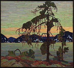
![Original publication of "O Canada" in English, 1908 (French, 1880)[402]](/images/95/1c/951cf8fc834a213dbb6f3db73630d1c7ce8c41b09d88eed7daa9bbd1ab3d02c9.jpg)
![Our Game sculpture by Edie Parker outside the Hockey Hall of Fame in Toronto[423]](/images/2d/76/2d768ac07f2512f1bc96a3762c8df7730835158b7162608c5143daec13443a55.jpg)
What are the official languages of Canada?
Canada has two official languages: English and French.
How is the Canadian government structured?
Canada is a federal parliamentary constitutional monarchy, featuring a Parliament consisting of the Senate and the House of Commons, with a Monarch as the head of state.
What is the capital of Canada?
The capital city of Canada is Ottawa.
What is the largest city in Canada?
Toronto is the largest city in Canada.
When did Canada become a country?
Canada was formed through Confederation on July 1, 1867.