Beqaa Valley: Lebanon's Fertile Heartland of History and Agriculture
The Beqaa Valley (Arabic: وادي البقاع) is the agricultural powerhouse of eastern Lebanon. Stretching across a vast landscape of fertile soil, this region is essential to the country's food security and industrial growth. Located approximately 30 km east of Beirut, the valley is cradled between the Mount Lebanon range to the west and the Anti-Lebanon Mountains to the east.
Geologically, the Beqaa is a northern continuation of the Jordan Rift Valley, making it a vital segment of the Great Rift Valley that extends from Syria down to southeast Africa. Spanning 120 kilometers in length and averaging 16 kilometers in width, the region enjoys a Mediterranean climate characterized by warm, dry summers and wet, often snowy winters.
Key Facts
- Dimensions: 120 km long and 16 km wide.
- Agricultural Importance: Comprises 40% of Lebanon's total arable land.
- Geography: Situated between Mount Lebanon and the Anti-Lebanon Mountains.
- Major Cities: Zahle (administrative capital) and Baalbek.
- Key Industries: Viticulture (wine), grain production, and livestock.
A Journey Through Time: From Prehistory to Rome
Ancient Beginnings
Human habitation in the region is ancient. In Baalbek, evidence suggests continuous settlement for 8,000 to 9,000 years. Archaeological sites like Ard Tlaili date back to 5780–5710 BC, featuring some of the southernmost pottery of the Halaf Culture (an early Neolithic culture). Similarly, the village of Labweh has been settled since the Neolithic period.
The Bronze and Iron Ages
During the Middle Bronze IIA, the valley—then known as Amqu—served as a critical highway between the regional power of Qatna and its vassal Hazor. The area was integrated into the Amorite Kingdoms of Amurru and Qatna. By the early Iron Age, the population shifted toward Phoenician and Aramaic speakers. Scholars believe the biblical kingdom of Aram-Zobah was located here, later serving as a residence for an Assyrian governor in the 8th and 7th centuries BC.
Hellenistic and Roman Influence
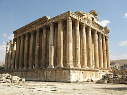
Before the rise of Rome, the valley was inhabited by the Itureans, a people described as Arab peasants. They eventually formed the Kingdom of Chalcis, expanding their reach toward Damascus and the coast. Under the Roman Empire, the Beqaa became a vital agricultural hub for the Levant. The Romans left a lasting legacy of monumental architecture, including the famous temples of Baalbek. Additionally, Queen Zenobia of Palmyra constructed the Canalizations of Zenobia to link the valley with her city.
Geography and Demographics
Major Towns and Districts
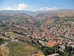
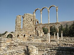
Zahle is the largest city and the administrative capital of the Beqaa Governorate, known for its diverse Christian population. To the east lies Anjar, home to a predominantly Armenian Lebanese population and renowned for its 8th-century Umayyad ruins.
The northern districts of Baalbek and Hermel are primarily inhabited by Lebanese Shiites, while the western and southern districts feature a mixed population of Muslims, Christians, and Druze. The town of Joub Janine serves as the governmental center for Western Beqaa.
Climate and Natural Resources
The valley experiences a rain shadow effect caused by Mount Lebanon, which blocks moisture from the sea. This results in lower rainfall in the north (230 mm annually) compared to the central valley (750 mm). Despite this, the region is fed by two major rivers: the Orontes (Asi), which flows north into Syria and Turkey, and the Litani, which flows south and west toward the Mediterranean.
Economic Pillars: Wine and Agriculture
The Wine Industry
With an average altitude of 1,000 meters, the Beqaa Valley is ideal for viticulture. The combination of winter rains and summer sunshine allows grapes to ripen perfectly. Lebanon's wine tradition spans 6,000 years, and today, over a dozen wineries—including Château Ksara and Château Musar—produce more than six million bottles annually.
Crop Diversity
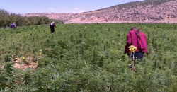
While the north is used primarily for grazing by pastoral nomads, the south supports fertile crops of wheat, maize, cotton, and vegetables. However, the region has also a history of illicit crop cultivation, specifically cannabis (hashish) and opium poppies.
The Challenge of Illicit Drugs
Cannabis cultivation became a major income source during the Lebanese Civil War, often controlled by militias and foreign interests. While a massive U.S.-led crackdown in the early 1990s significantly reduced production, cultivation has seen some resurgence in the north due to political instability and a lack of economic alternatives for farmers.
Regional Summary
| Feature | Details |
|---|---|
| Length/Width | 120 km / 16 km |
| Primary Rivers | Orontes and Litani |
| Key Crops | Grapes, Wheat, Maize, Cotton |
| Major Landmarks | Baalbek Temples, Anjar Ruins, Lake Qaraoun |
| Administrative Capital | Zahle |
Frequently Asked Questions
What is the Beqaa Valley known for?
The Beqaa Valley is primarily known as Lebanon's most important farming region, producing a significant portion of the country's grain and world-renowned wines, as well as hosting the ancient Roman ruins of Baalbek.
Why is the climate different in the north versus the center of the valley?
The northern section receives less rainfall because Mount Lebanon creates a rain shadow, blocking precipitation coming from the Mediterranean Sea.
Which ancient civilizations inhabited the Beqaa Valley?
The region has been inhabited by the Halaf Culture, Amorites, Aramaeans, Phoenicians, Itureans, and was later a key agricultural province of the Roman Empire.
What are the most significant landmarks in the region?
Key landmarks include the Roman temples of Baalbek, the Umayyad ruins of Anjar, Lake Qaraoun (the largest artificial reservoir in Lebanon), and the various historic wineries like Château Ksara.
How does the Beqaa Valley contribute to Lebanon's economy?
It provides 40% of Lebanon's arable land, supporting the national agricultural industry and a thriving wine export market.