Understanding the Antarctic Convergence: The Ocean's Great Natural Boundary
In the vast expanse of the Southern Ocean, there exists a powerful, invisible boundary that dictates the movement of water, the flow of currents, and the survival of marine life. This phenomenon is known as the Antarctic Convergence, also referred to as the Antarctic Polar Front. Unlike the political borders drawn on maps by humans, this is a dynamic, biological, and hydrological frontier where two vastly different worlds collide.
What is the Antarctic Convergence?
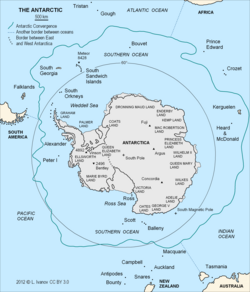
The Antarctic Convergence is a marine belt that encircles the Antarctic continent. It marks the meeting point between the cold, northward-flowing Antarctic waters and the significantly warmer waters of the sub-Antarctic. This collision creates a distinct separation between the clockwise Antarctic Circumpolar Current—a massive system of ocean currents—and the surrounding oceans.
This boundary is a natural phenomenon, much like the Arctic tree line. While the Arctic lacks a similar oceanic boundary due to the large landmasses connected to the northern polar region, the Antarctic is surrounded by open ocean, allowing this convergence to form a continuous loop. This line does more than just separate water temperatures; it divides two distinct hydrological regions, creating unique climates and habitats for marine organisms.
A Hub of Marine Productivity
The interaction between these water masses is not merely a collision; it is a process of mixing. As the cold Antarctic waters move north, they predominantly sink beneath the warmer sub-Antarctic waters. This movement triggers upwelling—a process where deep, nutrient-rich water rises toward the surface. These zones of mixing and upwelling create an environment of extremely high marine productivity, providing a vital food source for species such as Antarctic krill.
Key Facts
- Nature of Boundary: A natural hydrological and biological frontier, not a political one.
- Temperature Shift: Crossing the line results in an average temperature drop of 2.8 °C (5.0 °F).
- Width: The zone is approximately 37 to 55 km (20 to 30 nmi) wide.
- Primary Driver: The meeting of cold Antarctic waters and warmer sub-Antarctic waters.
- Ecological Importance: High productivity due to upwelling, supporting Antarctic krill.
History and Discovery
Humanity's encounter with this boundary dates back centuries. The Antarctic Convergence was first crossed by Anthony de la Roché in 1675 and later by Edmond Halley in 1700. However, it was not until the scientific expeditions of the early 20th century—specifically the British Discovery Investigations and the German Meteor Expedition between 1925 and 1927—that the convergence was formally described and scientifically understood.
Location and Geographic Characteristics
The Antarctic Convergence is a mobile zone that spans the Atlantic, Pacific, and Indian oceans. It generally exists between the 48th and 61st parallels of south latitude. Because it is influenced by seasonal changes, its latitude varies, though it typically does not stray more than half a degree of latitude from its mean position.
One of the most reliable ways to identify the convergence is through a sudden drop in seawater temperature. As one moves from north to south across the line, temperatures typically plummet from an average of 5.6 °C (42.1 °F) to below 2 °C (36 °F).
Legal Definitions and Boundaries
Because the convergence is a moving target, international agreements have established specific coordinates to define the zone for conservation purposes. Under the Convention on the Conservation of Antarctic Marine Living Resources 1980, the boundary is defined by a series of specific longitudinal and latitudinal points to ensure the protection of the region's marine life.
| Feature | Description |
|---|---|
| Primary Function | Separates Antarctic and sub-Antarctic waters |
| Typical Width | 37 to 55 km (20 to 30 nmi) |
| Average Temp Drop | 2.8 °C (5.0 °F) |
| Oceanic Coverage | Atlantic, Pacific, and Indian Oceans |
| Key Biological Driver | Upwelling and nutrient mixing |
Frequently Asked Questions
How does the Antarctic Convergence differ from the Arctic?
The Arctic does not have a similar oceanic boundary because it is characterized by large bodies of land that are contiguous with the northern polar region. In contrast, the Antarctic is surrounded by ocean, allowing the convergence to form a continuous marine belt.
What happens to the water temperature at the convergence?
There is a sudden and significant drop in temperature. On average, seawater temperatures fall by 2.8 °C (5.0 °F) when moving from north to south, dropping from roughly 5.6 °C (42.1 °F) to below 2 °C (36 °F).
Why is this area so important for marine life?
The convergence creates zones of mixing and upwelling, where cold Antarctic waters sink beneath warmer waters. This process brings nutrients to the surface, creating a highly productive environment that supports massive populations of Antarctic krill.
Is the boundary of the convergence permanent?
No, it is a mobile zone. Its latitude varies seasonally and changes depending on the longitude, though it generally stays within half a degree of its mean position.
Who first described the Antarctic Convergence?
While explorers like Anthony de la Roché and Edmond Halley crossed the area in the 17th and 18th centuries, the convergence was first scientifically described by the British Discovery Investigations and the German Meteor Expedition between 1925 and 1927.