Annette Island Climate and Weather Patterns
Annette Island is characterized by a Marine west coast climate (classified as Köppen Cfb), a weather pattern defined by its maritime influence. This results in a year-round cycle of windy and wet conditions, featuring mild summers and cool winters. Because of its southerly position and proximity to the ocean, the island maintains a temperate environment that stands out within the state of Alaska.
The region straddles the border between USDA Plant Hardiness Zones 7 and 8, indicating a climate capable of supporting a variety of plant life that would typically struggle in harsher northern latitudes.
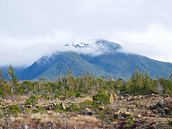
Key Facts
- Annual Mean Temperature: 47.7 °F (8.7 °C).
- Annual Precipitation: Averages more than 103 inches (2.62 m).
- Temperature Extremes: Ranging from −4 °F (−20 °C) to 93 °F (34 °C).
- Seasonal Snowfall: Total average of 33.5 inches (85 cm).
- State Records: The Annette Island Airport holds Alaska's monthly record highs for January, April, and November.
Temperature Trends and Extremes
The Annette Island Airport is recognized as one of the warmest locations in Alaska. The annual mean temperature sits at 47.7 °F (8.7 °C), though daily fluctuations occur throughout the year. Summer brings a moderate warmth, with an average of 17 days reaching highs of 70 °F (21 °C) or more.
Winter temperatures remain relatively mild for the region, though extreme cold does occur. The lowest recorded temperature was −4 °F (−20 °C) on January 30, 1947. Conversely, the highest temperature ever recorded on the island was 93 °F (34 °C) on June 19, 2004. Notably, temperatures have dropped below 0 °F (−18 °C) only a handful of times.
State Temperature Records
The airport is a site of significant meteorological records for Alaska, holding the monthly record high temperatures for three different months:
- January: 66 °F (19 °C) on January 14, 2017.
- April: 82 °F (28 °C) on April 29, 1976.
- November: 67 °F (19 °C) on November 1, 1970.
Precipitation and Snowfall
Water is a dominant feature of the Annette Island climate. With annual precipitation averaging over 103 inches (2.62 m), the island is consistently wet. The wettest months are typically October and November, while June and July provide the driest window of the year. Even during the summer, rain falls on approximately half of all days.
Snowfall is primarily a winter phenomenon, occurring mostly from November through March, with some accumulation continuing into April. The seasonal total averages 33.5 inches (85 cm). While snowfall in May and October is rare, occasional warm spells in these months can push temperatures up to 50 °F (10 °C) for several days.
Climate Data Summary
| Metric | Winter (Jan) | Spring (Apr) | Summer (Jul) | Autumn (Oct) | Annual Average |
|---|---|---|---|---|---|
| Mean Daily Max (°F) | 42.9 | 51.8 | 65.9 | 53.6 | 53.6 |
| Daily Mean (°F) | 37.7 | 45.4 | 59.7 | 47.9 | 47.7 |
| Mean Daily Min (°F) | 32.5 | 38.9 | 53.5 | 42.3 | 41.8 |
| Precipitation (Inches) | 10.43 | 7.18 | 5.17 | 12.87 | 103.51 |
| Precipitation Days | 21.9 | 19.1 | 15.4 | 22.5 | 231.4 |
Frequently Asked Questions
What type of climate does Annette Island have?
Annette Island has a Marine west coast climate (Köppen Cfb), which is characterized by mild summers, cool winters, and consistent wind and rain throughout the year.
Is Annette Island one of the warmest places in Alaska?
Yes, due to its maritime location and southerly position, the Annette Island Airport is one of the warmest locations in the state, with an annual mean temperature of 47.7 °F (8.7 °C).
When is the wettest time of year on the island?
The wettest months are October and November, contributing to an annual precipitation average of over 103 inches.
How much snow does Annette Island typically receive?
The island receives a seasonal total snowfall average of 33.5 inches (85 cm), with the majority of this occurring between November and March.
What are the record temperature extremes for the area?
The record high is 93 °F (34 °C), set on June 19, 2004, and the record low is −4 °F (−20 °C), recorded on January 30, 1947.