Western Park: A History of Auckland's Oldest Municipal Green Space
Nestled in the heart of the city, Western Park stands as one of Auckland's most distinguished open spaces. While the Auckland Domain is well-known, Western Park holds the distinction of being the city's oldest municipal park, as the Domain was established by the Central Government rather than the local council.
The park's origins date back to 1871, when a coffin-shaped wedge of land was set aside. This area stretched from Ponsonby Road down to Beresford Street, though it initially had only a very narrow frontage on Ponsonby Road. The land centered around a stream known in pre-European times by the local Māori as Tuna-Mau, meaning 'the trapping of eels.' This stream was one of several that once flowed into Freeman Bay, an area that has since been reclaimed to become Victoria Park.
The Vision and Design of the "City Park"
In 1873, the city council sought a professional design for the space, offering a prize of ten guineas (a significant sum at the time) to the winner. After reviewing 11 different concepts, the council selected the 'Lily of the Valley' design submitted by Hammond and Blackmore. This new "City Park," later renamed Western Park, was completed at a cost of £200.
By 1874, the City Parks Committee recorded the planting of over 1,100 deciduous and coniferous trees of the highest quality. This extensive planting transformed the park into an arboretum—a botanical garden devoted to the cultivation of diverse tree specimens—which was a relatively new concept for the era. Many of these specimen trees were donated by prominent citizens, including Sir Maurice O'Rorke (Speaker of the House) and Sir George Grey.
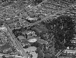
The park was officially vested with the city council in 1875 and opened to the public on November 17, 1879. The Auckland Star noted at the time that the city was following the example of the "civilised world" by establishing such a space.
Layout and Evolution of the Grounds
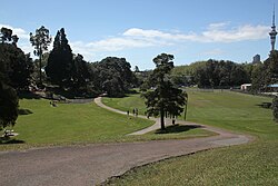
The park was designed to follow the natural topography of the land. Winding paths lead visitors down the hill from Ponsonby Road to a flat area at the base. Historically, the upper section of the park offered sweeping views of the city and the Waitematā Harbour, while the lower section was reserved for activities.
Over time, the park's boundaries and features have shifted:
- Eastern Boundary: Since 1909, the grounds of Auckland Girls' Grammar School have bounded the eastern edge, creating a seamless merge of greenery.
- Western Boundary: Late 19th-century private residences line the western edge, though they are largely hidden by mature trees.
- 1970s Expansion: The park grew when two portions of land on Ponsonby Road were incorporated. This required the demolition of a wooden house on Hopetoun Street and a block of shops known as the "Western Stores" on the corner of Hepburn Street.
- Modern Additions: A decommissioned public road at the bottom of the park was converted into asphalt tennis courts. In the 1980s, further land on Hopetoun Street was added, which was later re-landscaped in the early 2000s to include a harbour viewing platform.
Modern Features and Artistic Contributions
While the original 19th-century trees have grown so large that they now obscure the harbour views from Ponsonby Road, the park continues to blend history with modern art. A Band Rotunda, built around 1910 near the Ponsonby Road entrance, served as a centerpiece for decades before its demolition in the mid-20th century.
Recent improvements have focused on maintaining the original design through new tree planting and general upgrades. While a pre-World War I brick toilet block remains as a historical relic, it has been replaced by a modern stainless steel facility. The park now features significant artistic installations, including sculptural works by John Radford. These three sculptures represent fragments of former Auckland buildings, artistically sunk into the ground to resemble ancient ruins. Additionally, the park features custom furniture created by local silversmith and artist Matthew von Sturmer.
Key Facts
- Status: Auckland's oldest municipal park.
- Original Name: City Park.
- Winning Design: 'Lily of the Valley' by Hammond and Blackmore (1873).
- Indigenous History: Site of the Tuna-Mau stream ('the trapping of eels').
- Botanical Feature: Established as an arboretum with over 1,100 initial trees.
- Key Artists: John Radford (sculptures) and Matthew von Sturmer (furniture).
| Period/Year | Event/Development | Key Detail |
|---|---|---|
| 1871 | Land Allocation | Coffin-shaped wedge from Ponsonby Rd to Beresford St |
| 1873-1874 | Design & Planting | 'Lily of the Valley' design; 1,100+ trees planted |
| 1879 | Official Opening | Opened November 17 |
| 1909 | Eastern Boundary | Auckland Girls' Grammar School established |
| 1910 | Infrastructure | Band Rotunda constructed |
| 1970s-1980s | Expansion | Incorporation of Western Stores and Hopetoun St land |
| 2000s-Recent | Modernization | Viewing platform, Radford sculptures, and new furniture |
Frequently Asked Questions
Why is Western Park considered Auckland's oldest municipal park?
It is considered the oldest municipal park because it was established by the city council, whereas the Auckland Domain was created by the Central Government.
What was the original name of the stream that ran through the park?
The stream was called Tuna-Mau by the local Māori, which translates to 'the trapping of eels.'
Who designed the layout of Western Park?
The park was designed by Hammond and Blackmore, whose 'Lily of the Valley' concept won a design competition in 1873.
What are the 'ancient ruins' seen in the park?
These are actually sculptural artworks by John Radford that represent pieces of buildings that once existed in Auckland, designed to look as if they are sunk into the ground.
How has the park's size changed over time?
The park was enlarged in the 1970s by incorporating land on Ponsonby Road (including the site of the Western Stores) and further expanded in the 1980s with land on Hopetoun Street.