Washington state factsEvergreen StateSeattle economyWashington geographyWashington demographics

Washington State: A Comprehensive Overview of the Evergreen State

Exploring Washington: The Evergreen State Located in the Pacific Northwest of the United States, Washington is a state defined by its dramatic contrasts. From the rugged, mist-covered coa...

Exploring Washington: The Evergreen State

Located in the Pacific Northwest of the United States, Washington is a state defined by its dramatic contrasts. From the rugged, mist-covered coastline and temperate rainforests of the west to the arid, sun-drenched landscapes of the east, Washington offers a diverse tapestry of ecosystems, cultures, and industries. Known de facto as "The Evergreen State," it is a land of towering mountains, bustling metropolitan hubs, and vast agricultural expanses.

A farm and barren hills near Riverside, in north-central Washington
: A farm and barren hills near Riverside, in north-central Washington

Key Facts

Fur trading at Fort Nez Percés in 1841
  • Capital: Olympia
  • Largest City: Seattle
  • Statehood: November 11, 1889 (42nd state)
  • Nickname: The Evergreen State
  • Motto: Alki (Chinook jargon for "By and By")
  • Total Area: 71,362 sq mi
  • Highest Point: Mount Rainier (14,400 ft)

Geography and Climate

Yesler Way in Seattle, 1887

Washington's geography is split by the Cascade Mountains, creating two distinct environmental zones. The western portion is characterized by high rainfall and lush greenery, while the eastern portion experiences much drier conditions. This phenomenon is often influenced by the rain shadow effect, where mountains block moisture-laden air from reaching the eastern side of the range.

Washington has extensive variation in rainfall.
: Washington has extensive variation in rainfall.

Diverse Landscapes

The state's terrain is incredibly varied. To the west, the Pacific coast provides a dramatic maritime boundary, while the interior is home to massive volcanic peaks. Notable landmarks include Mount Rainier, the state's highest point, and the volcanic activity associated with Mount St. Helens.

Early eruption of Mt. St. Helens
: Early eruption of Mt. St. Helens
The Pacific coast of Westport
: The Pacific coast of Westport
Mount Baker–Snoqualmie National Forest
: Mount Baker–Snoqualmie National Forest
Southeastern Washington
: Southeastern Washington

Climate Patterns

Climate in Washington varies significantly by location. Coastal and western areas receive substantial precipitation, whereas eastern regions are much more arid. For example, while cities like Bellingham experience significant rainfall, eastern locations like Ephrata see much lower averages. Temperature extremes also vary, with record lows reaching as low as -48°F in some areas.

Köppen climate types of Washington, using 1991–2020 climate normals.
: Köppen climate types of Washington, using 1991–2020 climate normals.
Dryland farming caused a large dust storm in arid parts of Eastern Washington on October 4, 2009. Courtesy: NASA/GSFC, MODIS Rapid Response.[81]
: Dryland farming caused a large dust storm in arid parts of Eastern Washington on October 4, 2009. Courtesy: NASA/GSFC, MODIS Rapid Response.[81]

Demographics and Society

Chinese New Year, Seattle (2011)

As of 2025, Washington's population is estimated at approximately 8,001,020 residents. The state is a melting pot of diverse backgrounds, with a growing multiracial population and significant Hispanic, Asian, and African American communities. This diversity is reflected in the various languages spoken throughout the state, including Spanish, Chinese, Vietnamese, and Tagalog.

Washington State population pyramid
: Washington State population pyramid
Race and Hispanic origin of Washington by county, showing race by color, and then breaking down non-Hispanic and Hispanic origin by color tone. The county population is shown by size and by the label. The same data on the map below shows non-Hispanic and Hispanic origin first and then breaks that down by race using color tone.[142]
: Race and Hispanic origin of Washington by county, showing race by color, and then breaking down non-Hispanic and Hispanic origin by color tone. The county population is shown by size and by the label. The same data on the map below shows non-Hispanic and Hispanic origin first and then that breaks down by race using color tone.[142]
The same race and origin data as above, but the Hispanic origin is grouped first, then by race. The first emphasizes the racial diversity of people of Hispanic origin, while the second grouping gives a clearer indication of the total Hispanic population.[142]
: The same race and origin data as above, but the Hispanic origin is grouped first, then by race. The first emphasizes the racial diversity of people of Hispanic origin, while the second grouping gives a clearer indication of the total Hispanic population.[142]
A map of counties in Washington state by racial and ethnic plurality, per the 2020 U.S. census
: A map of counties in Washington state by racial and ethnic plurality, per the 2020 U.S. census
The largest alone or in any combination ethnic origin by county in Washington (state), per the 2020 census
: The largest alone or in any combination ethnic origin by county in Washington (state), per the 2020 census

Urban Centers and Living

The Seattle metropolitan area serves as the state's primary economic and cultural engine. Other significant urban centers include Spokane, Tacoma, Vancouver, and Bellevue. These cities host a wide array of industries, from technology and aerospace to maritime trade and agriculture.

Washington population density map
: Washington population density map
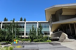
Microsoft Corporation headquarters in Redmond, an Eastside suburb of Seattle
: Microsoft Corporation headquarters in Redmond, an Eastside suburb of Seattle
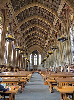
The Suzzallo Library reading room at the state's flagship University of Washington
: The Suzzallo Library reading room at the state's flagship University of Washington
The former offices of the Seattle Post-Intelligencer, a major daily newspaper
: The former offices of the Seattle Post-Intelligencer, a major daily newspaper

Economy and Industry

The Washington State Ferries owns the largest ferry system in the United States.

Washington boasts a robust economy with a median household income of $94,600 (as of 2023), ranking it 7th in the nation. The state is a leader in several key sectors:

  • Technology: Home to major global corporations and innovation hubs.
  • Aerospace: A significant history of aircraft manufacturing and engineering.
  • Agriculture: A vital sector, particularly in the production of apples and wine.
  • Maritime: Extensive use of ferry systems and shipping.
Boeing B-17E Flying Fortress bombers under construction, circa 1942
: Boeing B-17E Flying Fortress bombers under construction, circa 1942
Azwell, WA, a small community of pickers' cabins and apple orchards
: Azwell, WA, a small community of pickers' cabins and apple orchards
Rattlesnake Hills AVA, one of nineteen American Viticultural Areas in the state
: Rattlesnake Hills AVA, one of nineteen American Viticultural Areas in the state.

State Symbols and Culture

Floating bridges on Lake Washington. These are among the largest of their kind in the world.

Washington has a rich array of official symbols that represent its natural beauty and heritage. These include the Western hemlock (state tree), the Rhododendron (state flower), and the Steelhead trout (state fish). The state's culture is also expressed through traditions like square dancing and a vibrant professional sports scene.

Washington's national forests
: Washington's national forests
Black-tailed deer graze at Deer Park in Olympic National Park
: Black-tailed deer graze at Deer Park in Olympic National Park

Summary of State Profile

Washington State Overview
Category Details
Government Governor Bob Ferguson; Capital Olympia
Land Area 66,636 sq mi (Land)
Water Area 4,725 sq mi (6.6%)
Population (2025 est.) 8,001,020
Median Income (2023) $94,600

Frequently Asked Questions

The Washington State Capitol building in Olympia
Two adult women talk with an older white-haired man in camouflage inside a dark room.
U.S. Senators Patty Murray and Maria Cantwell visit Fairchild Air Force Base.
A treemap of the popular vote by county, 2016 presidential election

What is the official language of Washington?

Washington does not have an official language de jure (by law), though English is used de facto (in practice).

What are the major professional sports teams in Washington?

Major teams include the Seattle Seahawks (NFL), Seattle Mariners (MLB), Seattle Kraken (NHL), Seattle Sounders FC (MLS), and the Seattle Storm (WNBA).

How is the state's population distributed?

The population is heavily concentrated in the Puget Sound region, particularly in King County, which contains the state's largest city, Seattle.

What is the significance of the name "Alki"?

"Alki" is a word from Chinook jargon that means "By and By," serving as the official state motto.

Which mountains are prominent in Washington?

Washington is home to several significant peaks, including Mount Rainier, Mount St. Helens, Mount Baker, Glacier Peak, and Mount Adams.