Waiʻaleʻale: Inside One of the Wettest Places on Earth
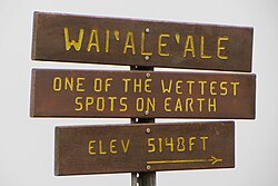
Located on the island of Kauaʻi in the Hawaiian Islands, Mount Waiʻaleʻale is a massive shield volcano that holds a unique distinction in the natural world. Its name, which translates to "rippling water" or "overflowing water," is a fitting description for a summit that is widely recognized as one of the rainiest spots on the planet.
Standing at an elevation of 1,569 meters (5,148 feet), the mountain is the second-highest point on Kauaʻi. While it is famous for its staggering precipitation levels, the landscape is as complex as it is beautiful, shaped by intense weather patterns and unique geological features.
Climate and Rainfall Statistics
The summit of Mount Waiʻaleʻale experiences a tropical rainforest climate (Köppen Af), characterized by substantial and consistent rainfall throughout the entire year. Since 1912, the mountain has averaged more than 373 inches (9,500 mm) of rain annually. The intensity of these storms can be extreme; in 1982, the area recorded a massive 683 inches (17,300 mm) of rainfall.
While Waiʻaleʻale is a premier candidate for the title of the wettest place, recent data from 1978 to 2007 suggests that Big Bog on Maui may hold the title for the wettest spot in Hawaii, with an average of 404 inches (10,300 mm) per year. Despite this, the sheer volume and frequency of rain at Waiʻaleʻale remain legendary.
Monthly Rainfall Breakdown
Rainfall is distributed relatively evenly across the months, though certain periods see significant spikes. For instance, April often sees a dramatic increase in precipitation compared to the surrounding months.
| Month | Average Rainfall (inches) | Average Rainfall (mm) |
|---|---|---|
| January | 24.78 | 629 |
| February | 24.63 | 626 |
| March | 27.24 | 692 |
| April | 47.24 | 1,200 |
| May | 28.34 | 720 |
| June | 30.65 | 779 |
| July | 35.87 | 911 |
| August | 32.75 | 832 |
| September | 24.14 | 613 |
| October | 31.76 | 807 |
| November | 36.33 | 923 |
| December | 30.10 | 765 |
| Annual Total | 373.83 | 9,495 |
Why Does It Rain So Much?
The extreme precipitation at the summit is not a coincidence; it is the result of several converging geographical and meteorological factors:
- Northern Position: Its location relative to the rest of the Hawaiian Islands provides greater exposure to winter frontal systems.
- Trade Wind Inversion: The peak sits just below the trade wind inversion layer (located at approximately 6,000 feet or 1,800 m). This layer acts as a ceiling, preventing trade-wind-produced clouds from rising higher and trapping moisture near the summit.
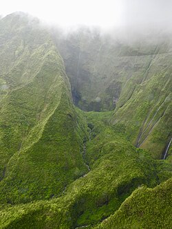
- Topographical Funneling: The summit plateau is surrounded on three sides by steep valleys over 3,000 feet deep. These valleys act as funnels, concentrating moisture-bearing weather systems directly toward the mountain.
- Orographic Lift: As moisture-laden air hits the steep cliffs of the mountain's flanks, it is forced upward rapidly—rising over 4,000 feet in less than half a mile. This process, known as orographic lift, efficiently squeezes moisture out of the clouds, resulting in heavy downpours.
Ecology and the Alakaʻi Wilderness
The relentless rainfall has created a unique and fragile ecosystem. The area is home to the Alakaʻi Wilderness Preserve, a vast, boggy region that supports a variety of rare plant life. Because the ground is perpetually saturated, accessing the Waiʻaleʻale area on foot is extremely difficult, even where trails exist.
This isolation has allowed several endemic species—plants found nowhere else on Earth—to thrive. Some notable species named after the mountain include:
- Astelia waialealae
- Melicope waialealae
- Dubautia waialealae
Key Facts
- Elevation: 1,569 m (5,148 ft).
- Climate Type: Tropical rainforest (Köppen Af).
- Annual Rainfall: Averages over 373 inches (9,500 mm).
- Record Rainfall: 683 inches (17,300 mm) in 1982.
- Primary Feature: A shield volcano and the second-highest point on Kauaʻi.
Frequently Asked Questions
What does the name Waiʻaleʻale mean?
The name literally translates to "rippling water" or "overflowing water."
Is Mount Waiʻaleʻale the wettest place in Hawaii?
While it is one of the wettest spots on Earth and has been promoted as such, data from 1978–2007 indicates that Big Bog on Maui may be the wettest spot in Hawaii.
What is orographic lift?
Orographic lift occurs when air is forced to rise over rising terrain, such as a mountain. As the air rises, it cools and condenses, creating clouds and precipitation.
How difficult is it to hike to the summit?
Access is extremely difficult due to the boggy terrain and the intense, consistent rainfall characteristic of the Alakaʻi Wilderness Preserve.
What is the trade wind inversion?
The trade wind inversion is a layer of air at approximately 6,000 feet that prevents trade-wind-produced clouds from rising higher, effectively trapping moisture at lower altitudes.