U.S. Route 1: The Longest North-South Highway on the East Coast
U.S. Route 1 (US 1) stands as a monumental artery of the American road system. Stretching approximately 2,370 miles (3,810 km), it is the longest north-south highway in the United States, connecting the tropical tip of Florida to the rugged border of Maine. From the sunny shores of Key West to the Canadian crossing at Fort Kent, US 1 serves as a historic link between the major metropolitan hubs of the Eastern Seaboard.
While modern travelers often rely on the high-speed efficiency of Interstate 95 (I-95), US 1 offers a different perspective of the East Coast. Depending on the region, it may run parallel to the interstate, dive deep into inland rural communities, or hug the coastline more closely than the modern freeway system. It connects iconic cities including Miami, Washington, D.C., New York City, and Boston, weaving together the cultural and economic fabric of the Atlantic coast.
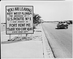
Key Facts
- Total Length: 2,369.49 miles (3,813.32 km).
- Southern Terminus: Fleming Street in Key West, Florida.
- Northern Terminus: Fort Kent, Maine, at the Canadian border.
- Established: November 11, 1926.
- Primary Parallel: Generally paralleled by Interstate 95, though their proximity varies by state.
- Historic Predecessor: Much of the route was originally the Atlantic Highway.
The Evolution of the Route
Before the standardized numbering system of 1926, the path of US 1 was largely defined by the Atlantic Highway, an auto trail established in 1911. In its early days, the route followed the Atlantic Seaboard Fall Line—the geological boundary between the Piedmont plateau and the Atlantic Plain—because the roads further east were often lower quality and avoided major population centers.
Over time, US 1 absorbed several other famous roads, including the Boston Post Road in New England, the Lincoln Highway between New York and Philadelphia, and the Dixie Highway in Georgia. The completion of the Overseas Highway in 1938 extended the route's reach all the way to Key West.

Regional Breakdown
The South: Florida, Georgia, and the Carolinas
In Florida, US 1 begins in Key West and travels north through Miami and Jacksonville. As it enters Georgia and South Carolina, the road's character shifts. In South Carolina, it primarily serves rural areas, functioning as a local two-lane road with occasional boulevards. Between Camden and the North Carolina line, the South Carolina Department of Transportation has no current plans for widening or bypassing the existing alignment.
The Mid-Atlantic: Virginia to Pennsylvania
The Mid-Atlantic section traverses some of the most densely populated regions in the country. In Virginia, the road was historically known as the Jefferson Davis Highway, though as of January 1, 2022, remaining portions were renamed Emancipation Highway. In other areas, it is known as Boydton Plank Road or Richmond Highway.
After crossing the Potomac River into the District of Columbia, US 1 passes through the heart of the capital before entering Maryland. It follows the Baltimore–Washington Boulevard and passes through the University of Maryland, College Park campus. Notably, US 1 bypasses the state of Delaware entirely, unlike I-95.
New England: Connecticut to Maine
In New England, US 1 often functions as a primary surface road for large cities. In Connecticut, it hugs the shore of Long Island Sound. In Rhode Island, it follows Narragansett Bay, transitioning from a limited-access highway to a lower-speed surface road through Providence.
After passing through Boston via the Tobin Bridge and Northeast Expressway, the route enters New Hampshire along the historic Lafayette Road. In Maine, the highway splits from I-95 at Portland, following the "Coastal Route" to Calais before turning west to reach its northern terminus at the Clair–Fort Kent Bridge.
Route Summary Table
| Feature | Details |
|---|---|
| Total Distance | 2,369.49 miles |
| Southern End | Key West, FL |
| Northern End | Fort Kent, ME |
| Major Cities Served | Miami, Jacksonville, Raleigh, Richmond, DC, Baltimore, Philadelphia, NYC, Boston, Portland |
| Key Parallel Interstates | I-95, I-85, I-20 |
Auxiliary Routes
To support the main highway, several auxiliary routes have been established. These include three-digit U.S. routes and state-specific designations:
- US 401: Runs from Sumter, SC to Wise, NC.
- US 701: Runs from Georgetown, SC to Four Oaks, NC.
- Route 1A: Various state-level designations in Florida (SR A1A), Massachusetts, New Hampshire, New York, and Rhode Island.
Frequently Asked Questions
Is US 1 the same as I-95?
No. While they both run north-south along the East Coast and often parallel each other, they are distinct roads. I-95 is a limited-access interstate designed for high-speed travel, whereas US 1 is a U.S. Numbered Highway that often serves as a local main street or surface road.
Where does US 1 end?
US 1 has two termini: the southern end is at Fleming Street in Key West, Florida, and the northern end is at the Fort Kent–Clair Border Crossing in Fort Kent, Maine.
Why does US 1 go inland in some states?
When the route was established in the 1920s, it followed the Atlantic Seaboard Fall Line. At that time, the roads closer to the coast were of lower quality and did not serve as many major population centers as the inland routes.
Does US 1 pass through New York City?
Yes, US 1 passes through New York City, including segments in Manhattan and the Bronx, where it intersects with I-87 and I-95.
What is the "Coastal Route" in Maine?
The Coastal Route is the portion of US 1 in Maine that travels east from Brunswick to Calais, hugging the coastline rather than taking the more direct inland path used by I-95.