Tottenham Court Road: A History of Manors, Markets, and Urbanization
Tottenham Court Road is more than just a bustling thoroughfare in modern London; it is a landscape shaped by centuries of transition from rural manors to a dense urban center. The road derives its name from the Manor of Tottenham Court, a historic estate whose manor house once stood just north of the junction with Euston Road.
The Manor of Tottenham Court
The earliest surviving record of the manor dates back to a charter from approximately AD 1000, where it was referred to as Þottanheale. While the initial 'Þ' (pronounced 'th') may have been a scribal error, all subsequent records transitioned to a 'T'. By the time of the Domesday Book in 1086, the area was recorded as Totehele, evolving into Totenhale by 1184 and Totenhale Court by 1487. It is important to note that while the name shares a root with Tottenham in the London Borough of Haringey, the two locations are not directly related.
Geographically, the manor occupied the south-western portion of the parish of St Pancras. South of Torrington Place, the manor lay between Tottenham Court Road and the boundary of the City of Westminster. North of Torrington Place, the estate spanned both sides of the road. The manor house was situated just north of the site where Euston Road was eventually constructed in 1756.
Ownership of the land shifted through various powerful hands over the centuries. The Domesday Book lists the Dean and Chapter of St Paul's Cathedral as the owners. During the reign of Henry III (1216–1272), a manor house was owned by William de Tottenhall. By the 15th century, the area was known by various names, including Totten, Totham, or Totting Hall. The estate was later leased for 99 years to Queen Elizabeth I, leading to the popular name "Tottenham Court." Following a lease to Charles I in 1639 and his subsequent execution, the land was sold to Ralph Harrison before returning to Crown ownership during the Restoration and being leased to Charles II for 41 years.
Urbanization and Social Evolution
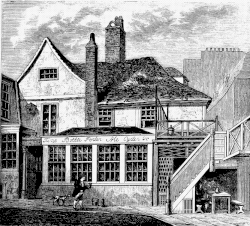
The transition from a rural estate to an urban neighborhood accelerated when the manor became the property of the Fitzroys, Dukes of Grafton. Toward the end of the 18th century, they developed Fitzroy Square on a portion of the estate. The original manor house at the northwest end of the road eventually became the Adam and Eve pub, which was later demolished to make way for the Euston Tower.
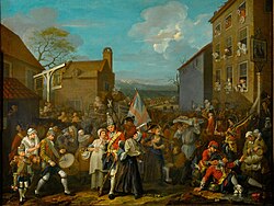
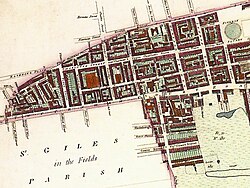
By the mid-17th century, Tottenham Court Road had evolved into a hub for entertainment. Records from 1645 show individuals being fined for drinking on a Sunday, and the area sporadically hosted a Gooseberry Fair featuring street entertainers and booths.
Industrial and religious landmarks soon defined the area. The Horse Shoe Brewery was established in 1764 at the junction of Tottenham Court Road and Oxford Street, with the current Horseshoe pub following in the 19th century. In 1756, the Reverend George Whitefield established Whitefield's Tabernacle. After an extension in 1760, it became the world's largest Methodist church. The building faced numerous setbacks, including a fire in 1857, a collapse in 1888, and bombing during the Second World War, before being rebuilt as the Memorial Chapel.
Despite these developments, rural elements persisted well into the 19th century. For instance, when Heal's was established on former farmland, the lease required the provision of accommodation for 40 cows, though these cowsheds were destroyed by fire in 1877. A 17th-century farmhouse remained at the rear of No. 196 Tottenham Court Road until its demolition in 1917.
The Fairyland Shooting Range
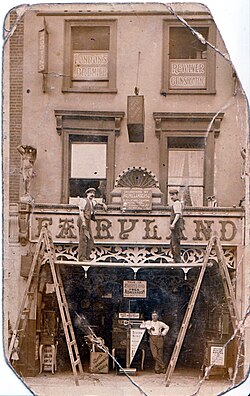
In the early 20th century, No. 92 Tottenham Court Road housed an amusement arcade featuring a miniature rifle-shooting range known as Fairyland, owned by Henry Stanton Morley (1875–1916). This site became a focal point for political violence and legal precedent during the First World War era.
In 1909, Madan Lal Dhingra used the range to practice before assassinating Sir William Hutt Curzon Wyllie. Other members of Abhinav Bharat and residents of India House also used the facility to rehearse planned assassinations. That same year, police investigations suggested that two Suffragettes may have used the range in a conspiracy to assassinate Prime Minister H. H. Asquith.
The range was also the site where Donald Lesbini shot Alice Eliza Storey. The resulting legal case, R v Lesbini (1914), established a significant common law precedent regarding voluntary manslaughter, ruling that a reasonable person always possesses reasonable powers of self-control and is never intoxicated.
Key Facts
- Origin: Named after the Manor of Tottenham Court, first recorded as Þottanheale around AD 1000.
- Ownership: Historically held by St Paul's Cathedral, the Crown (Elizabeth I, Charles I, Charles II), and the Dukes of Grafton.
- Landmarks: Home to the Horse Shoe Brewery (est. 1764) and Whitefield's Tabernacle (est. 1756).
- Urbanization: Remained predominantly rural into the 19th century; Heal's originally required space for 40 cows.
- Legal Precedent: The Fairyland shooting range was the site of the R v Lesbini (1914) case regarding voluntary manslaughter.
| Period/Date | Key Event or Feature | Significance |
|---|---|---|
| c. AD 1000 | First record as Þottanheale | Earliest mention of the manor |
| 1086 | Domesday Book entry | Recorded as Totehele; owned by St Paul's Cathedral |
| 1756 | Construction of Euston Road & Whitefield's Tabernacle | Shift toward urban infrastructure and religious growth |
| Late 18th Century | Development of Fitzroy Square | Urbanization by the Dukes of Grafton |
| 1909 | Fairyland Shooting Range activity | Site of political assassination practice and legal cases |
Frequently Asked Questions
Is Tottenham Court Road related to the area of Tottenham in Haringey?
No. Although they share a similar word root, the two locations are not directly related.
What was the significance of the Fairyland shooting range?
It was used by political activists, including Madan Lal Dhingra and suspected Suffragettes, to practice shooting. It was also the site of a shooting that led to the landmark legal case R v Lesbini (1914).
What happened to the original manor house?
The manor house at the northwest end of the road eventually became the Adam and Eve pub, which was later demolished to make way for the Euston Tower.
How rural was the area in the 19th century?
It remained surprisingly rural; for example, the lease for Heal's required accommodation for 40 cows, and a 17th-century farmhouse stood on the road until 1917.
What was Whitefield's Tabernacle?
Built in 1756 for Reverend George Whitefield, it became the world's largest Methodist church after 1760. After several destructions and rebuilds, it is now the Memorial Chapel.