Timsbury History: From Bronze Age Settlement to Coal Mining Hub
Timsbury is a village with a rich and layered past, evolving from a prehistoric settlement into a prosperous industrial center. Its name has shifted through various forms over the centuries, including Timfborough, Tymmersbarue, Timsbyre (meaning wooded hillside), and Timsbarrow (meaning timbered grove), reflecting its early landscape of forests and groves.
Ancient Roots and the Domesday Book
Human habitation in Timsbury dates back to the Bronze Age. By the time of the Norman Conquest, the village was well-established. The Domesday Book of 1086 provides a detailed snapshot of the settlement, recording that William held Timsbury from the Bishop of Coutance, having been held by Ape before 1066.
The 1086 records indicate a productive agricultural community. The land supported three ploughs and included 26 acres of meadow, as well as livestock consisting of 9 cattle, 14 pigs, 60 sheep, and one cob. The entry also mentions a mill at Radford, located to the south of the village. At this time, the parish was part of the hundred of Chew, a historical administrative division.
The Era of Great Estates
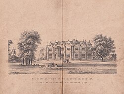
Timsbury was once home to several grand residences, most notably Timsbury House. Built in the late 15th century by Richard Samborne, the mansion was later associated with Barnaby Samborne, who was knighted for his service to Queen Elizabeth I. A unique feature of the estate was its ha-ha—a sunken path designed to provide the family with privacy from locals passing by without obstructing the view of the landscape.
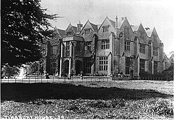
While Timsbury House was demolished in 1961 and replaced by the St. Marys Green and Somerset Folly estates, other historic buildings remain. Pitfour House on the High Street dates to the mid-17th century, and the terrace at Crook Barton was established around 1700.
Notable 19th Century Architecture
- Parish's House: An 1816 extension of an older home, attributed to Thomas Baldwin of Bath for Captain Parish R.N., featuring an ornate balustrade and a contemporary stable block.
- Greenhill House: Built in the early 1800s, this property was originally owned by St Johns Hospital in Bath. It later became part of the Leonard Cheshire Foundation (established in 1976) and is currently known as Leonard Cheshire Disability.
- Renny's and Vale House: Large homes built on Love's Hill during the village's period of industrial prosperity.
The Somerset Coalfield and Industrial Growth
The economic landscape of Timsbury was transformed in 1795 with the opening of the Somerset Coal Canal, which began at Gooseyard bridge. This infrastructure linked the village to the wider market, serving seven key mines within the Somerset Coalfield: Amesbury, Mearns, Tyning, Hayeswood, Old Grove, and the Upper and Lower Conygre pits.
The mining operations varied in longevity. The Amesbury pit operated before 1701, while Hayeswood opened in 1750 and closed in 1862. Tyning opened in 1766, and Mearns operated from 1783 to 1824. The Conygre pits saw significant activity; Upper Conygre began in 1791, and Lower Conygre was sunk in 1847, with the two merging in 1896. By 1908, these were owned by Samborne Smith and Company, and later by Beaumont, Kennedy and Co.
In the early 1900s, the canal was replaced by a railway line, with the Great Western Railway's Radford and Timsbury Halt providing essential passenger transport.
| Mine Name | Opening Date | Closing/Merge Date |
|---|---|---|
| Amesbury | Before 1701 | Early 19th Century |
| Hayeswood | 1750 | 1862 |
| Tyning | 1766 | Not Specified |
| Mearns | 1783 | 1824 |
| Upper Conygre | 1791 | Merged 1896 |
| Lower Conygre | 1847 | Merged 1896 |
Preserving Timsbury's Heritage
In 1978, the village core—specifically the Square and High Street—was designated a conservation area. This status protects buildings constructed from local White Lias stone (a greyish-white limestone) during the 1700s from inappropriate development, although the area is currently listed as "at risk."
The village's industrial legacy is honored at the Miners Memorial Garden near the Square. Established in 1995, the garden commemorates the centenary of the 1895 underground explosion at the Upper Conygre pit, a tragedy that claimed the lives of four horses and seven miners.
Key Facts
- Ancient Origins: Settlement dates back to the Bronze Age and is recorded in the 1086 Domesday Book.
- Industrial Engine: The Somerset Coal Canal (est. 1795) served seven local mines, driving village prosperity.
- Architectural Heritage: Many 18th-century buildings are constructed from local White Lias stone.
- Lost Landmark: Timsbury House, a 15th-century mansion, was demolished in 1961.
- Memorial: The Miners Memorial Garden commemorates a fatal 1895 explosion at Upper Conygre pit.
Frequently Asked Questions
What does the name Timsbury mean?
The village has been known by several names, including Timsbarrow, meaning "timbered grove," and Timsbyre, meaning "wooded hillside."
What was a "ha-ha" at Timsbury House?
A ha-ha is a sunken path or ditch that acted as a barrier to keep local inhabitants away from the house for privacy, without blocking the visual landscape with a fence.
Which mines were part of the Somerset Coalfield in Timsbury?
The area included the Amesbury, Mearns, Tyning, Hayeswood, Old Grove, and Upper and Lower Conygre mines.
What is White Lias stone?
White Lias is a local stone used in the construction of many of Timsbury's 18th-century buildings, which are now protected within the village's conservation area.
Why was the Miners Memorial Garden created?
It was built in 1995 to mark the 100th anniversary of an 1895 explosion at the Upper Conygre pit that killed seven miners and four horses.