Tierra del Fuego: Life at the Edge of the World
Located at the southernmost tip of South America, the Tierra del Fuego archipelago represents one of the most remote and rugged environments on Earth. This vast collection of islands, split between the nations of Chile and Argentina, is a land of dramatic glaciers, windswept forests, and a complex history that stretches from ancient indigenous settlements to the era of European maritime exploration.
The archipelago is dominated by the Isla Grande de Tierra del Fuego, a massive landmass that serves as the heart of the region. To its south lies the famous Beagle Channel, a waterway that separates the main island from smaller, southern islands like Hoste and Navarino. Whether viewed through the lens of its unique subpolar climate or its rich biological diversity, Tierra del Fuego remains a frontier of natural wonder.
Key Facts
- Location: Tip of South America, bordering the Pacific and Atlantic Oceans.
- Political Division: Shared by Chile (western portion) and Argentina (eastern portion).
- Highest Point: Monte Shipton (2,580 metres).
- Climate: Subpolar oceanic (Cfc), characterized by cool summers and wet, mild winters.
- Population: Approximately 201,000 (as of 2022).
- Major Landmark: Cape Horn, located just north of 56° south.
Geography and Climate
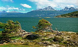
The archipelago's geography is defined by its fragmentation. The Isla Grande de Tierra del Fuego covers 48,100 km², with roughly 61.43% falling under Chilean administration and 38.57% under Argentine control. The southwestern part of the main island is home to the Cordillera Darwin, a mountain range featuring numerous glaciers that flow directly into the ocean.
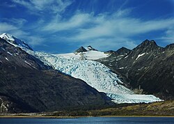
The climate is classified as subpolar oceanic. This means the region experiences short, cool summers and long, wet winters. Precipitation levels vary significantly across the landscape, averaging 3,000 mm annually in the far west before decreasing toward the east. In places like Ushuaia, summer temperatures rarely exceed 9°C (48°F), while winters average around 0°C (32°F). In the southernmost reaches, a sub-antarctic climate prevails, creating a tundra-like environment where tree growth is nearly impossible.
A Journey Through History
Prehistory and Indigenous Cultures
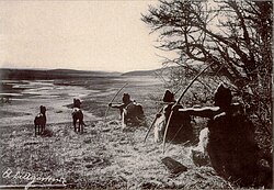
Human presence in Tierra del Fuego dates back to approximately 8,000 BC. Among the earliest known inhabitants were the Yahgan, whose cultural footprints can still be found on Navarino Island. Other significant ethnic groups included the Selkʼnam, Kawésqar, and Yaghans.
European Exploration and the "Land of Fire"
The archipelago's name was inspired by the Portuguese explorer Ferdinand Magellan. During his 1520 expedition, he observed numerous fires burning along the coastline—likely built by indigenous inhabitants for warmth or signaling—leading him to name the region Tierra del Fuego (Land of Fire).
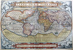
Subsequent explorers further mapped the region. In 1525, Francisco de Hoces speculated that the area consisted of islands rather than a single continent. Later, in 1578, Francis Drake explored these waters, and a 1616 Dutch expedition eventually named Cape Horn after Hornos Island.
In the 19th century, the HMS Beagle played a pivotal role in the region's history. During his 1830 voyage, Captain Robert FitzRoy brought native Fuegians to England, including "Jemmy Button." On a later voyage, Charles Darwin visited the islands, making extensive scientific observations that contributed to his global research.
Colonization and Modern Era
The late 19th century saw a surge in immigration driven by the discovery of placer gold in 1879. This led to the establishment of settlements such as Ushuaia and Río Grande in Argentina, and Porvenir in Chile. Following the Boundary Treaty of 1881, the territory was formally divided between the two nations.
In the mid-20th century, the discovery of oil in northern Tierra del Fuego in 1945 transformed the local economy. Today, energy production remains a cornerstone of the region, with petroleum and natural gas extraction contributing significantly to the economic output of the Argentine side.
Flora and Fauna
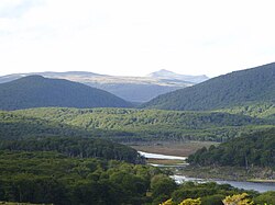
The vegetation of Tierra del Fuego is shaped by its harsh climate. The Nothofagus (southern beech) forests are characteristic of the region, though they are currently threatened by North American beavers, which were introduced in the 1940s and have caused extensive damage to the island's forests.
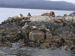
The surrounding waters are incredibly rich in marine life. The region is a prime location for observing various cetaceans, including southern right whales, humpbacks, blue whales, and fin whales. The Beagle Channel is particularly noted for its endemic dolphin species and the rare pygmy right whale.
Summary of Regional Data
| Category | Details |
|---|---|
| Main Island Area | 48,100 km² |
| Chilean Territory | ~61.43% of Isla Grande |
| Argentine Territory | ~38.57% of Isla Grande |
| Highest Elevation | Monte Shipton (2,580 m) |
| Primary Economic Drivers | Energy (Oil/Gas) and Tourism |
Frequently Asked Questions
Why is the region called Tierra del Fuego?
The name means "Land of Fire." It was coined by Ferdinand Magellan after he observed many fires lit by indigenous people along the coastlines during his 1520 expedition.
Which countries claim parts of the archipelago?
The archipelago is divided between Chile and Argentina. The division was formalized following the Boundary Treaty of 1881.
What is the climate like in Tierra del Fuego?
It has a subpolar oceanic climate, meaning it features cool summers, long and wet winters, and relatively steady temperatures throughout the year.
How do beavers affect the local environment?
North American beavers were introduced in the 1940s and have since proliferated, causing significant damage to the native island forests. Governments have implemented programs to manage their population.
What kind of marine life can be seen in the Beagle Channel?
The waters are home to a high diversity of cetaceans, including southern right whales, humpbacks, blue whales, and various species of dolphins.