Tibesti Mountains: The Volcanic Heart of the Sahara Desert
Rising dramatically from the vast expanse of the Sahara, the Tibesti Mountains represent one of the most significant geological formations in North Africa. Spanning an area of approximately 100,000 km², this massive range straddles the borders of Chad and Libya, creating a rugged landscape of volcanic peaks, deep valleys, and extreme environmental contrasts.

The Tibesti is not merely a collection of hills; it is a complex volcanic massif characterized by high elevations and diverse rock formations. With an average elevation of about 2,000 meters, sixty percent of the range sits above 1,500 meters, providing a stark vertical relief against the surrounding desert plains.

Key Facts

- Highest Peak: Emi Koussi (3,415 m / 11,204 ft), the highest point in both Chad and the Sahara Desert.
- Location: Spans the border between Chad and Libya.
- Dimensions: Approximately 480 km long and 350 km wide.
- Geology: Primarily volcanic, featuring rocks like basalt, andesite, and rhyolite.
- Hydrology: Features enneris (seasonal wadis) and geothermal hot springs.
Topography and Major Peaks

The skyline of the Tibesti is dominated by massive shield volcanoes and sharp peaks. At the southern end of the range lies Emi Koussi, a monumental peak reaching 3,415 meters. This summit holds the distinction of being the highest point in the entire Sahara Desert.

Other notable summits contribute to the range's formidable profile:
- Pic Toussidé: 3,296 m
- Tarso Ahon: 3,325 m
- Mouskorbé: 3,376 m
- Timi: 3,012 m
Nearby, across the border in Libya, lies Bikku Bitti, which reaches 2,266 meters and stands as the highest point in Libya. The terrain is a complex network of high plateaus and steep slopes, including prominent features like Tarso Yega and Tarso Voon.

Geology and Volcanic Activity

The geological history of the Tibesti is deeply rooted in volcanic processes dating back to the Oligocene epoch. The landscape is composed of a variety of volcanic rock types, including andesite, basalt, basanite, dacite, ignimbrite, pumice, rhyolite, trachyandesite, and trachyte.

The volcanic nature of the region is evident in the presence of numerous craters and lava fields. For instance, the Tarso Tôh volcanic field contains approximately 150 cinder cones, two maars (low-relief volcanic craters formed by explosions), and several basalt lava channels.

More recent volcanic activity is visible in the dark, stark landscapes of the newer lava rocks, particularly around the Toussidé volcano and the Trou au Natron crater.

Hydrology: The Enneris and Hot Springs

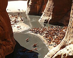
Water in the Tibesti is a precious and highly variable resource. The mountains feature enneris, which are seasonal riverbeds or wadis. These channels are primarily fed by periodic storms that sweep across the mountains. The flow of these wadis can be extreme; the Bardagué wadi, for example, has recorded massive flows of 425 m³/s, yet has also endured years of total drought.

Beyond surface water, the region exhibits significant geothermal activity. The Yi Yerra hot springs, located on the southern flank of Emi Koussi, emit water at 37 °C (99 °F). Additionally, the Soborom geothermal field near Tarso Voon features a dozen springs with temperatures ranging from 22 °C to 88 °C (72 to 190 °F).
Climate and Environment

The climate of the central Tibesti is characterized by extreme temperature fluctuations. While average monthly maximums hover around 28 °C (83 °F), nighttime temperatures can plummet to −10 °C (14 °F). The combination of high heat and low humidity leads to massive evaporation rates, often parching the enneris before they can reach lower elevations.
| Month | Mean Daily Max (°C) | Daily Mean (°C) | Mean Daily Min (°C) |
|---|---|---|---|
| Jan | 18.1 | 10.3 | 2.6 |
| Apr | 29.8 | 21.0 | 12.4 |
| Jul | 35.7 | 27.0 | 18.8 |
| Oct | 28.6 | 20.7 | 12.9 |
Summary of Tibesti Geography

| Feature | Details |
|---|---|
| Highest Point | Emi Koussi (3,415 m) |
| Primary Rock Types | Basalt, Andesite, Rhyolite |
| Water Features | Enneris (Wadis), Geothermal Springs |
| Total Area | 100,000 km² |
Frequently Asked Questions


What is the highest peak in the Tibesti Mountains?
The highest peak is Emi Koussi, which reaches an elevation of 3,415 meters (11,204 ft). It is also the highest point in the Sahara Desert.
What are enneris?
Enneris are the seasonal wadis or dry riverbeds found within the Tibesti Mountains. They carry water primarily during periodic storm events.
Is there volcanic activity in the Tibesti?
Yes, the range is a volcanic massif. It contains various features including shield volcanoes, cinder cones, maars, and lava channels composed of rocks like basalt and trachyte.
What kind of climate does the Tibesti region have?
The region has an arid climate with high evaporation rates. It experiences hot days and can have very cold nights, with temperatures sometimes dropping to −10 °C.
Where can geothermal activity be found in the mountains?
Geothermal activity is present in the Yi Yerra hot springs and the Soborom geothermal field, where water temperatures can reach up to 88 °C.