Exploring the Maritimes: A Journey Through Canada's Atlantic Coast
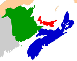
Nestled along the rugged Atlantic coast of Eastern Canada, the Maritimes represent a region defined by deep historical roots, diverse cultures, and a profound connection to the sea. Comprising the provinces of New Brunswick, Nova Scotia, and Prince Edward Island, this region serves as a vital part of Atlantic Canada. From the ancient traditions of Indigenous peoples to the complex colonial struggles between France and Britain, the Maritimes offer a rich tapestry of stories that have shaped the very foundation of the Canadian nation.
Key Facts
- Composition: Three provinces—New Brunswick, Nova Scotia, and Prince Edward Island.
- Total Population: 1,899,324 (as of 2021).
- Total Area: 130,017.11 km².
- Largest Metro Area: Halifax.
- Time Zone: Atlantic Time (UTC−4:00; UTC−3:00 during Daylight Saving Time).
- Indigenous Heritage: Home to the Mi'kmaq, Wolastoqiyik, and Passamaquoddy peoples.
Geography and Climate
The Maritimes are strategically located northeast of New England, south of Quebec's Gaspé Peninsula, and southwest of Newfoundland. The region's geography is heavily influenced by its proximity to the Atlantic Ocean, featuring significant aquatic sub-basins such as the Gulf of Maine and the Gulf of St. Lawrence.
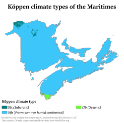
The climate varies across the provinces, with coastal areas experiencing maritime influences. While summers can be pleasantly warm, winters can be quite cold, particularly in inland areas like Campbellton, New Brunswick. Understanding these patterns is essential for grasping the region's agricultural and maritime history.
Regional Climate Comparison
| City | Province | July Avg (°C/°F) | January Avg (°C/°F) |
|---|---|---|---|
| Halifax | Nova Scotia | 23 / 73 | 0 / 32 |
| Fredericton | New Brunswick | 25 / 77 | −4 / 25 |
| Charlottetown | Prince Edward Island | 23 / 73 | −3 / 27 |
| Sydney | Nova Scotia | 23 / 73 | −1 / 30 |
A Deep History: From Ancient Roots to Colonial Conflict
Indigenous Foundations
Long before European arrival, the Maritimes were inhabited by First Nations peoples. Following the retreat of glaciers approximately 10,000 years ago, Paleo-Indians settled the region during the Early Period. By 6,000 years ago, the Middle Period began, characterized by rising sea levels and the emergence of the Laurentian tradition among Archaic Indians. Archaeological evidence, such as burial mounds in the Saint John River valley, provides a glimpse into these ancient societies.
The Era of Acadia and European Contact
The 17th and 18th centuries saw the Maritimes become a geopolitical battleground between England and France. The region of Acadia was a central focus of these tensions. In 1621, France ceded Acadia to Scotland's Sir William Alexander, who renamed the territory Nova Scotia. However, the territory was returned to France in 1632 under the Treaty of Saint-Germain-en-Laye.

French settlers from regions like Brittany and Normandie populated Acadia, establishing communities in the Saint John River valley and the Isthmus of Chignecto. However, the stability of these settlements was constantly threatened by colonial wars between New England and Acadia.
The Expulsion and the Fall of French Control
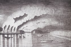
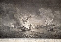
The conflict reached a breaking point during the mid-18th century. In 1755, the British began the Expulsion of the Acadians, a period of forced removal that saw over 12,000 Acadians displaced from Nova Scotia. The fall of the French presence was cemented by the Siege of Louisbourg in 1758, where a massive British force of 27,000 soldiers and sailors successfully captured the fortress.
The Path to Confederation
The Impact of the American Revolution
The American Revolutionary War brought further upheaval. While the Maritimes were not the primary theater of war, coastal communities faced raids, and the capital of St. John's Island (now Prince Edward Island), Charlottetown, was ransacked in 1775. The most significant long-term impact was the arrival of Loyalist refugees—settlers who remained loyal to the British Crown—which significantly increased the population of the region.
The Birth of Canada
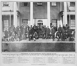
By the mid-19th century, political shifts and economic concerns led to a movement for unity. In 1864, the Charlottetown Conference was held to discuss a Maritime Union. These discussions were instrumental in the creation of the Canadian Confederation. While the Maritimes entered Confederation as distinct provinces, their economic trajectories began to diverge from the rest of the growing nation.
Economic Evolution: From "Golden Age" to Modern Challenges
The Myth and Reality of the Golden Age
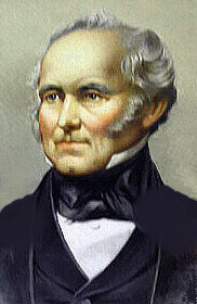
Historians often debate the "Golden Age" of the Maritimes in the 1850s and 1860s. While the era saw a booming international shipping industry and a strong manufacturing sector, recent scholarship suggests this prosperity was unevenly distributed. While an urban elite in cities like Halifax flourished, many rural families—farmers, fishermen, and laborers—continued to live in poverty.
Industrial Shifts and Economic Decline
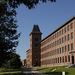
The transition from a manufacturing hub to an economic hinterland is a complex historical subject. Several factors contributed to this shift, including the implementation of the National Policy (a system of protective tariffs) and significant technological changes in transportation. By the early 20th century, many local industries struggled to compete with more centralized operations in Quebec and Ontario.
Today, the Maritimes remain a region of distinct cultural identities, reflected in their linguistic diversity and heritage. From the Celtic influences of Scottish and Irish migrants to the enduring presence of Black Canadians and Indigenous communities, the region continues to evolve.
Frequently Asked Questions
What provinces make up the Maritimes?
The Maritimes consist of three Canadian provinces: New Brunswick, Nova Scotia, and Prince Edward Island.
Who are the Indigenous peoples of the Maritimes?
The Mi'kmaq, Wolastoqiyik, and Passamaquoddy are the Indigenous peoples native to the Maritime region.
What was the Expulsion of the Acadians?
The Expulsion of the Acadians was a period beginning in 1755 when British forces forcibly removed over 12,000 Acadian settlers from Nova Scotia.
How did the Maritimes join Canada?
The Maritimes were involved in the discussions at the 1864 Charlottetown Conference, which contributed to Canadian Confederation. Nova Scotia and New Brunswick joined in 1867, followed by Prince Edward Island in 1873.
What is the largest city in the Maritimes?
Halifax, located in Nova Scotia, is the largest metropolitan area in the region.