Te Ara ki Uta ki Tai: From Proposed Motorway to Shared Pathway
The evolution of the Eastern Transport Corridor in Auckland reflects a significant shift in urban planning, moving from high-capacity vehicle infrastructure to sustainable, active transport. What began as a proposal for a massive motorway has transformed into Te Ara ki Uta ki Tai, a dedicated shared pathway designed to connect communities while preserving the environment.
The Failed Motorway Proposal
In 2002, a strategy study identified the need for a new motorway within the corridor to reduce pollution and increase safety on suburban streets. By March 2004, Auckland City Mayor John Banks proposed a specific scheme that would have routed a motorway through Hobson Bay.
The proposal faced intense political and community opposition. Critics cited the immense financial burden—estimated at a cost equivalent to four years of the entire country's transport funding budget—and the potential destruction of established neighborhoods. Key areas of concern included Tamaki Drive, the Parnell Baths, and various environmentally sensitive zones.
Despite attempts to revise the designs, costs continued to climb, reaching a worst-case estimate of NZ$3.9 billion. Consequently, on December 10, 2004, the Auckland City Council transport and urban linkages committee scrapped the motorway plan, opting instead to focus on increased capacity for local roads and improved public transport.
The Transition to a Shared Pathway
A decade later, in June 2014, Auckland Transport and Waka Kotahi (the New Zealand Transport Agency) announced a new vision for the corridor: a "Metro-style" shared pathway. This design ensures total segregation from vehicle traffic, providing a safe, off-road route as part of the broader Auckland Cycling Network.
Initially planned as a five-stage project between Mechanics Bay and Glen Innes, the scope was refined by November 2014. The updated plan reduced the project to four sections, shifted the terminus from Mechanics Bay to Tamaki Drive, and estimated a total cost of approximately $30 million.
Route and Development
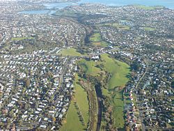
The pathway was designed to run from the Glen Innes railway station through Apirana Reserve to St Johns Rd, entering the Pourewa Valley. The route crosses to the southern side of the tracks near Purewa Cemetery, continuing to Orakei Rd before crossing back to the northern side to reach Tamaki Drive. While the railway alignment was the primary plan, the final section (Stage 4) was eventually rerouted to follow Ngapipi Rd.
Construction progressed in phases, though it faced several hurdles:
- Section 1: Running from Merton Rd in Glen Innes to St Johns Rd, this section opened on December 9, 2016.
- Section 3: Involving adjustments to the Ōrākei Basin boardwalk, this section opened in July 2019.
- Section 2: Connecting Meadowbank railway station to St Johns Rd, this section was delayed by funding constraints and the COVID-19 pandemic, eventually opening in May 2022.
- Section 4: Construction began in January 2022, with a projected opening in early 2023 subject to consent.
Upon the opening of Section 1 in 2016, Mana whenua (local indigenous people with ancestral ties to the land) gifted the pathway its official name: Te Ara ki Uta ki Tai.
Key Facts
- Official Name: Te Ara ki Uta ki Tai (gifted by Mana whenua).
- Original Motorway Cost Estimate: Up to NZ$3.9 billion.
- Pathway Project Cost: Approximately $30 million.
- Pathway Type: Metro-style (totally segregated from traffic).
- Primary Route: Glen Innes railway station to Tamaki Drive.
- Key Milestones: Section 1 opened Dec 2016; Section 3 opened July 2019; Section 2 opened May 2022.
Project Summary
| Feature | Proposed Motorway (2004) | Shared Pathway (2014+) |
|---|---|---|
| Primary Goal | Vehicle capacity & suburban safety | Active transport & cycling network |
| Estimated Cost | Up to NZ$3.9 billion | ~$30 million |
| Environmental Impact | High (Hobson Bay, Parnell Baths) | Low (Off-road, segregated path) |
| Outcome | Scrapped by Auckland City Council | Completed in multiple sections |
Frequently Asked Questions
Why was the proposed motorway through Hobson Bay cancelled?
The motorway was scrapped due to substantial community and political resistance caused by its extreme cost—which would have consumed four years of the national transport budget—and its negative impact on established neighborhoods and environmentally sensitive areas.
What does "Metro-style" mean in the context of the pathway?
A Metro-style path refers to a high-quality cycling and walking route that is totally segregated from vehicle traffic, utilizing off-road routes to ensure user safety.
Who named the pathway Te Ara ki Uta ki Tai?
The name was gifted by Mana whenua to coincide with the opening of the first section of the pathway in December 2016.
Which sections of the pathway experienced delays?
Section 2 (between Meadowbank railway station and St Johns Rd) and Section 4 experienced delays due to funding constraints, with Section 2 further delayed by the COVID-19 pandemic.
Where does the pathway currently end?
The pathway connects Glen Innes railway station to Tamaki Drive, passing through key points such as the Pourewa Valley and Ngapipi Rd.