Sydling Water: A Pristine Chalk Stream of Dorset
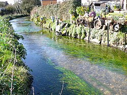
Nestled in the scenic landscapes of Dorset, England, the Sydling Water is a classic example of a chalk stream—a rare type of river fed by groundwater filtering through porous limestone and chalk. Stretching approximately 8 kilometers (5 miles), this waterway carves a peaceful path through the rural countryside, offering a glimpse into the natural beauty and agricultural heritage of the region.
The Course of the River
The journey of the Sydling Water begins at a spring in Up Sydling. From its source, the river flows in a northerly to southerly direction, winding through a landscape marked by both historical remnants and natural splendor.
As it travels south, the stream passes the deserted medieval village of Elston. One of its notable crossings occurs at a ford located on the road connecting Marrs Cross to Cerne Abbas. The river then meanders through the picturesque village of Sydling St Nicholas, where the local "valley road" closely mirrors the river's path as it continues toward its destination.
The river's journey concludes after it passes beneath the imposing Grimstone Viaduct, shortly after which it merges with the River Frome near Grimstone.
Key Facts
- Total Length: Approximately 8 km (5 miles).
- Location: Dorset, England.
- Source: A spring at Up Sydling.
- Termination: Joins the River Frome near Grimstone.
- Key Landmarks: Elston (deserted medieval village) and Grimstone Viaduct.
Ecology and Local Industry
The Sydling Water is highly regarded for its clear, mineral-rich waters, which support a specific ecosystem and local economy. The river is particularly well-known for its watercress farms, as the alkaline conditions of chalk streams are ideal for this crop.
For nature enthusiasts and anglers, the river is a haven. It is renowned for its trout populations, making it a point of interest for fishing. Additionally, the riverbanks are frequent haunts for avian wildlife, with grey herons and little egrets commonly spotted hunting along the water's edge.
| Feature | Details |
|---|---|
| River Type | Chalk Stream |
| Length | 8 km (5 mi) |
| Primary Wildlife | Trout, Grey Herons, Little Egrets |
| Agricultural Use | Watercress farming |
| Confluence | River Frome |
Frequently Asked Questions
Where does the Sydling Water begin and end?
The river originates from a spring at Up Sydling and flows south until it joins the River Frome near Grimstone.
What is a chalk stream?
A chalk stream is a river fed by groundwater that has filtered through chalk rock, resulting in clear, alkaline water that is rare globally.
Which villages does the Sydling Water pass through?
The river passes through Up Sydling, the deserted medieval village of Elston, and the village of Sydling St Nicholas.
What wildlife can be seen along the Sydling Water?
Common sightings include trout in the water, as well as grey herons and little egrets along the banks.
What are the primary economic uses of the river?
The river is notably used for watercress farming and is known for its trout.