Sudbury Highway Bypasses: A History of Regional Infrastructure
The evolution of transportation in Sudbury is a story of transitioning from congested city streets to a streamlined network of bypasses. For decades, the city served as a primary transit hub where major provincial arteries converged, forcing long-distance travelers to navigate the heart of the urban center. To alleviate this pressure, a series of strategic bypass projects were implemented over several decades.
The Original Route Through Downtown
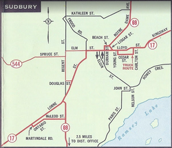
Before the implementation of modern bypasses, Highway 17 and Highway 69 functioned as the primary conduits for traffic entering Sudbury. Highway 17 entered the city from the west via what is now Municipal Road 55 (Lorne Street), while Highway 69 arrived from the south via what is now Municipal Road 46 (Regent Street). These two routes intersected and ran concurrently along Lorne Street into the downtown core.
Once in the city center, the paired highways turned east onto Elm Street. At the site now occupied by the Rainbow Centre Mall, Highway 69 split north onto Notre Dame Avenue (Municipal Road 80), while Highway 17 continued its eastward journey along Lloyd Street and Kingsway toward Coniston.
The Development of the Southwest Bypass
The need for a more efficient route became evident in 1967, when the "Planning Study for the Sudbury Southwest By-Pass" determined that a four-lane highway surrounding the city would be necessary in the near future. Following a subsequent study in 1973 focusing on the Sudbury-North Bay area, construction began on the 13.0-kilometre (8.1 mi) Southwest Bypass.
This two-lane route, which connected Highway 17 near Lively with Highway 69 south of the urban area, was officially opened on October 11, 1974. The project cost C$3.9 million (approximately $24.4 million in 2025 dollars) and was designated within the provincial system as the unposted Highway 7153.
Expanding the Corridor: Lively to Whitefish
Between 1974 and 1975, further studies were conducted along the Sudbury–Sault Ste. Marie corridor to identify where four-lane expansions were most critical. This led to the 1976 commencement of a 19.7-kilometre (12.2 mi) four-lane bypass of Highway 17, stretching between Lively and the area west of Whitefish.
Connecting with the western terminus of the Southwest Bypass, this expanded route opened to traffic on December 4, 1980. The total cost for this phase of construction was $30 million (approximately $112 million in 2025 dollars).
The Southeast Bypass and Modern Upgrades
The final major piece of the bypass puzzle began in July 1992 with the construction of the Southeast Bypass. To ensure that future expansions to four lanes would not cause traffic interruptions, the project included a strategic interchange at Highway 69. This two-lane route was opened on November 9, 1994.
Infrastructure improvements continued into the 21st century. In June 2007, work began to replace the signalized intersection at Long Lake Road with a grade-separated interchange—a junction where one road passes over or under another to eliminate the need for traffic lights. This interchange was completed and opened in December 2008.
Key Facts
- Original Routes: Highway 17 and 69 previously converged on Lorne Street and Elm Street in downtown Sudbury.
- Southwest Bypass: Opened October 11, 1974, costing C$3.9 million.
- Lively-Whitefish Segment: A 19.7-km four-lane section opened December 4, 1980, costing $30 million.
- Southeast Bypass: Opened November 9, 1994, featuring a future-proof interchange at Highway 69.
- Long Lake Road: Transitioned from a signalized intersection to a grade-separated interchange in December 2008.
| Project | Opened | Length/Type | Original Cost |
|---|---|---|---|
| Southwest Bypass | Oct 11, 1974 | 13.0 km (2-lane) | C$3.9 Million |
| Lively to Whitefish | Dec 4, 1980 | 19.7 km (4-lane) | $30 Million |
| Southeast Bypass | Nov 9, 1994 | 2-lane | Not Specified |
| Long Lake Rd Interchange | Dec 2008 | Grade-separated | Not Specified |
Frequently Asked Questions
Which streets did Highway 17 and 69 use before the bypasses?
Highway 17 used Lorne Street (now Municipal Road 55) and Highway 69 used Regent Street (now Municipal Road 46). They ran concurrently along Lorne Street and Elm Street before splitting again.
When was the Southwest Bypass opened?
The Southwest Bypass was ceremonially opened by the Highways minister on October 11, 1974.
What was the cost of the Lively to Whitefish four-lane project?
The project cost $30 million, which is equivalent to approximately $112 million in 2025 dollars.
What is a grade-separated interchange?
A grade-separated interchange is a road junction designed to eliminate intersections at the same level, typically using bridges or underpasses to allow traffic to flow without stopping at signals.
When was the Long Lake Road intersection upgraded?
Construction on the grade-separated interchange at Long Lake Road began in June 2007 and the project opened in December 2008.