Stephen H. Long Expedition: Mapping the Great American Desert
In 1820, a specialized group of scientists and soldiers embarked on a journey that would forever change the American perception of the West. Unlike the primarily military explorations of Lewis and Clark or Zebulon Pike, the Stephen H. Long Expedition was the first scientific party commissioned by the United States government to systematically explore the Great Plains and the foothills of the Rocky Mountains.
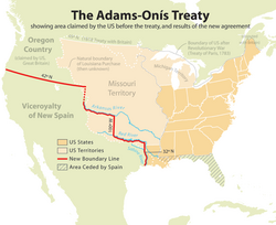
This mission was born out of shifting geopolitical landscapes and economic realities. Originally part of a larger, more ambitious plan known as the Yellowstone expedition, the project was scaled back following the Panic of 1819 and the negotiation of the Adams–Onís Treaty, which redefined the border between the United States and New Spain. What remained was a focused, scientific reconnaissance led by Major Stephen Harriman Long.
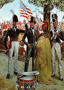
Key Facts
- Leader: Major Stephen Harriman Long, a topographical engineer.
- Primary Objective: To document natural resources, map the Great Plains, and study the customs of Native American nations.
- Timeline: The main expedition traversed the plains from June 6 to September 13, 1820.
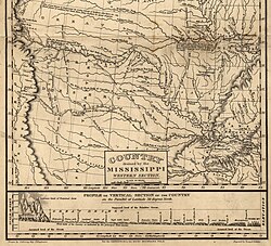
- Major Discovery: The expedition famously labeled the region the "Great American Desert."
- Scientific Legacy: Collected hundreds of new plant species, thousands of insects, and dozens of rare animal skins.
Background and the Shift in Mission
The path to the Great Plains was paved with logistical challenges. The original plan involved using steamboats to navigate the upper Missouri River to establish military outposts. Long himself designed a vessel, the Western Engineer, specifically for these shallow waters.
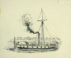
However, the expedition faced significant setbacks. Financial crashes, operational scandals, and the failure of steamboats led to budget cuts. Furthermore, the Adams–Onís Treaty changed the strategic focus of the U.S. government, making it more vital to understand the routes along the Platte River toward the Rocky Mountains and the southern territories near the Arkansas and Red Rivers.
Consequently, the scientific team was reassigned to Long's scaled-down mission. While they lacked the massive manpower and supplies of the original plan, they carried a heavy intellectual burden: to act as the eyes and ears of a nation eager to understand its expanding frontier.
The Journey Across the Plains
Setting out from the Missouri River near present-day Omaha, Nebraska, the party moved southwest. The expedition was a disciplined operation; the group rose at 5:00 a.m. daily, covering 20 to 30 miles by horseback. They navigated through treeless prairies, enduring intense thunderstorms and the vast, open landscape of the Nebraska plains.
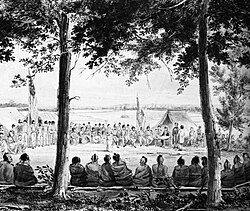
As they moved toward the South Platte River, the team encountered immense natural spectacles, including a herd of at least 10,000 bison. The scientists, including botanist Dr. Edwin James and zoologists Titian Peale and Thomas Say, worked tirelessly to document the flora and fauna. They recorded species such as pronghorns, elk, prairie dogs, and various birds, including the Bartram's sandpiper.
Reaching the Rocky Mountains and Pikes Peak
By late June, the expedition reached the Front Range of the Rocky Mountains. The landscape shifted from the arid plains to the rugged beauty of the mountains. The team explored areas such as Waterton Canyon and the foothills near present-day Colorado Springs, where they documented the columbine, which would later become the Colorado state flower.
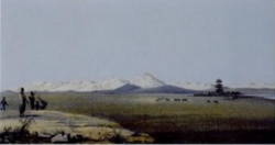
A landmark moment occurred when Dr. Edwin James became the first white person to climb a mountain of 14,000 feet in North America: Pikes Peak. Climbing through alpine tundra, James observed unique high-altitude vegetation and a climate vastly different from the valley below. The expedition also captured the "grand and romantic scenery" of locations like the Royal Gorge along the Arkansas River.
Hardships and Scientific Collections
The expedition was not without extreme suffering. As they moved through the semi-arid regions of Colorado and Oklahoma, the men faced intense heat, drought, and a lack of potable water. At times, the party was forced to survive on meat from owls, badgers, skunks, and horses due to food shortages.
Despite these trials, the scientific output was monumental. The team successfully compiled a massive archive of the American West:
- Over 60 prepared skins of new or rare animals.
- Between 400 and 500 plant species new to the United States.
- Several thousand insect specimens.
- Extensive collections of fossils, minerals, and shells.
- Detailed landscape illustrations by Samuel Seymour and sketches by Titian Peale.
Summary of Expedition Findings
| Category | Key Findings/Details |
|---|---|
| Geographic Label | The Great American Desert |
| Botanical Impact | 400–500 new plant species recorded |
| Zoological Impact | 60+ rare animal skins and thousands of insects |
| Major Landmark | First ascent of Pikes Peak (14,000 ft) |
| Termination Point | Fort Smith, Arkansas |
Frequently Asked Questions
Why did Long call the region the "Great American Desert"?
Long observed the semi-arid, barren nature of the plains during a particularly dry period. He concluded the land was not suited for agriculture, a view that was later complicated by the advent of deep-well drilling and barbed wire technology.
How did this expedition differ from Lewis and Clark?
While Lewis and Clark were primarily a military expedition focused on exploration and sovereignty, the Long Expedition was specifically designed as a scientific reconnaissance to document the natural history and resources of the territory.
Who was the first person to climb Pikes Peak?
Dr. Edwin James, the expedition's physician and botanist, was the first white person recorded to have climbed the 14,000-foot peak, ascending through alpine fields and tundra.
What were the main challenges faced by the team?
The team struggled with extreme temperatures, lack of reliable water, food shortages that forced them to eat unconventional animals, and the physical toll of traveling through rugged, desert-like terrain.
What was the significance of the Adams–Onís Treaty to this mission?
The treaty established a new border between the U.S. and Spain, which shifted the government's priorities from building military posts along the upper Missouri to understanding the routes leading toward the Rocky Mountains and the Spanish colonies.