SR 178: A Route Through Virginia's Eastern Shore
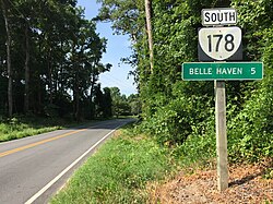
State Route 178 (SR 178) serves as a vital connector across the scenic landscapes of Virginia's Eastern Shore. Stretching from the town of Exmore to the community of Bobtown, this highway winds through various hamlets and crosses county lines, providing essential access to local villages and landmarks.
Route Overview and Path
The journey of SR 178 begins in Exmore at the intersection with US 13 Business. From this starting point, the highway travels along a two-lane undivided stretch of Main Street. As it progresses, it intersects with US 13 (Lankford Highway), where the road transitions into Belle Haven Road.
As the route moves north, it crosses the boundary between the towns of Exmore and Belle Haven, as well as the county line separating Northampton and Accomack counties.
Navigating Belle Haven and Beyond
In the heart of Belle Haven, SR 178 meets the western terminus of SR 181 (King Street). At this junction, the highway turns west onto Shields Bridge Road to cross Occohannock Creek via the Shields Bridge.
From the bridge, the route veers north, passing through the small hamlets of Shields and Craddockville. It then continues northeast along Boston Road, traversing the communities of Boston and Pennyville.
The Final Stretch to Bobtown
Upon reaching the southern edge of Pungoteague, the highway is renamed Bobtown Road. While passing through the village, the route skirts St. George's Church and shares a brief concurrency—a section where two highway designations overlap—with SR 180. SR 180 diverges from this point, heading northwest as Harborton Road and southeast as Pungoteague Road.
SR 178 reaches its northern terminus in Bobtown at the intersection of SR 620 (Hollies Church Road) and SR 628 (Country Club Road). Beyond this point, the roadway continues north toward Onancock, transitioning into SR 718.
Key Facts
- Starting Point: Intersection with US 13 Business in Exmore.
- Ending Point: Intersection with SR 620 and SR 628 in Bobtown.
- Counties Traversed: Northampton and Accomack.
- Major Water Crossing: Occohannock Creek via Shields Bridge.
- Key Intersections: US 13, SR 181, and SR 180.
Route Summary Table
| Location/Segment | Road Name |
|---|---|
| Exmore | Main Street |
| Exmore to Belle Haven | Belle Haven Road |
| Belle Haven Crossing | Shields Bridge Road |
| Boston and Pennyville | Boston Road |
| Pungoteague to Bobtown | Bobtown Road |
Frequently Asked Questions
Where does SR 178 begin?
SR 178 begins at the intersection with US 13 Business in the town of Exmore.
Which counties does SR 178 pass through?
The highway crosses the boundary between Northampton County and Accomack County.
What bridge does SR 178 cross?
The highway crosses Occohannock Creek using the Shields Bridge while traveling on Shields Bridge Road.
Does SR 178 overlap with any other state routes?
Yes, it has a very short concurrency with SR 180 within the village of Pungoteague.
Where is the northern terminus of SR 178?
The route ends in Bobtown at the intersection of SR 620 (Hollies Church Road) and SR 628 (Country Club Road).