Sprague Avenue: A Comprehensive Route Guide Through Spokane and Beyond
Sprague Avenue serves as a vital transportation artery across the Inland Northwest, stretching from the urban core of Downtown Spokane through the expanding suburbs of Spokane Valley and into the rural reaches of Spokane County. From its role as a cultural corridor in the city center to its function as a high-capacity arterial in the valley, Sprague Avenue reflects the evolving urban planning and economic goals of the region.
Sprague Avenue in Spokane
In the city of Spokane, Sprague Avenue connects the eastern border with Spokane Valley to its western terminus at Riverside Avenue, adjacent to the Maple Street Bridge. The route is divided into two distinct operational segments based on traffic flow.
The Downtown Core
For 0.75 miles (1.21 km), beginning at Bernard Street in front of the Spokane Intermodal Center, Sprague operates as a one-way street carrying westbound traffic. This segment passes through the heart of Downtown, serving several landmark locations including:
- The Ridpath Club Apartments
- STA Plaza
- The Davenport Hotel
- The Bing Crosby Theater
- The Fox Theater
- KHQ-TV studios
University District and East Central
East of Bernard Street, the road transitions into a two-way street. It traverses the University District and the East Central neighborhood. To stimulate economic development, the City of Spokane has implemented streetscape renovations along much of this section, mirroring successful revitalization efforts seen in the South Perry District and Market Street in Hillyard.
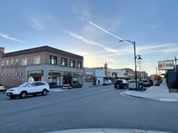
The Spokane Valley Arterial and the Couplet System
As Sprague Avenue enters Spokane Valley, its function shifts to a major arterial. For approximately 2.5 miles (4.0 km), from the I-90 interchange eastward to University Road, it operates as part of a one-way couplet—a pair of parallel one-way streets designed to handle high traffic volumes. In this system, Sprague Avenue carries westbound traffic, while Appleway Boulevard, located one block to the south, carries eastbound traffic.
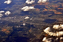
Constructed by Spokane County in 2000 to reduce congestion on Interstate 90, Appleway Boulevard was built using the former right of way of the Milwaukee Railroad. However, this design has been a point of local contention. Business owners argued that the couplet reduced accessibility to storefronts on Sprague, leading to economic decline for some establishments.
While some city and business leaders advocated for returning Sprague to a two-way street, others proposed extending the couplet toward Liberty Lake. As of 2020, the original couplet remains in place, and much of the planned eastern extension has been converted into a pedestrian trail.
The final 1.7 miles (2.7 km) of Sprague in Spokane Valley functions as a local collector roadway, with Appleway Boulevard assuming the primary arterial role as it branches northeast toward Liberty Lake.
Extensions in Liberty Lake and Western Spokane County
Due to local topography, the segment of Sprague Avenue in Liberty Lake is non-contiguous with the Spokane Valley portion. Here, it serves as a local collector road for residential areas on the northern shore of the lake and marks the southern boundary of the Liberty Lake Golf Course.
Further west in Spokane County, several disconnected segments maintain the Sprague name and house numbering system. In Airway Heights, Sprague Avenue acts as a local collector providing access to:
- Northern Quest Resort & Casino
- Spokane County Raceway
- Geiger Corrections Center
- Airway X Motocross Park
Beyond Airway Heights, the route becomes Sprague Road, an unpaved farm access road that continues until it reaches the Lincoln County border.
Key Facts
- Downtown Segment: 0.75 miles of one-way westbound traffic.
- The Couplet: A 2.5-mile system where Sprague (westbound) and Appleway Blvd (eastbound) split traffic.
- Origin of Appleway: Built in 2000 on the former Milwaukee Railroad right of way.
- Liberty Lake: A non-contiguous segment serving the lake's northern shore.
- Western Terminus: Transitions to an unpaved road (Sprague Road) leading to the Lincoln County border.
Route Summary Table
| Location | Road Type | Traffic Flow | Key Feature/Landmark |
|---|---|---|---|
| Downtown Spokane | Urban Street | One-way (West) | The Davenport Hotel |
| East Central/University | Urban Street | Two-way | Revitalized streetscapes |
| Spokane Valley | Major Arterial | One-way (West) | I-90 Interchange |
| Liberty Lake | Local Collector | Two-way | Liberty Lake Golf Course |
| Airway Heights | Local Collector | Two-way | Northern Quest Resort |
| Western County | Farm Road | Two-way | Lincoln County Border |
Frequently Asked Questions
What is the one-way couplet in Spokane Valley?
The couplet is a traffic management system where Sprague Avenue carries all westbound traffic and Appleway Boulevard carries all eastbound traffic for about 2.5 miles to alleviate congestion on I-90.
Why was the couplet system controversial?
Many local business owners felt that the transition from a two-way street to a one-way couplet made their businesses harder to access, which negatively impacted their revenue.
Is Sprague Avenue a continuous road?
No. It is non-contiguous in Liberty Lake due to topography, and it exists as several separate segments in the western portions of Spokane County.
Where does Sprague Avenue end in the west?
After passing through Airway Heights, it becomes Sprague Road, an unpaved farm access road that terminates at the Lincoln County border.
What landmarks are located on Sprague Avenue in Downtown Spokane?
Notable landmarks include the Ridpath Club Apartments, STA Plaza, The Davenport Hotel, the Bing Crosby Theater, the Fox Theater, and the KHQ-TV studios.