Sertão Brasileiro: Geography, History, and Life in the Semi-Arid Backlands
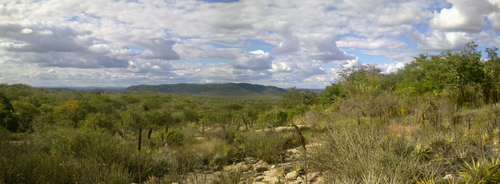
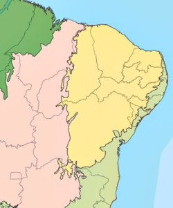
The Sertão is a term that evokes deep cultural and historical significance in Brazil. While it can broadly refer to any remote backland, in a modern context, it specifically describes the semi-arid region of northeastern Brazil. This vast territory spans parts of Alagoas, Bahia, Pernambuco, Paraíba, Rio Grande do Norte, Ceará, Maranhão, Piauí, Sergipe, and Minas Gerais. Its complex identity has been immortalized in literature, most notably in Euclides da Cunha's seminal work, Os Sertões (The Backlands).
Key Facts
- Climate: Semi-arid tropical, with irregular rainfall concentrated in a few months.
- Vegetation: Dominated by the Caatinga, a unique Brazilian biome.
- Geography: Primarily low uplands of the Brazilian Highlands, ranging from 200 to 500 meters above sea level.
- Economic History: Shaped by cattle ranching, cotton cultivation, gold mining, and diamond prospecting.
- Climate Challenges: Highly susceptible to droughts influenced by the El Niño phenomenon.
Geography and Climate
Geographically, the Sertão is characterized by low uplands that form part of the Brazilian Highlands. Most of the region sits between 200 and 500 meters above sea level. Higher elevations appear on the eastern edge at the Borborema Plateau, where the landscape transitions into the sub-humid Agreste. In the north, the region reaches the coastal plains of Rio Grande do Norte, while its southern boundary merges gradually into northern Minas Gerais.
The climate is predominantly semi-arid tropical. Temperatures typically average between 25°C and 30°C, though they can soar to 42°C in areas like south-central Piauí. Rainfall is notably irregular, usually occurring during a short "winter" period of three to five months in the first half of the year. Annual precipitation often falls between 400 mm and 700 mm, though some areas receive much less, while others exceed 1,000 mm.
The Impact of El Niño and Drought
Droughts in the Sertão are closely linked to El Niño, a phenomenon involving the warming of Pacific Ocean waters near the western coast of South America. This warming disrupts global wind circulation and rainfall patterns in northeastern Brazil. These droughts can be catastrophic, affecting an area equivalent to three times the size of the state of São Paulo, leading to significant losses in crops and livestock.
To mitigate these effects, the federal government established the Drought Polygon in 1951, a delimited area designed to facilitate targeted aid and combat drought. One practical solution for rural families is the use of cisterns; a 15,000-liter cistern can cost approximately R$ 1,800 and provide a family of five with water for seven to eight months of drought.
Historical Evolution of the Backlands
During the first century of Portuguese colonization, the focus remained on the coastal Zona da Mata for brazilwood and sugar production. The Sertão remained largely unexplored, sought out primarily by backwoodsmen searching for precious metals. Notable explorers like Belchior Dias Moreia ventured into the backlands of Bahia and Sergipe in the late 16th and early 17th centuries.
The expansion into the interior was largely driven by the cattle industry. As oxen became essential for sugarcane fields and food, herds multiplied, often clashing with plantations. This, combined with the Dutch invasions and the social rigidity of the sugar cycle, pushed various groups—including whites, mamelucos, mulattoes, and blacks—into the Caatinga to work as cowboys. By 1590, the conquest of Sergipe allowed cattle breeders to settle the right bank of the São Francisco River.
Mining and Agriculture
The Sertão's economy has seen several shifts. In the late 17th and early 18th centuries, gold was discovered in regions like Jacobina, attracting explorers and enslaved Africans. In the 1840s, diamond deposits in the Chapada Diamantina brought a new wave of miners and merchants. Additionally, the cultivation of mocó cotton, a native fiber with international demand, became a significant economic activity in the 18th and 19th centuries.
In the modern era, the São Francisco Valley has become a hub for irrigated agriculture, particularly fruit cultivation. More recently, the agricultural frontier has expanded into the MATOPIBA region, focusing on soybeans, maize, and cotton, though this expansion has also led to deforestation and the displacement of traditional communities.
Summary of Regional Characteristics
| Feature | Description |
|---|---|
| Primary Biome | Caatinga (Steppe savanna) |
| Climate Type | Semi-arid tropical |
| Key Economic Drivers | Cattle, Cotton, Fruit, Soybeans, Mining |
| Major Climate Risk | El Niño-induced drought |
| Water Solution | Cisterns (approx. 15,000 liters) |

Frequently Asked Questions
What is the Caatinga?
The Caatinga is the predominant vegetation of the Sertão, consisting of a steppe savanna that is unique to the Brazilian landscape.
How does El Niño affect the Sertão?
El Niño causes the warming of Pacific waters, which alters global wind patterns and reduces rainfall in the Sertão, leading to severe droughts.
What is the Drought Polygon?
The Drought Polygon is a geographic area delimited by the Brazilian government in 1951 to facilitate administrative actions and aid in combating the effects of drought.
What were the main historical economic activities in the region?
Historically, the region relied on cattle ranching, mocó cotton cultivation, gold mining, and diamond prospecting, moving into irrigated fruit and large-scale grain farming in modern times.
How do rural families manage water shortages?
Many families use cisterns with capacities around 15,000 liters to store water, which can sustain a family of five for several months during dry periods.