San Juan National Forest: A Colorado Wilderness Overview
Spanning over 1.8 million acres of rugged terrain, the San Juan National Forest stands as one of the most significant natural landscapes in western Colorado. This vast expanse of protected land encompasses much of the southern San Juan Mountains, offering a diverse ecosystem that ranges from high alpine peaks to lush river valleys. Managed by the U.S. Forest Service, the forest serves as a vital sanctuary for wildlife and a premier destination for outdoor enthusiasts.
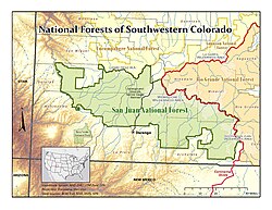
Geography and Location
The forest is situated in western Colorado, with its nearest major city being Durango. It covers a massive area of approximately 1,878,846 acres (7,603.42 km²), stretching across ten different counties: Archuleta, Conejos, Dolores, Hinsdale, La Plata, Mineral, Montezuma, Rio Grande, San Miguel, and San Juan.
Geographically, the forest is defined by its relationship to the Continental Divide of the Americas—the hydrological ridge that separates river systems flowing toward the Atlantic and Pacific Oceans. The San Juan National Forest occupies the land west of this divide, bordering the Uncompahgre National Forest to the north and the Rio Grande National Forest to the east.
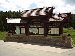
The San Juan Mountains
Much of the forest's character is derived from the San Juan Mountains. The forest's name is a tribute to the San Juan River, which was originally named Rio San Juan in honor of Saint John the Baptist (San Juan Bautista in Spanish).
Key Facts
- Total Area: 1,878,846 acres (7,603.42 km²)
- Established: June 3, 1905, by Theodore Roosevelt
- Governing Body: U.S. Forest Service
- Headquarters: Durango, Colorado
- Major Wilderness Areas: Weminuche, South San Juan, Lizard Head, and Hermosa Creek
- Notable Landmarks: Chimney Rock National Monument and the Durango and Silverton Narrow Gauge Railroad
History and Administration
The history of the San Juan National Forest dates back to the early 20th century. It was officially created by proclamation on June 3, 1905, under the administration of President Theodore Roosevelt. Today, the forest is managed through a centralized headquarters in Durango, supported by local ranger district offices located in Bayfield, Dolores, and Pagosa Springs.
In recent history, the forest's protected status was further expanded when President Barack Obama designated a portion of the forest as the Chimney Rock National Monument on September 21, 2012.
Protected Wilderness Areas
The San Juan National Forest contains several areas designated under the National Wilderness Preservation System. These areas are managed to preserve their natural conditions with minimal human interference. There are four primary wilderness areas associated with the forest:
- Hermosa Creek Wilderness: Located entirely within the San Juan National Forest.
- Lizard Head Wilderness: Partially extends into the Uncompahgre National Forest.
- South San Juan Wilderness: Mostly located within the Rio Grande National Forest.
- Weminuche Wilderness: Partially extends into the Rio Grande National Forest.
Additionally, the forest includes the Piedra Area and provides the scenic route for the historic Durango and Silverton Narrow Gauge Railroad, which traverses the forest landscape.
Summary of Forest Data
| Category | Details |
|---|---|
| Location | Western Colorado, USA |
| Total Acreage | 1,878,846 acres |
| Primary Mountains | San Juan Mountains |
| Nearest City | Durango, CO |
| Established Date | June 3, 1905 |
Frequently Asked Questions
Where is the headquarters for the San Juan National Forest?
The forest headquarters are located in Durango, Colorado.
Which counties are included in the San Juan National Forest?
The forest covers land in Archuleta, Conejos, Dolores, Hinsdale, La Plata, Mineral, Montezuma, Rio Grande, San Miguel, and San Juan Counties.
What is the significance of the Continental Divide to this forest?
The Continental Divide of the Americas serves as a geographic boundary, with the San Juan National Forest occupying the area to the west of the divide.
Are there any national monuments within the forest?
Yes, part of the forest was designated as the Chimney Rock National Monument by proclamation in 2012.
What wilderness areas can be found here?
The forest contains the Hermosa Creek, Lizard Head, South San Juan, and Weminuche wilderness areas.