Sahel: Geography, Climate, and the Challenges of a Vital African Belt
The Sahel is a vast, transitional belt of land in Africa that serves as a critical link between the Sahara Desert to the north and the more fertile tropical savannas to the south. Spanning approximately 5,400 km (3,360 mi) from the Atlantic Ocean to the Red Sea, this region is a complex mosaic of ecosystems, cultures, and environmental challenges. Stretching up to 1,000 km (620 mi) in width, the Sahel covers a massive area of roughly 3,053,200 km².
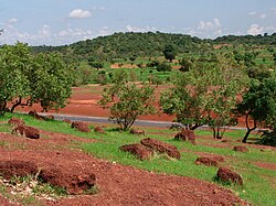
Key Facts
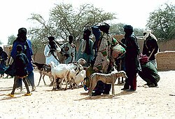
- Width and Length: A belt up to 1,000 km wide, spanning 5,400 km across Africa.
- Total Area: Approximately 3,053,200 km².
- Topography: Predominantly flat, with elevations mostly between 200 and 400 meters.
- Climate: Characterized by intense heat and highly irregular precipitation.
- Major Rivers: The Senegal, Niger, and Nile rivers flow through or near the region.
- Ecosystem: Tropical and subtropical grasslands, savannas, and shrublands.
Geography and Topography
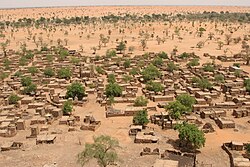
The landscape of the Sahel is largely defined by its flatness. Most of the region sits at a relatively low elevation, typically between 200 and 400 meters (660 and 1,310 ft). While the terrain is generally level, several distinct features rise from the plains, such as the Ennedi Plateau, the Aïr Mountains, and the Marrah Mountains. These elevated areas are often classified as separate ecoregions because they host unique flora and fauna that differ from the surrounding lowlands.
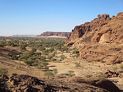
The Sahel acts as a massive corridor, touching numerous countries including Algeria, Burkina Faso, Cameroon, Cape Verde, Central African Republic, Chad, Eritrea, The Gambia, Mali, Mauritania, Niger, Nigeria, Senegal, South Sudan, and Sudan.
Climate and Precipitation Patterns
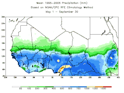
The Sahelian climate is defined by extreme seasonality and intense heat. The region experiences a very long dry season and a short, often unpredictable rainy season. Most precipitation occurs within a four-to-six-month window in the middle of the year. Because rainfall is so irregular, scientists often categorize the region into three distinct climatic subdivisions based on annual totals:
- Saharan-Sahelian: Mean annual precipitation between 100 and 200 mm.
- Strict Sahelian: Mean annual precipitation between 200 and 700 mm.
- Sahelian-Sudanese: Mean annual precipitation between 700 and 900 mm.
Temperature levels remain high year-round. During the hottest months, average high temperatures typically range from 36 to 42 °C (97 to 108 °F). Even during the "coldest" periods, average highs remain between 27 and 33 °C (81 to 91 °F). The region also enjoys high sunshine duration, with some areas receiving up to 3,600 hours of bright sunlight annually, a level comparable to desert environments.
Ecology: Flora and Fauna
As a biome of tropical and subtropical grasslands and shrublands, the Sahel supports a variety of specialized life forms. The vegetation is often dominated by acacia trees and various grasses that can withstand the intense heat and seasonal drought.
: The lush green of the Sahelian acacia savanna during the rainy summer season in Mali. Note the large baobab amongst the acacia.
The animal life includes:
- Mammals: Oryx, gazelles, and African buffalo.
- Livestock and Domesticated Animals: Camels and horses are common.
- Birds: A variety of migratory bird species utilize the region.
Historical and Modern Challenges
Drought and Famine
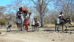
The Sahel has a long history of severe climatic fluctuations. Notable periods of hardship include a 250-year megadrought from 1450 to 1700 and a major famine in 1914. More recently, the period from 1951 to 2004 saw some of the most consistent and severe droughts in African history. A particularly devastating drought occurred in 2010, where extreme heat—reaching 48.2 °C (118.8 °F) in parts of Niger—combined with crop failure to cause widespread famine and disease.
Political and Social Instability
In recent years, the Sahel has faced significant security challenges. The region has become a focal point for terrorist violence, with reports indicating it contributed to 35% of all global deaths from terrorism by 2021. Additionally, the region has dealt with political instability and concerns regarding human rights violations by state security forces.
Summary of Sahelian Characteristics
| Feature | Description |
|---|---|
| Biome | Tropical and subtropical grasslands, savannas, and shrublands |
| Primary Rivers | Senegal, Niger, Nile |
| Climate Types | Tropical savanna (Aw), Hot Semi-arid (BSh), Hot Desert (BWh) |
| Elevation Range | 200 to 400 meters |
| Key Animals | Camels, horses, oryx, gazelles, African buffalo |
Frequently Asked Questions
What is the main difference between the Sahel and the Sahara?
The Sahara is a desert, whereas the Sahel is a semi-arid steppe or savanna that acts as a transition zone between the desert and more humid regions.
How does rainfall affect life in the Sahel?
Rainfall is highly irregular and concentrated in a few months of the year. This seasonality dictates the movement of people and livestock, as well as the growth cycles of local vegetation.
Which major rivers are found in the Sahel?
The Senegal, Niger, and Nile rivers are the primary river systems associated with the region.
What are the typical temperatures in the Sahel?
The Sahel is characterized by constant, intense heat. Average high temperatures during the hottest periods are between 36 and 42 °C (97 to 108 °F).
Why has the Sahel experienced so many droughts?
The region is naturally prone to irregular precipitation, and historical data shows long-term patterns of severe drought, including significant periods between 1951 and 2004.