Rhode Island and Southern Massachusetts Transportation Network
The transportation infrastructure connecting Rhode Island and southern Massachusetts is a complex web of rail, road, and air links designed to facilitate movement between major population centers and the Greater Boston area. From high-speed rail corridors to extensive local bus networks, the region provides diverse options for commuters and travelers alike.
Key Facts
- MBTA operates the commuter rail connecting Providence and other regional hubs to Boston.
- RIPTA manages local bus transit for 35 of Rhode Island's 39 communities.
- T.F. Green Airport serves as the primary regional airport, integrated with the MBTA rail line.
- Interstates 95 and 195 are the primary arterial roads connecting the region to New York City and Boston.
- Amtrak provides high-speed and regional rail via the Northeast Corridor.
Rail Infrastructure
Rail travel in the region is divided between commuter services and national intercity lines. The Massachusetts Bay Transportation Authority (MBTA) operates the Providence/Stoughton Line, which links the metropolitan area directly to Boston. This line includes stations in Providence, South Attleboro, Attleboro, and Mansfield. In 2012, the service was expanded to include Wickford Junction in North Kingstown and T.F. Green Airport in Warwick. Most recently, a Pawtucket/Central Falls station opened in January 2023.
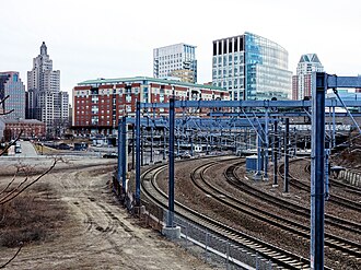
Expansion continues with the South Coast Rail project. The Fall River/New Bedford Line began operations in March 2025. A proposed second phase of this project aims to introduce a different routing to Boston and the addition of the Battleship Cove station.
Intercity Rail Services
Amtrak manages regional rail via the Northeast Corridor, a high-traffic rail line connecting the Northeastern United States. Northeast Regional trains serve both the Providence and Kingston stations, while the premium Acela service is available specifically in Providence.
Bus and Ferry Transit
Local transit is primarily managed by the Rhode Island Public Transit Authority (RIPTA), which operates its central hub in downtown Providence. RIPTA manages 55 bus lines, alongside paratransit and Flex services, covering 35 of Rhode Island's 39 communities as well as Seekonk and South Attleboro in Massachusetts.
Other regional providers include the Southeastern Regional Transit Authority (SRTA), serving Fall River and New Bedford, and the Greater Attleboro Taunton Regional Transit Authority (GATRA), which covers the Massachusetts portion of the metro area extending toward the South Shore.
Water Transportation
Ferry services provide essential links between the mainland and several islands, including Hog Island, Prudence Island, and Block Island. Additionally, a seasonal ferry operates between Newport and Providence from mid-October back to late May.
Air and Road Networks
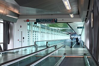
T.F. Green Airport in Warwick is the region's major aviation hub. Despite its location, it uses the airport code PVD. For international or larger-scale travel, many residents also utilize Logan International Airport in Boston. The integration of the MBTA Providence/Stoughton Line at T.F. Green provides seamless rail-to-air connectivity for those traveling to Boston or Providence.
Highway Systems
The region is anchored by two primary interstates. Interstate 95 runs diagonally across Rhode Island, linking the region to New York City and Boston, while Interstate 195 extends east from Providence toward New Bedford and Fall River. To reduce congestion, Interstate 295 serves as a bypass around the city of Providence.
Several key state routes supplement the interstate system:
- Route 146: Connects Providence and Worcester.
- Route 138: Serves the Newport area.
- Route 24: Links the Boston area with Newport and Fall River.
- Route 4: Serves the Wickford area.
- Route 99: Connects Woonsocket with Route 146.
- Route 140: Connects New Bedford with Route 24.
Transportation Summary
| Mode | Primary Provider/Route | Key Destinations |
|---|---|---|
| Commuter Rail | MBTA | Boston, Providence, T.F. Green Airport |
| Intercity Rail | Amtrak | Northeast Corridor (Providence, Kingston) |
| Local Bus | RIPTA, SRTA, GATRA | Rhode Island communities, Fall River, New Bedford |
| Air | T.F. Green (PVD) | Warwick / Regional |
| Highways | I-95, I-195, I-295 | Boston, New York City, South Coast |
Frequently Asked Questions
Which rail line connects Providence to Boston?
The MBTA Providence/Stoughton Line provides commuter rail service connecting the Providence metropolitan area to Boston.
How can travelers get to T.F. Green Airport via rail?
The MBTA Providence/Stoughton Line has a dedicated stop at T.F. Green Airport in Warwick, allowing passengers to travel directly to and from Providence and Boston.
What bus authority serves the majority of Rhode Island?
The Rhode Island Public Transit Authority (RIPTA) manages local transit, serving 35 of the state's 39 communities from its hub in downtown Providence.
Which interstates are most important for regional travel?
Interstate 95 is the primary route for travel toward Boston and New York City, while Interstate 195 connects Providence to Fall River and New Bedford.
Is there ferry service available in the region?
Yes, ferries connect the mainland to Block, Prudence, and Hog Islands. There is also a seasonal ferry between Providence and Newport running from late May to mid-October.