Puerto Iguazú: Argentina's Gateway to the Great Falls
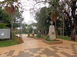
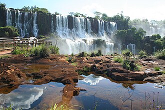
Located in the province of Misiones, Puerto Iguazú is a vibrant border city that serves as the primary hub for visitors traveling to one of the world's most spectacular natural wonders. With a population of 82,227 (as of the 2010 census), it stands as the fourth largest city in the province. Because the world-famous Iguazú Falls are situated just 18 kilometers (11 miles) away, the city has evolved into a tourism-centric destination with extensive infrastructure to support international travelers.
Key Facts
- Location: Misiones Province, Argentina, bordering Brazil and Paraguay.
- Primary Attraction: Proximity to the Iguazú Falls and Iguazú National Park.
- Climate: Humid Subtropical (Cfa) with abundant rainfall year-round.
- Economy: Heavily dependent on tourism and hospitality.
- Connectivity: Linked to Brazil via the Tancredo Neves Bridge.
A Journey Through History
The region's European history began in 1542 when Spanish explorer Álvar Núñez Cabeza de Vaca became the first European to discover the Iguazú Falls, drawn by the thunderous sound of the water audible from several kilometers away. At the time, the area was primarily inhabited by the Guaraní people.
For centuries, the Guaraní remained the sole occupants until 1880. In 1881, the Corrientes Province sold 13,000 square kilometers of land near the falls, which eventually became the property of Gregorio Lezama. Lezama funded scientific expeditions led by Carlos Bosetti and Jordan Hummel, who later organized the first tourist trips to the falls. By 1888, the land was sold to Martín Errecaborde and Company.
The settlement grew steadily through the late 19th and early 20th centuries. In 1902, the town was formally established as Puerto Aguirre, named in honor of Victoria Aguirre, who funded the town's first road and various civic improvements. The town was renamed Puerto Iguazú in 1943, coinciding with the growth of the Iguazú National Park, which had been established in 1934.
Climate and Natural Environment
Puerto Iguazú is characterized by a Humid Subtropical climate (classified as Cfa under the Köppen system). This means the region experiences warm winters and hot summers with no distinct dry season. Rainfall is abundant, with every month receiving at least 100 mm (3.9 in) of precipitation, peaking in November with over 200 mm (7.9 in) on average.
The hot season lasts six months or more, with daytime temperatures often ranging between 30 and 35 °C (86 to 95 °F). Conversely, the cool season (late April to mid-September) sees average highs of 21 °C (70 °F). While frost is rare, the record low temperature has plummeted to −4.9 °C (23.2 °F).
This consistent moisture supports the surrounding rainforests and the 12,620-hectare Iguazú National Reserve. This area preserves remnants of the Atlantic Forest, a subtropical ecosystem home to native bamboos and diverse bird species, including hummingbirds and toucans. Local wildlife, such as coatis, are frequently seen interacting with visitors.
Economy and Local Attractions
The local economy is centered almost entirely on tourism. The city hosts a wide array of international hotels, including the Sheraton Iguazú Resort & Spa, the Iguazú Grand Hotel and Casino, and the Amérian Portal del Iguazú.
Beyond the falls, visitors can explore several unique sites:
- Three Frontiers: The geographic point where the borders of Argentina, Brazil, and Paraguay meet.
- Cultural Sites: The Museum of Images of the Jungle (woodcarvings), the Mbororé Museum, and the La Aripuca resort.
- Nature Parks: The Luis Honorio Rolón Municipal Nature Park and the Güira Oga Center for Bird Rehabilitation.
- Wanda Mines: Located nearby, these mines have operated since the 1950s and are famous for agate, amethyst, quartz, and topaz.
Transport and Infrastructure
Puerto Iguazú is well-connected internationally and regionally. The Tancredo Neves International Bridge provides a direct link to Foz do Iguaçu, Brazil, connecting Argentine National Route 12 with Brazilian BR-469. Air travel is facilitated by the Cataratas del Iguazú International Airport, though many travelers also utilize the Foz do Iguaçu International Airport across the border.
Within the city, transport is managed via taxis and municipal buses, including a key route that connects the Three Frontiers area to the Iguazú National Park.
| Category | Details |
|---|---|
| Province | Misiones, Argentina |
| Population (2010) | 82,227 |
| Elevation | 162 m (531 ft) |
| Climate Type | Humid Subtropical (Cfa) |
| Key Infrastructure | Tancredo Neves Bridge, Cataratas del Iguazú International Airport |
Frequently Asked Questions
How far is Puerto Iguazú from the Iguazú Falls?
The city is located approximately 18 kilometers (11 miles) away from the falls.
What is the best time to visit based on weather?
The cool season runs from late April to mid-September, offering milder temperatures. However, the region receives abundant rainfall year-round, so visitors should be prepared for rain regardless of the month.
Which countries have consulates in Puerto Iguazú?
Both Brazil and Paraguay maintain consular representations within the city.
What can visitors find at the Wanda Mines?
The Wanda Mines are a popular destination for collectors of gemstones and geodes, specifically offering high-quality amethyst, agate, topaz, and quartz.
How do I get from Puerto Iguazú to Brazil?
Travelers can cross the border via the Tancredo Neves International Bridge, which connects Puerto Iguazú to Foz do Iguaçu.