Population Density by Country: Global Distribution and Data Analysis
Population density is a critical demographic metric that measures the number of people living per unit of area, typically expressed as inhabitants per square kilometre (km²) or square mile. By analyzing how populations are distributed across the globe, researchers and policymakers can better understand the pressures on land, resources, and infrastructure.
This analysis examines sovereign states, self-governing dependent territories, and de facto independent countries. To ensure consistency, the data follows the ISO 3166-1 standard, which is the international standard for country codes. This means that while most recognized nations are included, certain entities—such as the European Union or constituent countries not listed under ISO 3166-1—are excluded from the primary rankings.
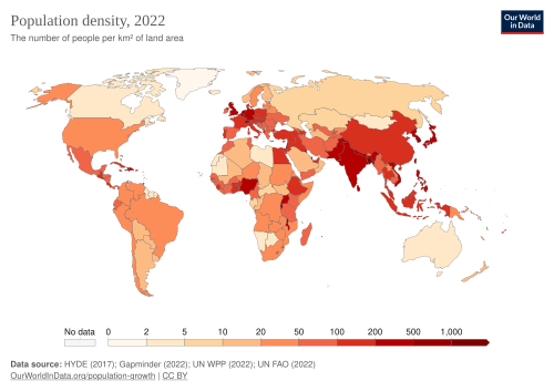
Key Facts
- Data Sources: Primary figures are derived from the United Nations World Population Prospects and the Food and Agriculture Organization (FAO).
- Measurement Scope: Area calculations include internal bodies of water, such as rivers, lakes, reservoirs, and bays.
- Temporal Scope: The data reflects figures from 2025; changes occurring between 2025 and 2026 are not recorded.
- Inclusion Criteria: The list covers sovereign states, dependencies (noted with parent states), and states with limited international recognition.
Methodology and Data Standards
Calculating population density requires precise data on both total population and total land area. For most locations, the United Nations provides the baseline using the latest official censuses. However, specific regional variations often require supplementary data from sources like the CIA World Factbook, the UK Office for National Statistics, or national census bureaus.
Handling Special Territories
Certain regions present unique challenges for demographic measurement. For example, the Palestinian Authority governs both the West Bank and the Gaza Strip, but these areas differ wildly in density. The Gaza Strip is significantly more crowded, with 5,950 people per km², compared to the West Bank's 575 people per km².
Similarly, small city-states like Vatican City require meticulous area measurements. While some historical sources cited 0.44 km², other records suggested 0.49 km². The official figure of 0.44 km² is used to calculate density based on the number of residents regardless of their citizenship status.
Data Variations and Exclusions
Not all data is uniform across all territories. Some figures exclude specific islands (such as Greenland or the Faroe Islands in certain datasets) or focus exclusively on metropolitan regions (such as metropolitan France). In cases where official census data is unavailable, estimates from academic sources or government agencies like the BBC or CIA are utilized to provide the most accurate approximation possible.
Summary of Demographic Data Sources
| Source Organization | Type of Data Provided | Scope |
|---|---|---|
| United Nations (World Population Prospects) | Population and Area | Global / Standardized |
| Food and Agriculture Organization (FAO) | Land and Area Figures | Global / Agricultural |
| CIA World Factbook | Area and Population Estimates | Regional / Specific Territories |
| National Statistics Offices (e.g., UK ONS) | Official Census Data | Country-Specific |
Frequently Asked Questions
What is population density?
Population density is the measurement of population per unit area, calculated by dividing the total population of a region by its total land area (including internal water bodies).
Which standard is used to define the countries in this list?
The list primarily uses the ISO 3166-1 standard, which defines codes for sovereign states and dependent territories, while also including de facto independent states with limited recognition.
How is the density of Vatican City calculated?
It is calculated using the official area of 0.44 km² and the total number of residents living there, regardless of whether they hold citizenship.
Why are some entities, like the European Union, excluded?
The European Union is a political and economic union rather than a single sovereign state or dependency listed under the ISO 3166-1 standard, and therefore does not fit the criteria for this specific ranking.
Does the area calculation include lakes and rivers?
Yes, the figures used for these calculations include internal bodies of water such as reservoirs, lakes, rivers, and bays.