Pisco, Peru: A Coastal Hub of History, Spirit, and Nature
Located in the Department of Ica, Pisco is a vibrant Peruvian city and the capital of the Pisco Province. Sitting just 9 meters above sea level, this coastal settlement is far more than just a geographic coordinate; it is the namesake of Peru's world-famous grape brandy and a gateway to some of the most breathtaking natural wonders in South America.
Founded in 1640 near an indigenous settlement, Pisco's early prosperity was driven by its fertile vineyards. The city became a critical trade hub, exporting its signature liqueur to the Pacific and Europe, establishing a legacy of commerce and craftsmanship that persists today.
Key Facts
- Location: Ica Region, Peru (13°43′S 76°12′W).
- Population: Approximately 104,656 (2015 estimate).
- Climate: Hot arid desert climate (BWh).
- Key Industry: Historically renowned for grape brandy (Pisco).
- Major Landmark: Gateway to the Paracas National Reserve.
A Turbulent and Triumphant History
Early Foundations and the Spirit of Pisco
The origins of the city are tied to the town of Santa Maria Magdalena, founded in 1572. The nearby port, named Pisco after the local valley, became a vital distribution point for the region's liqueur. As international sailors visited the port, demand for the grape brandy grew, and eventually, both the town and the drink adopted the name "Pisco." By the 17th century, the product was distributed across the coasts of Peru and Chile.
Pirates and Natural Disasters
Pisco's history has been marked by resilience. In 1685, the city was pillaged by English pirates, including Clerck and David. Shortly after, in 1687, a devastating earthquake and subsequent tsunami destroyed much of the city. In 1689, Viceroy Melchor Antonio Portocarrero Lazo de la Vega reestablished the city in its current location as the "Villa de Nuestra Señora de la Concordia de Pisco."
The Path to Independence
Pisco played a pivotal role in the liberation of Peru. In 1820, the Liberating Expedition led by José de San Martín and Bernardo O'Higgins Riquelme disembarked in the Bay of Paracas. It was here that the first national emblem and flag of Peru were created. In recognition of its importance, the city was later granted the title "Villa y Puerto de la Independencia" and was elevated to the rank of city in 1898.
The 2007 Earthquake
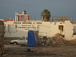
Modern Pisco faced a severe trial on August 15, 2007, when an 8.0-magnitude earthquake struck. The city was near the epicenter, resulting in the destruction of 80% of its infrastructure, including the San Clemente Cathedral. This event accounted for roughly 30% of the total fatalities of the earthquake, and the city has spent years recovering from the tragedy.
Geography and Climate
Pisco is characterized by a desert climate (classified as BWh under the Köppen system), meaning it is hot and arid with extremely low rainfall year-round. The average annual rainfall is a mere 1.5 mm.
| Metric | Average Value | Range/Notes |
|---|---|---|
| Maximum Temperature | 23.7 °C (74.7 °F) | Peak: 27.7 °C (Feb) / Low: 20.2 °C (Jul) |
| Minimum Temperature | 15.8 °C (60.4 °F) | Peak: 19.5 °C (Feb) / Low: 12.9 °C (Aug) |
| Annual Rainfall | 1.5 mm (0.1 in) | Extremely low throughout the year |
| Relative Humidity | ~81% - 84% | Consistently high coastal humidity |
Tourism and Cultural Attractions
The word "Pisco" comes from the Quechua word for "bird," a fitting name given the region's incredible biodiversity. Visitors are drawn to the Paracas National Reserve, often called the "Peruvian Galápagos." Boat tours to the Islas Ballestas allow visitors to see sea lions, turtles, dolphins, whales, and various bird species such as penguins, Peruvian boobies, and Inca terns.
For those interested in ancient mysteries, El Candelabro is a massive geoglyph etched into the sand, created using methods similar to those of the Nazca Lines. History enthusiasts can also explore Tambo Colorado, a well-preserved Inca site located just off the road to Ayacucho.
Within the city, the Plaza de Armas is a hub of activity where locals sell tejas (pecan and dried fruit sweets). Architectural highlights include the Municipal Palace, the former residence of José de San Martín, and the baroque Iglesia de la Compañía, which dates back to 1689 and features a gold-leaf altarpiece.
Infrastructure and Transport
Pisco is served by the Capitán FAP Renán Elías Olivera Airport (PIO). This international facility is shared with the Peruvian Air Force and serves as a critical backup for Lima's Jorge Chávez International Airport. Renovations initiated in 2012 aimed to increase the airport's capacity to handle 400,000 passengers annually.
Frequently Asked Questions
What is the origin of the name Pisco?
Pisco is a Quechua word meaning "bird," referring to the abundance of avian wildlife in the region.
What is the significance of Pisco in Peruvian independence?
The Bay of Paracas in Pisco was the landing site for José de San Martín's Liberating Expedition in 1820, where Peru's first flag and national emblem were created.
What can visitors see at the Islas Ballestas?
Visitors can observe a wide array of marine life, including sea lions, penguins, dolphins, whales, and various bird species like cormorants and Peruvian boobies.
How did the 2007 earthquake affect the city?
An 8.0-magnitude earthquake destroyed approximately 80% of the city, including the San Clemente Cathedral, and caused a significant portion of the total fatalities associated with the disaster.
What are tejas?
Tejas are traditional small sweets made from pecans and assorted dried fruits, commonly sold in the Plaza de Armas.