Paris Metropolitan Area: Statistics, Growth, and Functional Reach
The Paris metropolitan area (French: Aire urbaine de Paris) is a specialized statistical designation used to measure the reach of commuter movement between the city of Paris, France, and its surrounding suburbs. Unlike a political boundary, this area defines the functional influence of the city based on where people live and work.
Because it is based on commuting patterns, the boundaries of the metropolitan area are fluid, expanding as the city's economic influence reaches further into the French countryside.
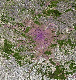
Key Facts
- Total Population: 15,064,617 (Metro).
- Total Area: 18,941 km² (7,313 sq mi).
- Nominal GDP: €865.65 billion (2024).
- Composition: Includes 1,929 communes as of 2022.
- Population Density: 690 people per km².
- Largest City: Paris, with a population of 2,165,423.
Defining the Metropolitan Area
The concept of the metropolitan area in France is managed by INSEE (the national statistical bureau). Historically, INSEE used the term aire urbaine (urban area) to describe suburban development around growth centers. In 2011, the largest of these were reclassified as aires métropolitaines (metropolitan areas), making Paris the largest in the country.
In 2020, INSEE updated its terminology, introducing the functional area (aire d'attraction d'une ville). This new model consists of an urban cluster and its surrounding commuting zone, aligning French data with Eurostat's functional urban area standards.
Statistical vs. Administrative Boundaries
It is important to distinguish the statistical metropolitan area from administrative structures. While the statistical area is used for demographic studies, economic statistics in France still rely on traditional subdivisions: the commune (municipality), département, and région.
A separate entity, the Métropole du Grand Paris (Greater Paris metropolitan authority), was established on January 1, 2016. This is an intercommunal cooperation effort that covers a much smaller territory than the INSEE statistical area, focusing primarily on Paris and its immediate neighboring departments (the petite couronne).
Geographic Extent and Expansion
As of 2022, the Paris metropolitan area covers 18,941 km², extending well beyond the administrative borders of the Île-de-France region (which measures 12,012 km²). This expansion means the metropolitan area now encompasses parts of several other departments, including Aisne, Aube, Eure, Eure-et-Loir, Loiret, Marne, Oise, Seine-Maritime, and Yonne.
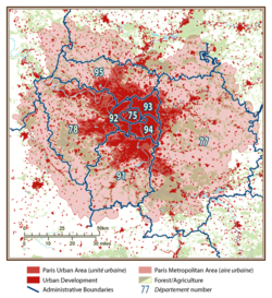
The area grows with each population census. When a surrounding commune meets the required commuter threshold—meaning a significant percentage of its residents work in the urban center—it is absorbed into the statistical metropolitan area.
Population Growth Trends
The Paris metropolitan area is a massive demographic hub, housing nearly 20% of the total population of France. Its growth over the last century demonstrates the rapid urbanization of the region.
| Year | Population | Communes | Area (km²) |
|---|---|---|---|
| 1901 | 3,460,000 | - | - |
| 1968 | 8,368,459 | 279 | - |
| 1999 | 11,174,743 | 1,584 | 14,518 |
| 2010 | 12,223,100 | 1,751 | 17,194 |
| 2018 | 13,064,617 | 1,929 | 18,941 |
Frequently Asked Questions
What is the difference between the Paris metropolitan area and the Métropole du Grand Paris?
The Paris metropolitan area is a statistical tool used by INSEE to measure commuter movement and demographic reach. The Métropole du Grand Paris is an actual administrative authority created for intercommunal cooperation, covering a significantly smaller geographic area.
How is a commune added to the metropolitan area?
A commune is included in the statistical area when it meets a specific commuter threshold, meaning a sufficient number of its inhabitants travel to the urban center for work.
Does the metropolitan area stay within the Île-de-France region?
No. The statistical metropolitan area is larger than the Île-de-France region and extends into several other departments, such as Oise, Marne, and Loiret.
Who manages the statistics for the Paris metropolitan area?
The statistics are managed by INSEE, France's national statistical bureau, which ensures the data matches international demographic standards.