Paraguay River: The Vital Waterway of South America
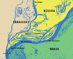
The Paraguay River (known as Ysyry Paraguái in Guarani) is one of South America's most critical arterial waterways. Stretching approximately 2,621 kilometers (1,629 miles), it serves as a lifeline for several nations, flowing through Brazil and Paraguay while defining international borders between Paraguay and Argentina, Brazil and Bolivia, and Brazil and Paraguay.
From its headwaters in the Brazilian highlands to its eventual confluence with the Paraná River, this waterway is more than just a geographic feature; it is a primary engine for trade, a sanctuary for biodiversity, and a defining element of the regional landscape.
Key Facts
- Total Length: 2,621 km (1,629 mi).
- Basin Size: Approximately 1,095,000 to 1,120,154 km².
- Primary Role: Second major river of the Rio de la Plata Basin.
- Navigability: One of the longest navigable rivers in South America, second only to the Amazon.
- Ecological Significance: Primary waterway for the Pantanal, the world's largest tropical wetland.
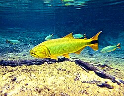
- Key Species: Home to about 350 fish species, including the golden dorado.
Course and Geography
The river begins its journey at the Parecis Plateau in the Brazilian state of Mato Grosso, south of Diamantino. It initially flows southwesterly through the city of Cáceres before turning south to traverse the Pantanal—a massive tropical wetland. After passing Corumbá, the river skirts the Brazil-Bolivia border.
As it enters Paraguay, the river becomes a central dividing line. It separates the semi-arid, sparsely populated Gran Chaco region to the west from the lush, forested eastern departments, where roughly 98% of Paraguay's population resides. After passing the capital city of Asunción and meeting the Pilcomayo River, the waterway forms the border with Argentina for 275 kilometers before merging into the Paraná River.
Economic Importance and Human Use
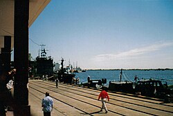
Because the Paraguay River has not been dammed for hydroelectric power, it remains highly navigable. This characteristic makes it an indispensable shipping corridor for landlocked Bolivia and Paraguay, providing their only reliable commercial link to the Atlantic Ocean via the Rio de la Plata.
Beyond industrial shipping, the river supports local economies through fishing and agricultural irrigation. For many riverside communities, the river is the primary source of sustenance and income. However, this dependence comes with risks; seasonal flooding frequently displaces thousands of residents in urban centers like Asunción, necessitating emergency housing interventions by the military.
Environmental Characteristics and Biodiversity
The river's water quality varies significantly along its course. In the upper reaches, such as the Rio da Prata near Bonito, the waters are exceptionally clear. However, after the confluence with the Bermejo River, the sediment load increases from 100 mg/L to approximately 600 mg/L, and the pH levels can rise to 8.2.
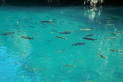
The river's temperature and clarity fluctuate with the seasons. During the low-water season, the water is warmer (often above 27°C) and more turbid. During the flood season, the water is cooler (18–26.3°C) and clearer. This dynamic environment supports a rich array of fauna, including over 80 endemic fish species. The river is dominated by characiforms (tetras) and siluriforms (catfish), with the golden dorado serving as both a prized game fish and a food source.
The Pantanal and the Hidrovia Controversy
The Paraguay River is the lifeblood of the Pantanal, a 147,629-square-kilometer wetland. The ecological health of this region depends entirely on the river's natural flow. This has led to a long-standing conflict regarding the Hidrovia project.
Proposed by the Hidrovia Inter-Governmental Commission, the plan aimed to transform the river into an industrial waterway to lower the cost of exporting soybeans. The project suggested dredging, rock removal, and the construction of dams. Environmental coalitions, such as Rios Vivos, successfully delayed the project by highlighting the potentially devastating impact on the Pantanal's ecology. The final fate of the project remains uncertain, balancing economic gain against environmental preservation.
Summary of River Specifications
| Feature | Detail |
|---|---|
| Source | Parecis Plateau, Brazil (434 m elevation) |
| Mouth | Paraná River (50 m elevation) |
| Average Discharge | 4,550 to 5,493 m³/s |
| Typical pH (Upper) | 5.8 – 7.4 |
| Typical pH (Lower) | 6.3 – 7.9 |
| Major Tributaries | Cuiabá, Apa, Pilcomayo, Bermejo |
Frequently Asked Questions
Why is the Paraguay River so important for Bolivia and Paraguay?
Since both nations are landlocked, the river serves as a critical navigable corridor that allows them to transport goods and trade with the rest of the world via the Atlantic Ocean.
What is the Pantanal and how does the river affect it?
The Pantanal is the world's largest tropical wetland. The Paraguay River provides the essential water supply that sustains this ecosystem; any significant alteration to the river's flow could devastate the wetland's biodiversity.
What is the "Hidrovia" controversy?
It is a dispute over a proposed industrialization project to dredge and restructure the river for cheaper soybean exports, which environmentalists argue would destroy the delicate ecology of the Pantanal.
Which fish species are most common in the Paraguay River?
About 80% of the fish species are characiforms (such as the golden dorado and black phantom tetra) and siluriforms (catfish).
Who were the original inhabitants of the upper river region?
The upper Paraguay River was originally inhabited by the Guarani peoples before European exploration began in the 16th century.