Ordnance Survey National Grid: The Standard for British Mapping
The Ordnance Survey National Grid (OSGB), also known as the British National Grid (BNG), is the primary geographic reference system used to pinpoint locations across Great Britain. Unlike latitude and longitude, which use angular measurements, the OSGB describes any location based on its distance from a specific origin point located to the west of the Isles of Scilly.
Developed by the Ordnance Survey (OS), this system is the foundation for official survey data and is widely adopted by commercial map producers, government planning departments, and outdoor guidebooks. While other systems exist for the British Isles—such as the Irish grid reference system and the Irish Transverse Mercator (ITM) for Ireland, or the Universal Transverse Mercator (UTM) for the Channel Islands—the OSGB remains the definitive standard for Great Britain and the Isle of Man.
Key Facts
- Origin: A false origin located south-west of the Isles of Scilly to avoid negative numbers.
- Datum: Based on the OSGB36 datum and the Airy 1830 ellipsoid.
- Projection: Uses a Transverse Mercator projection.
- Precision: Can range from 1 km squares (four digits) to 1 m squares (ten digits).
- Standard Reference: The six-figure grid reference is the most common, identifying a 100 m square.
How Grid Letters Work
The system organizes Great Britain into a hierarchy of squares. The first level consists of 25 large squares, each measuring 500 km by 500 km, labeled A to Z (omitting the letter 'I'). For Great Britain, the most significant land areas fall within squares S, T, N, and H. A tiny portion of North Yorkshire, specifically Beast Cliff, falls into the O square.
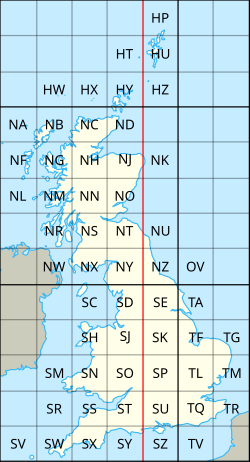
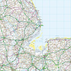
Each 500 km square is further subdivided into 25 smaller squares of 100 km by 100 km. These are also assigned letters from A to Z (omitting 'I'), starting from the north-west corner (A) and moving to the south-east (Z).
Understanding Grid Digits
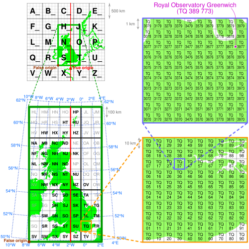
Within these 100 km squares, locations are identified using eastings (distance east from the square's west boundary) and northings (distance north from the square's south boundary).
The resolution of a reference depends on the number of digits used. For example, a four-figure reference (two digits for easting, two for northing) identifies a 1 km square. A six-figure reference, such as NN 166 712 for the summit of Ben Nevis, identifies a 100 m square. For maximum precision, ten-digit references can pinpoint a location down to 1 meter.
All-Numeric and Abbreviated References
Grid references can be expressed as a pair of large numbers representing total meters from the south-west corner of the SV square. Alternatively, an abbreviated alphanumeric reference may omit the letters entirely (e.g., 166712 instead of NN166712). This shorthand is typically used when the map sheet or general area is already known.
The Science of the System: Datums and Projections
The grid is based on the OSGB36 datum, introduced following a retriangulation effort between 1936 and 1962. This datum utilizes the Airy ellipsoid, a mathematical model of the Earth's shape specifically optimized for the British region. The Airy ellipsoid is approximately 1 km smaller in diameter and slightly less flattened than the global ellipsoids used by GPS.
To project the curved surface of the Earth onto a flat map, the OSGB uses a Transverse Mercator projection. The "true origin" is located at 49° N, 2° W in the English Channel. To minimize scale error, a scale factor of 2499/2500 is applied, ensuring the map scale is most accurate along two secant lines roughly 180 km east and west of the central meridian.
Datum Shifts and Transformations
Because the OSGB36 datum differs from modern geocentric frames like WGS 84 (used by GPS), a "datum shift" occurs. For instance, in Cornwall, WGS 84 longitude meridians are about 70 meters east of OSGB36 equivalents. To convert between these systems with high accuracy, the Ordnance Survey provides the OSTN15 transformation, which achieves sub-metre accuracy by modeling distortions from the original retriangulation.
Coordinate System Summary
| Parameter | Value |
|---|---|
| Datum | OSGB36 |
| Map Projection | Transverse Mercator (Redfearn series) |
| True Origin | 49° N, 2° W |
| False Origin | 400 km west, 100 km north of True Origin |
| Scale Factor | 0.9996012717 |
| EPSG Code | EPSG:27700 |
| Ellipsoid | Airy 1830 |
| Semi-major axis (a) | 6,377,563.396 m |
| Semi-minor axis (b) | 6,356,256.909 m |
Frequently Asked Questions
What is the difference between a grid reference and latitude/longitude?
Latitude and longitude use angular coordinates to locate a point on a sphere. A grid reference uses a flat, Cartesian coordinate system (eastings and northings) to measure distance from a fixed origin point.
Why is the letter 'I' omitted from the grid squares?
The letter 'I' was previously used in a military grid system and is omitted from the current OSGB system to avoid confusion.
What is a six-figure grid reference?
A six-figure grid reference uses three digits for the easting and three for the northing. This allows a user to pinpoint a specific 100-meter square within a larger 100 km grid square.
How does OSGB36 differ from WGS 84?
OSGB36 is a local datum based on the Airy ellipsoid, optimized for Great Britain. WGS 84 is a global geocentric datum used by GPS. Because they use different models of the Earth's shape, the same physical location will have different coordinates in each system.
What is the OSTN15 transformation?
OSTN15 is the definitive transformation provided by the Ordnance Survey to convert coordinates between the ETRS89 (a modern European standard) and the OSGB36 grid with sub-metre accuracy.